
 United Kingdom
 France
 Germany
 Netherlands
 Sweden
 USA
USA
 Italy
Italy
 Spain
Spain
More From Contributor


Cappadocia
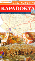
Cappadocia (Kapadokya) at 1:250, 000 from Mepmedya is a tourist map covering the famous region, showing transport routes and annotated with many natural and historic sites. Legend and text in English, Turkish and German.Major, secondary and many minor roads are shown, as are railway lines and the local airport at Kayseri. Mountain passes are displayed alongside an indication of their altitude. Provinces and districts are delineated, and provincial capitals, major towns, and many smaller towns and villages are marked, with an indication of their administrative importance.Relief shading defines the terrain, mountain ranges are named and spot heights are shown for major peaks. The main lakes, rivers and dams are marked and named, and caves and springs are also displayed.The mapping
is annotated with numerous places of interest. These range from churches, monasteries, mosques, castles and historic sites, to museums and the ski centre at Erciyes. The most important sites are numbered, with descriptions appearing on the reverse of the map. These include: a concentration of sites in the Goreme National Park area, the underground cities of Kaymakli and Derinkuyu, many museums, churches, mosques and monasteries, and areas of natural beauty where `fairy chimney` rock formations can be found.The map covers an area from the town of Aksaray in the west to Kayseri in the east, and from Kirsehir in the north to the town of Nigde in the south. This roughly corresponds to Nevsehir Province and some parts of neighbouring provinces.*Legend and descriptions in Turkish,
English and German.*

Product Description
Reviews/Comments
Add New
Vouchers
No voucher codes found.
Do you know a voucher code for this product or supplier? Add it to Insights for others to use.
Do you know a voucher code for this product or supplier? Add it to Insights for others to use.
 Denmark