
 United Kingdom
 France
 Germany
 Netherlands
 Sweden
 USA
USA
 Italy
Italy
 Spain
Spain
More From Contributor


Canada West
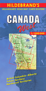
Western Canada at 1:1, 500, 000 on a large, double-sided map from Hildebrand providing coverage of Alberta and British Columbia including the Canadian Rockies, with most of Yukon and Northwest Territories. Locations of interest are prominently highlighted and numerous topographical features are named.The map presents the region’s road network indicating winter roads and providing driving distances on many local routes. Railway lines are included and local airports are marked. Locations of particular interest are prominently highlighted and the map shows numerous campsites. Topography of this mountainous region is indicated by relief shading with plenty for names of topographic features: mountain ranges, peaks (heights in metres), rivers and lakes. Latitude and longitude lines are
drawn at intervals of 1° and the time zone boundary is marked. Map legend includes English.
drawn at intervals of 1° and the time zone boundary is marked. Map legend includes English.

Product Description
Reviews/Comments
Add New
Intelligent Comparison
Archived Product
Canada West Stanfords
£5.99
Archived Product
Canada East Stanfords
£8.99
Archived Product
China West Stanfords
£9.50
Archived Product
Canada Wrap Stanfords
£3.25
Archived Product
Canada Stanfords
£13.59
Archived Product
Canada Stanfords
£12.79
Archived Product
Canada Stanfords
£6.99
Archived Product

Canada Stanfords
£9.99
Vouchers
No voucher codes found.
Do you know a voucher code for this product or supplier? Add it to Insights for others to use.
Do you know a voucher code for this product or supplier? Add it to Insights for others to use.
 Denmark