
 United Kingdom
 France
 Germany
 Netherlands
 Sweden
 USA
USA
 Italy
Italy
 Spain
Spain
More From Contributor


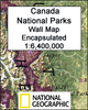
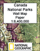
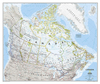


Canada National Parks
Canada’s 42 National Parks highlighted by the National Geographic on a folded map of the whole country with enlargements for the most popular locations such as Banff or Jasper plus lists of National Historic Sites of Canada, etc. The map presents the country against a light beige background, with its topography indicated by relief shading and the division into provinces. All the parks are prominently highlighted and the map also shows locations of Marine Conservation Areas and selected National Historic Sites administered by the Parks Canada institution. Separate lists name other Historic Sites in Ontario, Quebec, the Atlantic Provinces, and the Banff and Jasper National Parks.Additional six panels of enlargements, accompanied by notes, present in greater detail Banff, Jasper,
Yoho, Riding Mountain, Gross Morne and Cape Breton Highlands National Parks. The text and where appropriate park and other place names are given in both their English and French versions.This title is also available as a wall map, either on paper or encapsulated for greater durability.
Yoho, Riding Mountain, Gross Morne and Cape Breton Highlands National Parks. The text and where appropriate park and other place names are given in both their English and French versions.This title is also available as a wall map, either on paper or encapsulated for greater durability.

Product Description
Reviews/Comments
Add New
Vouchers
No voucher codes found.
Do you know a voucher code for this product or supplier? Add it to Insights for others to use.
Do you know a voucher code for this product or supplier? Add it to Insights for others to use.
 Denmark