
 United Kingdom
 France
 Germany
 Netherlands
 Sweden
 USA
USA
 Italy
Italy
 Spain
Spain
More From Contributor


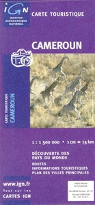
Cameroon
General road map with a large number of small villages and settlements. Relief shading indicates the terrain, showing forested areas, the savanna, swamps, and places liable to flooding. Road network shows which secondary roads are passable only during the dry season and highlights scenic routes. Other information includes railways, petrol stations, accommodation, hospitals, post offices, as well as places of interest.The map also includes small insets showing the surroundings of Yaoundé and Douala. Latitude and longitude are shown in the margins at intervals of 2 degrees and idicated by ticks on the map itself. The legend is in French and English.

Product Description
Reviews/Comments
Add New
Intelligent Comparison
Archived Product
Cameroon Stanfords
£10.95
Archived Product

Camera Stanfords
£7.99
Archived Product
Caesarion Stanfords
£12.99
Vouchers
No voucher codes found.
Do you know a voucher code for this product or supplier? Add it to Insights for others to use.
Do you know a voucher code for this product or supplier? Add it to Insights for others to use.
 Denmark