More From Contributor

£10.00
Camden Town perfectly embodies the cultural mix for which London is famed. Alongside the buzzing Lock market, the pubs & music venues & the eclectic shops, there is another Camden
- impossible crowds, shameful poverty, bad housing, gang fights, murders... This book takes five landmarks as the starting point for a series of journeys into the layers of history & culture that make Camden Town. The World`s End pub existed in various forms before Camden began. The Regent`s Canal Bridge is where today`s crowds flock to the locks & market, while Arlington House, just a block away, belongs to a parallel Camden of immigration & new beginnings, poverty & homelessness. No. 8 Royal College Street represents how, even with the first buildings of nineteenth-century Camden Town, social outsiders were attracted to the area. Meanwhile the Roundhouse, an engineering curiosity, was to become the revered centre of Camden`s cultural scene.
...
Archived Product
£3.50
Camelford in 1905 in a fascinating series of reproductions of old Ordnance Survey plans in the Alan Godfrey Editions, ideal for anyone interested in the history of their neighbourhood or family. The map covers the small market town of Camelford, founded by Earl Richard of Cornwall, brother of Henry III, in the mid-13th century. The town itself is covered, along with the outlying hamlets of Treclago, Pencarrow, Valley Truckle, Fenteron, Trevia, Jetwells, Trewen, Hendra. Features include the Workhouse, River Camel, High Street, Town Hall, Fore Street, Outground Mill, Grammar School. (Note that the station is not on the map.) On the reverse are 1910 directories for Camelford & Llanteglos-by-Camelford. About the Alan Godfrey Editions of the 25” OS Series Selected towns in Great Britain & Ireland are covered by maps showing the extent of urban development in the last decades of the 19th & early 20th century. The plans have been taken from the Ordnance Survey mapping & reprinted at about 15 inches to one mile (1:4, 340). On the reverse most maps have historical notes & many also include extracts from contemporary directories. Most maps cover about one mile (1.6kms) north/south, one & a half miles (2.4kms) across; adjoining sheets can be combined to provide wider coverage.FOR MORE INFORMATION & A COMPLETE LIST OF ALL AVAILABLE TITLES PLEASE CLICK ON THE SERIES LINK. ...
Archived Product
£7.99
Simply, put, Jean-Philippe Toussaint is one of the most original novelists working today, & will almost undoubtedly go down as one of the great comic writers of our era. Toussaint has been likened to some diverse artists (Jim Jarmusch, Samuel Beckett, Nicholson Baker), but perhaps the most apt comparison is to Charlie Chaplin, for a few reasons. 1) Like Chaplin, he turns regular-life situations into comedy by the slightest & subtlest exaggerations; 2) He loves ”stills, ” moments when our attention freezes on some detail of everyday life & it strikes us as ridiculous; 3) His stories move from scene to scene with often only the flimsiest excuse for an over-reaching plot, although what we come away with is not just a patchwork of set pieces but rather a surprising feeling of melancholy. Toussaint`s contemporary existentialism is as poignant as it is funny. As the narrator of Toussaint`s novel Monsieur says in his closing line: ” Life, mere child`s play, for Monsieur.” ...
Archived Product
£10.95
General road map with a large number of small villages & settlements. Relief shading indicates the terrain, showing forested areas, the savanna, swamps, & places liable to flooding. Road network shows which secondary roads are passable only during the dry season & highlights scenic routes. Other information

Includes::
railways, petrol stations, accommodation, hospitals, post offices, as well as places of interest. The map also

Includes::
small insets showing the surroundings of Yaound


...
Archived Product
£10.99
General road map with a large number of small villages & settlements. Relief shading indicates the terrain, showing forested areas, the savanna, swamps, & places liable to flooding. Road network shows which secondary roads are passable only during the dry season & highlights scenic routes. Other information

Includes::
railways, petrol stations, accommodation, hospitals, post offices, as well as places of interest. The map also

Includes::
small insets showing the surroundings of Yaoundé & Douala. Latitude & longitude are shown in the margins at intervals of 2 degrees & idicated by ticks on the map itself. The legend is in French & English.


...
Archived Product
£10.50
Cameroon & Gabon at 1:1, 300, 000 on a light, waterproof & tear-resistant, indexed road map with topographic & tourist information, published by Reise Know-How as part of their highly acclaimed World Mapping Project. The map is double-sided to provide the best balance between a good scale & a convenient size sheet. The whole of each country is on one side of the map, with coverage also including Equatorial Guinea with Isla de Bioco, & São Tomé e Príncipe. Topography is shown by altitude colouring with contours, spot heights, & graphics for marshlands & seasonal rivers & lakes. National parks & protected areas are highlighted. Road network

Includes::
local dirt tracks, indicating driving distances on main roads & locations of petrol stations. Railway lines & local airfields are also marked. Internal administrative boundaries are shown with names of the provinces. A wide range of symbols highlights various places of interest, including archaeological remains, selected hotels & campsites, beaches, etc. The map has a latitude & longitude grid at intervals of 1°. A separate index of place names is provided for each side, with a list of national parks & reserves. Map legend

Includes::
English.*” World Mapping Project”* is an extensive series of maps at varying scales, aiming to provide coverage of countries & regions worldwide using clear, well presented cartography with both topographic & tourist information.


...
Archived Product
£15.99
Cameroon in the Travel Guide series from Bradt; encompassing a comprehensive range of titles to destinations worldwide, with a particular focus on Africa, Central & South America. Bradt are one of the country’s leading independent publishers & have an ethos that focuses on responsible travel, in alliance with a philosophy of sustainability; both in the destinations the guides cover but also in encouraging tourists to limit the impact they have on the local environment. Bradt guides have a reputation for appealing to more independent travelers & often cover destinations that are not available from other publishers. Each guide opens with two comprehensive chapters on Background & Practical Information, covering details of the country’s geography, culture, natural history, government & politics, economy, people, language, religion, education & culture. Important practical advice

Includes::
when to visit, highlights, suggested itineraries, tour operators, red tape, embassies & consulates, getting there & away, health, safety, what to take, money, budgeting, getting around, accommodation, eating & drinking, public holidays, shopping, arts & entertainment, media & communications, business, travel culture & cultural etiquette. Individual sections are organized geographically by region & typically open with information on practicalities & orientation, before focusing on what to see & where to go. Information on what to see, where to stay, where to eat & how to find your way around is provided, with a range of budgets catered for. Simple black & white maps locate key visitor sites & places of accommodation. Bradt Travel Guides include appendices that provide an in-depth introduction to the language of each country, a glossary of terms & a listing of books & internet resources providing further information on the destination.

...
Archived Product
£15.99
The new edition of Cameroon features every aspect of travel in the little-known west African country. Cameroon offers 'pygmy' hunting camps deep in the rainforest, Arabic-speaking trading towns, ancient tribal kingdoms, mountain scenery, & fabulous beaches. Its varied population bears Muslim, Christian, British & French influences & although officially bilingual, around 160 different African dialects are spoken. Wildlife watching is a prime reason for visiting this corner of West Africa: this book incorporates a useful field guide to the main species of animals in Cameroon, recommendations on birding from experts & the best habitats to be found in the reserves, national parks & conservation areas. ...
Archived Product
£7.99
The very stuff of travel writing. Trekking through the bush on a horse called Egbert, eating repulsive local delicacies, getting lost, falling ill, heat, storms & unplanned detours. Murphy & her teenage daughter`s journey is written up with sympathy, wit & perception. ...
Archived Product
£11.50
The Bear Trail, Camí de l`Óssa, a circular hiking route in Andorra on a contoured & GPS compatible map at 1:15, 000 from Editorial Piolet, with eight additional recommended walks from Encamp. The map has contours at 10m intervals enhanced by bold relief shading. The overprint also indicates other waymarked paths, hotels, campsites, mountain refuges, various places of interest, locations for various recreational activities (ski, horse riding, climbing, canyoning), etc. Hiking maps in the Editorial Piolet series, unless indicated to the contrary in the individual description, have contours at 10m intervals, enhanced by relief shading and/or altitude colouring, & provide very detailed presentation of the terrain & local road network. An overprint highlights hiking routes, distinguishing between short local routes, longer PR paths & long-distance GR routes. Symbols mark campsites & mountain huts or refuges, various places of interest, climbing or other recreational areas, etc. Each title has a UTM grid. Map legend

Includes::
English. To see other titles in this series please click on the series link.

...
Archived Product

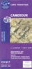
Cameroon & Gabon ITMB

Indexed, double-sided map showing on one side Cameroon at 1:1, 500, 000 and on the reverse Gabon with Equatorial Guinea at 1:950, 000, with street plans of Yaounde, Douala and Libréville.Both maps have altitude colouring with spot heights and indicate wetlands, swamps and mangrove areas. Elevation in Cameroon is shown in feet, whilst in Gabon in metres. Road network includes unpaved roads and tracks and indicates locations of petrol supplies and border crossings. National parks and protected areas are highlighted and symbols show tourist accommodation and campsites, churches and missions, various places of interest, hospitals and medical facilities, etc. Each map is indexed and has latitude and longitude lines at intervals of 1º. Basic street plans are provided for Yaounde,
Douala and Libréville.Equatorial Guinea is shown with Gabon at 1:950, 000, with Bioko Island as an inset at 1:500, 000.
RIP - This product is no longer available on our network. It was last seen on 25.09.2019

This page now acts as a permanent archive for this product. Add more information using the comments box below to ensure it can still be found by future generations.

Use our search facility to see if it is available from an alternative contributor.
  • External links may include paid for promotion
  • Availability: Out Of Stock
  • Supplier: Stanfords
  • SKU: 9781553411574
Availability: In Stock
£9.99

Product Description

Indexed, double-sided map showing on one side Cameroon at 1:1, 500, 000 & on the reverse Gabon with Equatorial Guinea at 1:950, 000, with street plans of Yaounde, Douala & Libréville. Both maps have altitude colouring with spot heights & indicate wetlands, swamps & mangrove areas. Elevation in Cameroon is shown in feet, whilst in Gabon in metres. Road network

Includes::
unpaved roads & tracks & indicates locations of petrol supplies & border crossings. National parks & protected areas are highlighted & symbols show tourist accommodation & campsites, churches & missions, various places of interest, hospitals & medical facilities, etc. Each map is indexed & has latitude & longitude lines at intervals of 1º. Basic street plans are provided for Yaounde, Douala & Libréville. Equatorial Guinea is shown with Gabon at 1:950, 000, with Bioko Island as an inset at 1:500, 000.

Reviews/Comments

Add New

Intelligent Comparison

Oooops!
We couldn't find anything!
Perhaps this product's unique.... Or perhaps we are still looking for comparisons!
Click to bump this page and we'll hurry up.

Price History

Vouchers

No voucher codes found.
Do you know a voucher code for this product or supplier? Add it to Insights for others to use.

Facebook

Jargon Buster

Metres - A unit of measure, one metre equals 100 centimetres
Cameroon - A country in Central and Western Africa.
Network - A link and communication between things. Often computers or people.
Road - a manmade lane or a path that is used to speed up travel.
Altitude - Something that can be quite high in relation to sea or ground level.
Accommodation - A room in which someone can live in, for example in a hotel

Supplier Information

Stanfords
Stanfords was established in 1853 and opened their iconic Covent Garden flagship store in 1901. They have become the top retailer of maps, travel books and accessories in the UK and arguably offer the largest selection of maps and travel books worldwide. Famous names such as Captain Robert Falcon Scott, Ranulph Fiennes and Michael Palin have purchased from Stanfords. They now have a shop in Bristol and both stores together with other venues operate a calendar of events including talks, book signings and exhibitions. As a specialist map retailer, the map selection is comprehensive and includes road maps, street maps and walking maps from worldwide destinations, as well as a selection of world atlases and wall maps. Books include travel guides and travel literature. Stanfords also stock globes, from miniatures made of blue marble to magnificent floor-standing globes. The website features a selection of interesting articles on travel topics.
Page Updated: 2023-11-12 20:15:36

Community Generated Product Tags

Oh No! The productWIKI community hasn't generated any tags for this product yet!
Menu