More From Contributor
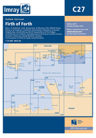
£19.95
This Imray’s series of charts for the Western Europe

Includes::
comprehensive & easy-to-use sailing charts

...
Archived Product
£19.95
Plans included: Wick Bay Helmsdale Inverness Firth Inverness Nairn Burghead Hopeman Lossiemouth Buckie Banff & Macduff Fraserburgh Peterhead Aberdeen Stonehaven Montrose Arbroath This edition has been fully updated with revised depths applied throughout, in particular at Wick Bay, Burghead, Montrose Harbour, Aberdeen & the approaches to Inverness Firth. Harbour developments are shown at Wick Bay, Peterhead & Aberdeen. ...
Archived Product
£19.95
Imray’s series of charts of Northwest Europe are comprehensive & easy-to-use sailing charts published on rip-proof, waterproof paper- ideal to be used on small tables or in cockpits. They show detailed coastline & depth information, & are constantly corrected to reflect latest information. The C Charts offer coverage for cruising on larger-size sheets; they are suitable for offshore passage making & the medium scales chosen also allow safe inshore navigation. This chart

Includes::
plans/insets of the following locations:- Whitby- River Tees- Hartlepool- Seaham- Sunderl&- River Tyne- Continuation of River Tyne to Newcastle- Blyth- Warkworth- Holy Island Harbour- Berwick- Eyemouth- Farne Islands Each chart contains insets showing local harbours annotated with symbols indicating what facilities can be found there (marinas, mooring & berth facilities, fuel, water, chandlers, etc.). Depths are shown in metres. Charts are fully updated to the latest printing date, & often include further corrections on a separate sheet. Subsequent corrections can be found on the Imray website. Positions referring to WGS84 Datum, such as most GPS readings, can be plotted directly onto these charts. Base cartography uses contours, several levels of colour shading, & spot measurements to indicate depth relative to Lowest Astronomical Tide, including distinct colour highlighting for tidally-covered l&. A large number of hatchings & markings are used to indicate coast types, salt flats, marshl&, etc. Compliant IALA ‘ System A’ buoys are clearly marked, & indications of other navigational aides such as light floats are given where possible. Lighthouses are clearly marked with arcs of visibility. A complex & comprehensive system of symbols is used to indicate all types of submerged obstructions, including wrecks, rocks, pipelines & cables, with depths where known. Flood tides, eddies races, ebb tide streams & other current information is given. A wide range of symbols indicate onshore features, anchorages, harbour details & other points of note. Danger areas, restricted areas & traffic zones are all shown.

...
Archived Product
£19.95
Plans included: Oudeschild (1:15, 000) Den Helder (1:21, 000) IJmuiden (1:35, 000) Scheveningen (1:10, 000) The 2013 edition of this chart shows full details of the new & enhanced routeing measures off the coast of the Netherlands, as implemented on 1st August 2013. ...
Archived Product
£19.95
Plans included: IJmuiden (1:35 000) Den Helder (1:21 000) West -Terschelling (1:20 000) Lauwersoog (1:15 000) Borkum Yacht Harbour (1:25 000) Norderney Approaches (1:66 000) Helgoland (1:25 000) Cuxhaven (1:12 500) Brunsbuttel (1:12 500) On this 2015 edition changes have been made to depths, windfarms, restricted areas, & oil & gas fields throughout. Changes to the North Friesland TSS, due to be implemented on the 1st June 2015, are shown. ...
Archived Product
£19.95
Plans included: Wells-next-the-Sea (1:30 000) Blakeney Harbour (1:28 000) Great Yarmouth Haven (1:10 000) Lowestoft Approaches (1:42 500) Southwold Harbour (1:12 500) Rivers Ore & Alde (1:42 500) River Deben (1:45 000) Lowestoft Harbour (1:12 000) For this 2014 edition the chart has been fully updated throughout using extensive new depth surveys. The completed Greater Gabbard wind farm is now shown. The sketch plans of Wells & Blakeney Harbour have been revised & updated. ...
Archived Product
£19.95
Plans included: Whitby (1:15 000) Scarborough (1:7500) Filey (1:20 000) Bridlington (1:20 000) River Humber (1:110 000) River Humber
-
...
Archived Product
£12.95
The Coast to Coast (C2C) guide covers the Sustrans cycle route across the UK, from Whitehaven or Workington to Tynemouth or Sunderl&, through the English Lake District, the Eden Valley & the Pennines. The C2C is the UK`s most popular cycle challenge, whether undertaken over a single day or a full week, & has become a modern classic. It takes in some of northern England`s finest scenery on cycle paths, forest tracks & minor roads, with off-road options & a selection of taster day rides also described here. The Hadrian`s Wall & Reivers` Way cycle routes also offer great options for a return trip. The route is described here as a 5-day route, from west to east, itineraries are also included for 2, 3 & 4-day options, along with sections on cycle maintenance & puncture-mending & riding the route from east to west. Detailed profiles & OS mapping illustrate each stage. ...
Archived Product
£19.95
Plans included: Lymington River (1:17 500) River Hamble (1:20 000) Bembridge Harbour (1:20 000) Continuation of Southampton Water (1:45 000) On this 2018 edition the latest depth surveys have been applied. Completed works on the Capital Dredge Programme are included. The latest 2018 racing buoy positions are shown. There has been general updating throughout. ...
Archived Product
£19.95
Plans included: Dunkerque (1:25, 000) Nieuwpoort (1:30, 000) Oostende (1:20, 000) Blankenberge (1:10, 000) Zeebrugge (1:35, 000) Breskens (1:12, 500) Vlissingen (1:20, 000) This second 2013 edition of Imray`s best-selling chart of the southern North Sea incorporates full details of the routeing measures around Hook of Holland & at North Hinder, which are due to be implemented on 1st August. The completed Greater Gabbard windfarms are shown, as are windfarm developments at Thorntonbank. Revised depths have been used off the coast of Suffolk & along the Dutch coast between Europoort & Walcheren. For this chart, Peter Cumberlidge has selected over 70 strategically placed waypoints & produced safe recommended routes across the southern North Sea & into the Thames Estuary as far as the Suffolk rivers. Presented as a clear blue overprint, these waypoints & routes are invaluable for negotiating the complex busy shipping lanes & provide users of chart C30 a convenient facility for passage planning. ...
Archived Product

C27 Firth Of Forth

Plans included: St Andrews (1:7, 500) Crail (1:7, 500) Anstruther (1:7, 500) St Monans (1:7, 500) Elie (1:10, 000) Methil Docks (1:11, 000) Pettycur & Kinghorn (1:17, 500) Inchkeith (1:25, 000) Burntisland (1:20, 000) Aberdour (1:12, 500) Inchcolm (1:15, 000) Dalgety Bay (1:15, 000) Inverkeithing (1:15, 000) North Queensferry & Port Edgar (1:20, 000) Charlestown & Limekilns (1:15, 000) Grangemouth and Entrance to River Carron (1:17, 500) Granton (1:12, 500) Fisherrow (1:12, 500) North Berwick (1:7, 500) Dunbar (1:7, 500) Continuation to Forth and Clyde Canal Entrance (1:17, 500) On this 2013 edition, the latest known depths have been applied throughout the main chart and on the plans of Grangemouth and Granton. Harbour developments are shown at Granton.The chart has also been reschemed in
the following ways: the extents of the main chart have been adjusted for a better fit on the printed page; the plans of Pittenweem and Kirkcaldy have been removed; a new plan `North Queensferry & Port Edgar` combines the previous plans of North Queensferry and Port Edgar onto a single plan, whilst also providing better coverage of the Forth Bridges; and the sketch plans of Crail, Anstruthur, St Monans and Dunbar have all been redrawn for a more accurate fit in relation to WGS84 datum.
RIP - This product is no longer available on our network. It was last seen on 25.09.2019

This page now acts as a permanent archive for this product. Add more information using the comments box below to ensure it can still be found by future generations.

Use our search facility to see if it is available from an alternative contributor.
  • Availability: Out Of Stock
  • Supplier: Stanfords
  • SKU: 9781786790590
Availability: In Stock
£19.95

Product Description

Plans included: St Andrews (1:7, 500) Crail (1:7, 500) Anstruther (1:7, 500) St Monans (1:7, 500) Elie (1:10, 000) Methil Docks (1:11, 000) Pettycur & Kinghorn (1:17, 500) Inchkeith (1:25, 000) Burntisland (1:20, 000) Aberdour (1:12, 500) Inchcolm (1:15, 000) Dalgety Bay (1:15, 000) Inverkeithing (1:15, 000) North Queensferry & Port Edgar (1:20, 000) Charlestown & Limekilns (1:15, 000) Grangemouth & Entrance to River Carron (1:17, 500) Granton (1:12, 500) Fisherrow (1:12, 500) North Berwick (1:7, 500) Dunbar (1:7, 500) Continuation to Forth & Clyde Canal Entrance (1:17, 500) On this 2013 edition, the latest known depths have been applied throughout the main chart & on the plans of Grangemouth & Granton. Harbour developments are shown at Granton. The chart has also been reschemed in the following ways: the extents of the main chart have been adjusted for a better fit on the printed page; the plans of Pittenweem & Kirkcaldy have been removed; a new plan ` North Queensferry & Port Edgar` combines the previous plans of North Queensferry & Port Edgar onto a single plan, whilst also providing better coverage of the Forth Bridges; & the sketch plans of Crail, Anstruthur, St Monans & Dunbar have all been redrawn for a more accurate fit in relation to WGS84 datum.

Reviews/Comments

Add New

Intelligent Comparison

Oooops!
We couldn't find anything!
Perhaps this product's unique.... Or perhaps we are still looking for comparisons!
Click to bump this page and we'll hurry up.

Price History

Vouchers

No voucher codes found.
Do you know a voucher code for this product or supplier? Add it to Insights for others to use.

Facebook

Jargon Buster

Accurate - A measurement of precision when all elements are correct.

Supplier Information

Stanfords
Stanfords was established in 1853 and opened their iconic Covent Garden flagship store in 1901. They have become the top retailer of maps, travel books and accessories in the UK and arguably offer the largest selection of maps and travel books worldwide. Famous names such as Captain Robert Falcon Scott, Ranulph Fiennes and Michael Palin have purchased from Stanfords. They now have a shop in Bristol and both stores together with other venues operate a calendar of events including talks, book signings and exhibitions. As a specialist map retailer, the map selection is comprehensive and includes road maps, street maps and walking maps from worldwide destinations, as well as a selection of world atlases and wall maps. Books include travel guides and travel literature. Stanfords also stock globes, from miniatures made of blue marble to magnificent floor-standing globes. The website features a selection of interesting articles on travel topics.
Page Updated: 2023-11-12 20:15:36

Community Generated Product Tags

Oh No! The productWIKI community hasn't generated any tags for this product yet!
Menu