
 United Kingdom
 France
 Germany
 Netherlands
 Sweden
 USA
USA
 Italy
Italy
 Spain
Spain
More From Contributor


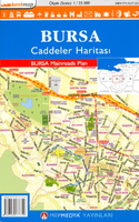
Bursa Main Roads Plan
Bursa Main Roads Plan at 1:25, 000 from Mepmedya is an indexed, double-sided road map of the area surrounding the city. Shows main transport routes and many places of interest, and includes insets of Uludag University and Kestel. *Map legend also in English.* Major and secondary roads and main streets are named; and many more streets are shown but not named. The light metro and cable car systems are displayed, and local bus stations and airports are marked.Local districts are named and demarcated, and many places of interest are annotated on the map. These include: museums and parks; public buildings, shops, emergency services and university buildings; and sports and entertainment venues.The map coverage appears on two side of the sheet, with a north-south split at a point just
south of Bursa airport (no overlap). It covers the central areas of Osmangazi and Yildirim Districts in Bursa Province.Includes an enlarged inset of the city centre (scale unknown), with greater detail of transport routes, local districts and numerous places of interest.An index appears on the map, listing streetnames, and a small inset shows the location of Bursa within its province.
south of Bursa airport (no overlap). It covers the central areas of Osmangazi and Yildirim Districts in Bursa Province.Includes an enlarged inset of the city centre (scale unknown), with greater detail of transport routes, local districts and numerous places of interest.An index appears on the map, listing streetnames, and a small inset shows the location of Bursa within its province.

Product Description
Reviews/Comments
Add New
Intelligent Comparison
Archived Product
Ankara Main Roads Plan Stanfords
£7.95
Archived Product
Izmir Main Roads Plan Stanfords
£7.95
Archived Product
Konya Main Roads Plan Stanfords
£8.99
Archived Product
Antalya Main Roads Plan Stanfords
£7.99
Archived Product

Gaziantep Main Roads Plan Stanfords
£7.99
Archived Product

Mersin & Tarsus Main Roads Plan Stanfords
£8.99
Vouchers
No voucher codes found.
Do you know a voucher code for this product or supplier? Add it to Insights for others to use.
Do you know a voucher code for this product or supplier? Add it to Insights for others to use.
 Denmark