More From Contributor

£3.50
Bredbury West & Brinnington in 1907 in a fascinating series of reproductions of old Ordnance Survey plans in the Alan Godfrey Editions, ideal for anyone interested in the history of their neighbourhood or family. The map covers a semi-rural area on the edge of Stockport & Manchester. The western part of Bredbury is in the south-eastern corner of the map, including Bredbury Steel Works, Bredbury station, foundry, Stockport Road with tramway, railway junctions, Alvanley House, etc. The map then extends westward to Brinnington Hall & the GCR Portwood or Brinnington Branch. Other features include Ark Ring Spinning Mill, Brinnington Brick Works, Woodside Brick Works & Lingard Lane Collieries. On the reverse are 1896 directories for both Bredbury & Brinnington. About the Alan Godfrey Editions of the 25” OS Series: Selected towns in Great Britain & Ireland are covered by maps showing the extent of urban development in the last decades of the 19th & early 20th century. The plans have been taken from the Ordnance Survey mapping & reprinted at about 15 inches to one mile (1:4, 340). On the reverse most maps have historical notes & many also include extracts from contemporary directories. Most maps cover about one mile (1.6kms) north/south, one & a half miles (2.4kms) across; adjoining sheets can be combined to provide wider coverage.FOR MORE INFORMATION & A COMPLETE LIST OF ALL AVAILABLE TITLES PLEASE CLICK ON THE SERIES LINK. ...
Archived Product
£16.99
Sverigeserien is an outdoor map series consisting of 116 sheets with coverage of southern & central Sweden & the northern coastline. The map is suitable for outdoor activities such as hiking, excursions, trail running, hunting, fishing, riding, cycling, mountain biking, paddling, skating & much more. Every sheet covers an area of 45x 68km. These topographical maps in scale 1:50 000 contain all the information needed for outdoor activities: Terrain information, hiking trails, illuminated tracks, camping, shelters, golf courses, leisure baths, historical remains, roads in different categories, railway lines & much more. Easy to read topography with contour lines, vertical interval 5 m. Sverigeserien is a high-quality map series & is durable for frequent use! Updated content with map data from Lantmäteriet (National Land Survey of Sweden) & printed on Polyart which is water & tear resistant. This means that the map can be folded repeatedly without breaking & can withstand the challenging weather in Sweden during both winter & summer. Legend is in Swedish, English & German. ...
Archived Product
£15.00
Breddos Tacos revels in being a non-traditional but incredibly inventive taco cookbook with the over 75 recipes taking flavor combinations & ingredients from cuisines from almost every continent in the world, in order to create the ultimate combination of one perfectly cooked taco piled high with complex layers of flavouring. The recipes cover tacos, tostadas & plates & are divided into beef, poultry, pig, seafood, lamb & vegetables, featuring dishes such as Barbecoa beef cheeks, Yucatan Chicken with mango habanero sauce, Green Chorizo & duck egg & Scallop Aguachile. However, the breddos recipes don`t justcover tacos (although most of the recipes can be piled onto taco-esque `edible plates`) as they also offer street food staples such as the Iberico hamcheeseburger & Yucatan spatchcock chicken with Dong`s flatbreads. The guys also share the breddos story to ultimate taco-dom fame; detailing their epic taco-fuelled Fear & Loathing in Las Vegas-esque road-trip around Mexico, Miami, the Deep South & Los Angeles devised solely to discover the greatest flavor combinations in all America
- on a taco. This book will sate even the greatest taco fanatic whilst also revolutionizing the ingredients & dishes you can create from the miniature taco hero.
...
Archived Product
£9.95
An exciting sailing narrative evoking a vivid picture of Bob Robert`s time in the Thames sailing barge Cambria. In this book he introduces some of the colourful characters that he met over the years in those trading days. Then he became part owner of the Whitstable fishing vessel Quartette & made passage to Rio de Janeiro encountering various adventures on the voyage. Quartette was sold in Port of Spain & Bob, out of funds, was employed as mate in a rum schooner. He returned to continue carrying cargoes be barge with the rigours of the `big freeze` in 1963. ...
Archived Product
£5.50
Indexed street plan of Bregenz extending north along the Bodensee coast to Lochau & Unter Hochsteg. Detail

Includes::


...
Archived Product
£9.99
Bregenz
- Bregenzerwald area of the Austrian Alps presented at 1:50, 000 in a series of contoured & GPS compatible outdoor leisure
...
Archived Product
£12.99
Bregenz, map No. 218, in the standard topographic survey of Switzerland at 1:50, 000 from Swisstopo, i.e. without the special overprint highlighting walking trails, local bus stops, etc, presented in Swisstopo’s hiking editions of the 50K survey. The map covers mainly the Austrian side of the border, plus the Bavarian side of Lake Constance with Lindau. Highly regarded for their superb use of graphic relief & hill shading, the maps give an almost 3-D picture of Switzerland`s mountainous terrain. Contours are at 20m intervals. All the maps have a 1-km grid with the Swiss national coordinates. This standard version of the 50K survey covers the whole country on 78 small format sheets, with special larger format maps published for several popular tourist destinations. Small format sheets cover an area of 35 x 24 km (21 x 15 miles approx) & have map legend in the language of the area covered by the map. The special larger sheets cover 50 x 35 km (31 x 22 miles approx) & have no map legend, but a separate leaflet can be provided instead.PLEASE NOTE: the hiking editions of the 1:50, 000 Swisstopo survey are listed on our website in a separate series. ...
Archived Product
£12.99
Bregenzerwald
- Bregenz
- Feldkirch
- Gr. Walsertal area of the Tyrol at 1:35, 000 on a GPS compatible, double-sided map


...
Archived Product
£9.50
Map No. 2, Bregenzerwald
- Westallgäu, with a panorama map on the reverse, in a series of hiking maps from Kompass providing
...
Archived Product
£23.99
Breheimen area in Norway in a series of GPS compatible recreational Turkart maps at 1:100, 000 with cartography from Norway’s topographic survey & additional tourist information. Contours lines are drawn at 20m intervals. The overprint varies from title to title, but

Includes::
local footpaths, in some cases distinguishing between easy & more difficult trails, as well as mountain huts & campsites. Many titles also indicate cycle or ski routes, other accommodation possibilities, sport & recreational facilities, including alpine skiing slopes, places of interest, etc. The maps have a UTM grid & margin ticks giving latitude & longitude. Map legend

Includes::
English. Several titles have on the reverse additional tourist information, although in most cases in Norwegian only. To see the list of Turkart maps at 1:100, 000 & links to Turkart series at 25K, 50K & Hiking Sets please click on the series link above.


...
Archived Product

Bregenz F&B

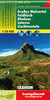
Indexed street plan of Bregenz extending north along the Bodensee coast to Lochau and Unter Hochsteg. Detail includes pedestrianised areas, railways, bus routes and cycle paths. Notable buildings are highlighted in red, and symbols indicate post offices, hostels, campsites and car parks.On the reverse is a 1:50, 000 contoured map of the Bregenzerwald region to the south-east of the town, as far as Bezau & Winterstaude. Roads, railways, ski-lifts and cable cars are shown, along with ski trails, cycle paths, and walking routes including the E4 and E5. Additional symbols show landmarks and tourist features eg. hostels, mountain cabins, churches, ruins, spas, bus stops, etc.
RIP - This product is no longer available on our network. It was last seen on 25.09.2019

This page now acts as a permanent archive for this product. Add more information using the comments box below to ensure it can still be found by future generations.

Use our search facility to see if it is available from an alternative contributor.
  • Availability: Out Of Stock
  • Supplier: Stanfords
  • SKU: 9783707917093
Availability: In Stock
£9.99

Product Description

Indexed street plan of Bregenz extending north along the Bodensee coast to Lochau & Unter Hochsteg. Detail

Includes::
pedestrianised areas, railways, bus routes & cycle paths. Notable buildings are highlighted in red, & symbols indicate post offices, hostels, campsites & car parks. On the reverse is a 1:50, 000 contoured map of the Bregenzerwald region to the south-east of the town, as far as Bezau & Winterstaude. Roads, railways, ski-lifts & cable cars are shown, along with ski trails, cycle paths, & walking routes including the E4 & E5. Additional symbols show landmarks & tourist features eg. hostels, mountain cabins, churches, ruins, spas, bus stops, etc.

Reviews/Comments

Add New

Intelligent Comparison

Oooops!
We couldn't find anything!
Perhaps this product's unique.... Or perhaps we are still looking for comparisons!
Click to bump this page and we'll hurry up.

Price History

Vouchers

No voucher codes found.
Do you know a voucher code for this product or supplier? Add it to Insights for others to use.

Facebook

Jargon Buster

Cable - A series of wires bonded to form a single thread
Red - One of the three primary colours
Railways - A set of tracks that have been laid for the purpose of trains to travel up and down them
Car - A machine used for transport which runs on roads

Supplier Information

Stanfords
Stanfords was established in 1853 and opened their iconic Covent Garden flagship store in 1901. They have become the top retailer of maps, travel books and accessories in the UK and arguably offer the largest selection of maps and travel books worldwide. Famous names such as Captain Robert Falcon Scott, Ranulph Fiennes and Michael Palin have purchased from Stanfords. They now have a shop in Bristol and both stores together with other venues operate a calendar of events including talks, book signings and exhibitions. As a specialist map retailer, the map selection is comprehensive and includes road maps, street maps and walking maps from worldwide destinations, as well as a selection of world atlases and wall maps. Books include travel guides and travel literature. Stanfords also stock globes, from miniatures made of blue marble to magnificent floor-standing globes. The website features a selection of interesting articles on travel topics.
Page Updated: 2023-11-12 20:15:36

Community Generated Product Tags

Oh No! The productWIKI community hasn't generated any tags for this product yet!
Menu