More From Contributor

£11.99
This Bradt guide to Bratislava combines history with hedonism. Maps, walking tours, historical perspectives & hotels, restaurants, cafes & pubs are all covered. In addition, it features detailed information on shopping, sports, gardens & parks. Not only does it include out-of-town ideas, it is written in an engaging & colourful style that sets out very deliberately to entertain as well as inform. This edition is thoroughly updated to include the vast number of new first class & boutique hotels, restaurants, bars & cafes. It also offers an innovative tram map & guidance on city transport, an updated event calendar, & objective & practical advice on buying property in Bratislava. Straying out of the city itself, it also covers Kosice, 2013 European City of Culture. ...
Archived Product
£6.99
This is the savvy city breakers' pocket guide to seeing & doing more in the Slovakian capital
- with a fun-seeking & cost-conscious
...
Archived Product
£4.99
Central Bratislava in a series of handy pocket street plans from Freytag & Berndt. Each map is laminated, so waterproof & tear-resistant, & highlights the publishers’ recommendations of five best choices in five categories: shopping, restaurants & cafes, culture, nightlife & sights. On one side is an indexed street plan annotated with colour-coded markers highlighting the publishers’ recommendations, all listed on the reverse of the map with brief notes in several languages. In larger cities the plans cover only the central districts. Also provided are a small road map of the city’s environs, if appropriate a diagram of the metro network, & a Fact Box with phone numbers for tourist offices, car hire & emergency services. Map legend & notes on the recommendations include English. To see other titles is this series please click on the series link. ...
Archived Product
£9.99
Indexed street plan of the Slovak capital & the surrounding outer suburbs. The map shows public transport, places of interest, etc. An enlargement shows the city centre in greater detail. The plan also

Includes::
a small road map of the area between Bratislava & Vienna. Map legend

Includes::
English.


...
Archived Product
£6.99
Bratislava on an indexed street plan at 1:16, 000 with an enlargement of its historic centre highlighting important buildings by small drawings, a map of the capital’s environs, plus brief descriptions of main sights. Cartography is by Shocart
- Slovak subsidiary of Freytag & Berndt. On one side is a street plan of Bratislava with its outer suburbs, including the city’s M. R. Štefánik International Airport. Tram, trolleybus & bus lines are shown with stops & line numbers. For divers the plan indicates one way & pedestrinized streets, car parks & locations of petrol stations. Symbols mark various facilities & places of interest. Street index is on the reverse, together with an inset presenting the city’s historic centre in much greater detail, highlighting main sights, selected hotels & restaurants, etc. The reverse side also provides a contoured map at 1:100, 000 of Bratislava’s environs, highlighting numerous hiking trails in the Male Karpaty hills north of the city. Also provided are brief descriptions of main sights in the city. Map legend & the descriptions include English.
...
Archived Product
£15.00
Talk of the town: A landmark in urban mapping More than four centuries on from its first publication, discover one of the jewels of urban cartography & civic studies. This quality reprint

Includes::
all 363 colour plates from the Civitates orbis terrarum, a magnificent collection of town map engravings, produced between 1572 & 1617. Featuring plans, bird`s-eye views, & maps for all major cities in Europe, plus important urban centers in Asia, Africa, & Latin America, this masterwork in urban mapping gives us a comprehensive view of city life at the turn of the 17th century. It was edited & annotated by theologian & publisher Georg Braun & largely engraved by Franz Hogenberg, but also involved over a hundred different artists & cartographers who contributed not only town views, but additional elements, such as figures in local dress, courtroom scenes, & topographical details, to help convey the situation, commercial power, & political influence of each city. Taschen`s reprint contextualises the plates with selected extracts from Braun`s original texts on the history & significance of each urban center as well as detailed commentaries to place each city map in its cartographical & cultural context.

...
Archived Product
£49.99
More than four centuries on from its first publication, discover one of the jewels of urban cartography & civic studies. This quality reprint

Includes::
the most enchanting color plates from the Civitates orbis terrarum, a magnificent collection of town map engravings, produced between 1572 & 1617. Featuring plans, bird`s-eye views, & maps for all major cities in Europe, plus important urban centers in Asia, Africa, & Latin America, this masterwork in urban mapping gives us a comprehensive view of city life at the turn of the 17th century. It was edited & annotated by theologian & publisher Georg Braun & largely engraved by Franz Hogenberg, but also involved over a hundred different artists & cartographers who contributed not only town views, but additional elements, such as figures in local dress, courtroom scenes, & topographical details, to help convey the situation, commercial power, & political influence of each city.TASCHEN`s reprint contextualizes the plates with selected extracts from Braun`s original texts on the history & significance of each urban center as well as detailed commentaries to place each city map in its cartographical & cultural context.

...
Archived Product
£5.50
ADAC, Germany's equivalent of the British Automobile Association publishes an extensive series of street plans which provide detailed high-quality mapping of all the major towns & cities, including their outer suburbs. The plans name all the individual streets & indicate all the main landmarks & public buildings. All public transport facilities are shown: buses, trams, underground & overland rail lines. One way streets & car parks are indicated. Plans of larger cities include an enlargement for the city centre. The plans also show the administrative & postal divisions & have an extensive street index which, where appropriate, shows individual postal codes for each street. On the reverse, each plan has a road map at 1:100, 000, covering a very wide area around the city. Map legend

Includes::
English.

...
Archived Product
£10.99
Braunschweig & its Environs on a waterproof, tear-resistant, GPS compatible cycling map at 1:75, 000 from the ADFC (Allgemeiner Deutscher Fahrrad-Club
- the official German cycling federation), in a series of maps with extensive overprint for long-distance & local cycling routes. GPS waypoints, route profiles, details of online links for information about accommodation etc. are also provided. Maps included in this series are contoured & the interval varies according to the type of the terrain. Steep sections are annotated with gradient markings. Colouring and/or graphics show various types of landscape: woods, vineyards, etc. An overprint highlights both the national long-distance cycling routes & the shorter local cycling trails, each clearly identified by a symbol and/or an abbreviation of its name. Sections with heavy traffic and/or poor road surface are clearly marked. Symbols indicate various facilities, such as railway stations with cycle hire, cycle repair shops, campsites, youth hostels, shelters, country restaurants/bars, sport & leisure facilities. Maps have a UTM grid for measuring distances & for determining location using GPS device & they are printed on weather resistant & tear-resistant paper. Each map covers an area of Approx. 110 x 100 km & the map legend is in German only. To see all the titles in this series please click on the series link.
...
Archived Product
£7.99
Falk, one of Germany`s leading publishers of street plans, produce their town plans in two different formats. Falk Extra plans are folded in a standard way, where the whole map can be opened to view the entire area it covers. For larger cities, the same mapping is also published with a special folding system designed to show only a small section of the map at one time. The whole map can be opened but it will be cut in several places. Many find these street plans very user-friendly & easier to handle than conventional maps. The plans, which cover towns with their outer suburbs, indicate main landmarks & public buildings & show all the public transport facilities, one way streets & car parks. Plans of lager cities include a separate map of the town centre at a more detailed scale & a diagram of the underground & the suburban rail network. The plans also show the postal divisions & have an extensive street index which, where appropriate, shows individual postal codes for each street. Map legend

Includes::
English. Falk Extra plans also include on the reverse a road map of the surrounding area.

...
Archived Product

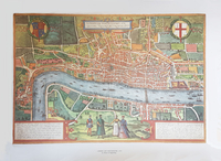
Braun And Hogenberg`s London Map 1572

This town plan of London and Westminster was first produced in 1572 by Braun and Hogenberg as part of their atlas of city views called `Civitates Orbis Terrarum`. This six volume work was issued between 1572 and 1618 and contained more than 500 city plans. Reproduced by Wychwood Editions.
RIP - This product is no longer available on our network. It was last seen on 25.09.2019

This page now acts as a permanent archive for this product. Add more information using the comments box below to ensure it can still be found by future generations.

Use our search facility to see if it is available from an alternative contributor.
  • Availability: Out Of Stock
  • Supplier: Stanfords
  • SKU: 9781879856752
Availability: In Stock
£8.99

Product Description

This town plan of London & Westminster was first produced in 1572 by Braun & Hogenberg as part of their atlas of city views called ` Civitates Orbis Terrarum`. This six volume work was issued between 1572 & 1618 & contained more than 500 city plans. Reproduced by Wychwood Editions.

Reviews/Comments

Add New

Intelligent Comparison

Oooops!
We couldn't find anything!
Perhaps this product's unique.... Or perhaps we are still looking for comparisons!
Click to bump this page and we'll hurry up.

Price History

Vouchers

No voucher codes found.
Do you know a voucher code for this product or supplier? Add it to Insights for others to use.

Facebook

Jargon Buster

Supplier Information

Stanfords
Stanfords was established in 1853 and opened their iconic Covent Garden flagship store in 1901. They have become the top retailer of maps, travel books and accessories in the UK and arguably offer the largest selection of maps and travel books worldwide. Famous names such as Captain Robert Falcon Scott, Ranulph Fiennes and Michael Palin have purchased from Stanfords. They now have a shop in Bristol and both stores together with other venues operate a calendar of events including talks, book signings and exhibitions. As a specialist map retailer, the map selection is comprehensive and includes road maps, street maps and walking maps from worldwide destinations, as well as a selection of world atlases and wall maps. Books include travel guides and travel literature. Stanfords also stock globes, from miniatures made of blue marble to magnificent floor-standing globes. The website features a selection of interesting articles on travel topics.
Page Updated: 2023-11-12 20:15:36

Community Generated Product Tags

Oh No! The productWIKI community hasn't generated any tags for this product yet!
Menu