More From Contributor
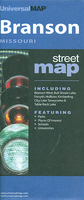
£15.99
Brandenburg: Historic Town Centres Cycle Tours Part 2 guide from Verlag Esterbauer covering three circular tours totaling 1000 kilometres in the southern half of the state, along the Havel, through the remote landscapes between the Elbe & the Elster, in the Lusatian Lake landscape of the former mining area & in the Spreewald. In addition to Potsdam & Brandenburg, the routes take in several smaller historic towns with restored historic city centres. The routes & their variants are shown on maps at 1:50, 000. Extensive information is conveyed by symbols, indicating road surface, campsites & other accommodation, repair workshops, recreational facilities, places of interest, etc. A list of various types of accommodation facilities is included.IMPORTANT
- PLEASE NOTE BEFORE ORDERING
- ALL THE TEXT IN THIS TITLE IS GERMAN ONLY. MAP LEGEND

Includes::
ENGLISH (please see our sample image) & the information provided on the maps is sufficient to use this title without any knowledge of German.ABOUT THE BIKELINE SERIES: all the titles have been meticulously researched & are highly regarded in their native Germany. Most titles, as indicated in their individual descriptions, also include a separate section listing selected accommodation, from hotels to campsites, youth hostels & rooms in private houses, all with addresses, telephone numbers & price range. Information on towns along each route

Includes::
a list of places of interest, with opening hours, etc. Several of the guides also have street plans. To see the list of other titles in the Bikeline series please click on the series link.


...
Archived Product
£9.99
Brandes, a painter living in Nazi-occupied Paris has a tough decision to make: Goring has taken away all his artwork & asked him to hand over his Lucas Cranach painting, a family heirloom. If he relinquishes the Cranach, he will recover all his pictures in exchange. If he refuses, he will never get them back. In his search for a solution, Brandes reflects on the deeper meaning of things & their true values. ...
Archived Product
£9.99
Brandnertal
- Nenzinger Himmel
- Rätikon area of the Austrian Alps presented at 1:35, 000 in a series of contoured & GPS compatible

...
Archived Product
£3.50
5 Brandon in 1903 in a fascinating series of reproductions of old Ordnance Survey plans in the Alan Godfrey Editions, ideal for anyone interested in the history of their neighbourhood or family. The map straddles the Suffolk border & is also Norfolk Sheet 92.16. It covers the town of Brandon in good detail, & features here include High Street, Market Hill, London Road, Thetford Road, Bury Road, Gashouse Drove, old limekilns, fur manufactory & St Peter`s church. Town Street, Brandon Hall & Foord House are in the south-western corner. The Little Ouse River runs through the map & north of this is the Great Eastern Railway with Brandon station. On the reverse is a directory of Brandon in 1896. About the Alan Godfrey Editions of the 25” OS Series: Selected towns in Great Britain & Ireland are covered by maps showing the extent of urban development in the last decades of the 19th & early 20th century. The plans have been taken from the Ordnance Survey mapping & reprinted at about 15 inches to one mile (1:4, 340). On the reverse most maps have historical notes & many also include extracts from contemporary directories. Most maps cover about one mile (1.6kms) north/south, one & a half miles (2.4kms) across; adjoining sheets can be combined to provide wider coverage.FOR MORE INFORMATION & A COMPLETE LIST OF ALL AVAILABLE TITLES PLEASE CLICK ON THE SERIES LINK. ...
Archived Product
£12.50
Brandon Mountain on the Dingle Peninsula at 1:25, 000 from the Ordnance Survey of Irel&, printed on light, waterproof & tear-resistant plastic paper & presenting hiking routes on a very clear picture of the area’s topography. Cartography is an enlargement of the country’s topographic survey at 1:50, 000, with contour lines 10m intervals, less densely packed here, altitude colouring & numerous additional spot heights, plus graphics for different types of woodl&. Place names, where appropriate, are shown in their English & Irish versions. The map highlights the course of the Dingle Way long-distance footpath, as well as local waymarked or unmarked hiking trails, including the Pilgrims Routes. Symbols indicate youth hostels, car parks, view points, etc. Irish national grid lines are drawn at 1km intervals. ...
Archived Product
£7.99
Double-sided, indexed street plan of Brantford, Stratford & Woodstock, including Simcoe Delhi, Paris, Port Dover, St. Marys, & Waterford. Street plans from the Map Art / Canadian Cartographics Corporation / JDM Géo publishing group are usually produced at scales around 1:25, 000 to 1:35, 000 with smaller towns often shown at more detailed scales. All plans have street indexes. Plans of larges cities usually include an enlargement for the downtown area. Plans grouping together several smaller towns often have an overview map showing the whole of the relevant region. The plans have colouring to indicate commercial, institutional or industrial use, etc. Main traffic arteries are highlighted & one way streets are marked. A range of symbols shows, as appropriate, parking facilities, bus terminals, metro and/or railway stations, various public facilities & services, places of interest, recreational centres, etc. Map legends for cities & towns in the French speaking part of the country are sometimes in French only. To see the list of currently available Canadian street plans & pocket atlases form the Map Art / Canadian Cartographics Corporation / JDM Géo publishing group, including waterproof & tear-resistant Fast Track titles, please click on the series link. ...
Archived Product
£5.95
Brasilia in the Wallpaper* City Guide series, published by Phaidon & encompassing a collection of pocket-size guides dedicated to the best design elements in major cities. Compiled by experts at the Wallpaper* magazine, the guides are widely recognized for appealing to design-conscious travellers & are aimed at those interested in art, design & architecture. Each guide identifies the best bars, restaurants, hotels, places to shop, leisure activities & excursions with a unique emphasis on the finest examples of unusual architecture & design. Each Wallpaper* City Guide has the same layout, with separate tabs allowing readers & travellers to access individual sections easily. The tabs consist of Landmarks, Hotels, 24 Hours, Urban Life, Architour, Shopping, Sports & Escapes. High quality colour photographs appear alongside brief descriptions of each hotel, bar or attraction, highlighting distinctive & unusual styles of architecture & design. Extra pages are provided at the back of each guide, allowing readers to record their own notes & sketches. ...
Archived Product
£11.99
The coast of southern Brazil on a map from the Argentinian publishers de Dios designed to highlight the region’s numerous beaches, with more detailed enlargements for the six most visited areas, classification according to their character, recommendations for accommodation, etc. On one side is a map of the whole region, extending from the Uruguay border north beyond Vitória, so including Rio, São Paolo, Belo Horizonte & the Iguaçu Falls. The map shows only main roads, indicates border crossings from Uruguay, Argentina & Paraguay (also listed on an accompanying panel) & highlights numerous beaches, most annotated with brief notes. Also marked is a selection of places of interest further inl&. The map has an index listing both the beaches & other locations shown on it. On the reverse the region’s six most visited areas, as indicated on the main map, are presented in greater detail: Florianópolis & Ilha de Santa Catarina, Bombinhas / Bombas, Armaçao dos Búzios, Garopaba / Praia do Rosa, Camboríu, & Costa Verde. The map

Includes::
a list of beaches grouped according their character: for families, for youth scene, for sporting activities, nudist, romantic or with charming accommodation, unspoilt, unmissable, etc. Also provided are web addresses of recommended accommodation & of other useful organizations, plus distance & climate charts. All the text is in Spanish only.

...
Archived Product
£6.50
Handy size street map with contours to show the topography & an enlargement for the town centre. Notable buildings & places of interest are highlighted. A range of symbols denotes many specific features e.g. hotels & campsites, restaurants, markets, filling stations, museums, car parks, etc. Many locations are numbered & listed on the reverse with the street index.A larger scale inset shows the city centre at 1:7, 500. Other insets show an overview of the region with access to the town at 1:180, 000, a street map of Stupini at 1:30, 000, & a plan of the Poiana Brasov area at 1:15, 000. Map legend

Includes::
English.

...
Archived Product
£7.99
Romanian towns of Brasov & Târgu Mures on a double-sided map from the Budapest-based Cartographia. Each town is shown with an enlargement of its central area, an index including lists of sights & facilities, plus a small road map of the surrounding region. On one side is a plan of Brasov at 1:15, 000; insets at reduced scales extend coverage to include Poiana Brasov & Stupini. On the reverse Târgu Mures is presented at 1:12, 000, with a smaller scale inset extending coverage to include Besa. Both plans highlight main traffic arteries, name important buildings & places of interest, & indicate various facilities including selected tourist accommodation, campsites, car parks & petrol stations, etc. Unusually for street plans, the base map has contours at 10m intervals & shows walks in the surrounding parkland & woodlands. Each town has an index of both streets & important buildings / sights. Map legend

Includes::
English.

...
Archived Product

Branson, MO

Branson in Missouri in a series of indexed street plans of US cities from UniversalMAP. On one side are street plans of Branson and Branson West, and on the reverse Kimberling City and Forsyth, also provided are road maps of the environs of these towns and of a wider area to the north including Springfield. Unlike most of UniversalMAP street plans this title does not indicate zip codes.Coverage includes Bull Shoals Lake, Hollister, Taneycomo and Table Rock Lake.
RIP - This product is no longer available on our network. It was last seen on 25.09.2019

This page now acts as a permanent archive for this product. Add more information using the comments box below to ensure it can still be found by future generations.

Use our search facility to see if it is available from an alternative contributor.
  • External links may include paid for promotion
  • Availability: Out Of Stock
  • Supplier: Stanfords
  • SKU: 9780762562367
Availability: In Stock
£5.99

Product Description

Branson in Missouri in a series of indexed street plans of US cities from Universal MAP. On one side are street plans of Branson & Branson West, & on the reverse Kimberling City & Forsyth, also provided are road maps of the environs of these towns & of a wider area to the north including Springfield. Unlike most of Universal MAP street plans this title does not indicate zip codes. Coverage

Includes::
Bull Shoals Lake, Hollister, Taneycomo & Table Rock Lake.

Reviews/Comments

Add New

Intelligent Comparison

Oooops!
We couldn't find anything!
Perhaps this product's unique.... Or perhaps we are still looking for comparisons!
Click to bump this page and we'll hurry up.

Price History

Vouchers

No voucher codes found.
Do you know a voucher code for this product or supplier? Add it to Insights for others to use.

Facebook

Jargon Buster

ZIP - A device (Usualy Metal) used for temporarily attaching two pieces of fabric together
Road - a manmade lane or a path that is used to speed up travel.
Zip - A Fastening which can open and close to get inside.

Supplier Information

Stanfords
Stanfords was established in 1853 and opened their iconic Covent Garden flagship store in 1901. They have become the top retailer of maps, travel books and accessories in the UK and arguably offer the largest selection of maps and travel books worldwide. Famous names such as Captain Robert Falcon Scott, Ranulph Fiennes and Michael Palin have purchased from Stanfords. They now have a shop in Bristol and both stores together with other venues operate a calendar of events including talks, book signings and exhibitions. As a specialist map retailer, the map selection is comprehensive and includes road maps, street maps and walking maps from worldwide destinations, as well as a selection of world atlases and wall maps. Books include travel guides and travel literature. Stanfords also stock globes, from miniatures made of blue marble to magnificent floor-standing globes. The website features a selection of interesting articles on travel topics.
Page Updated: 2023-11-12 20:15:36

Community Generated Product Tags

Oh No! The productWIKI community hasn't generated any tags for this product yet!
Menu