
 United Kingdom
 France
 Germany
 Netherlands
 Sweden
 USA
USA
 Italy
Italy
 Spain
Spain
More From Contributor


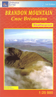
Brandon Mountain
Brandon Mountain on the Dingle Peninsula at 1:25, 000 from the Ordnance Survey of Ireland, printed on light, waterproof and tear-resistant plastic paper and presenting hiking routes on a very clear picture of the area’s topography.Cartography is an enlargement of the country’s topographic survey at 1:50, 000, with contour lines 10m intervals, less densely packed here, altitude colouring and numerous additional spot heights, plus graphics for different types of woodland. Place names, where appropriate, are shown in their English and Irish versions.The map highlights the course of the Dingle Way long-distance footpath, as well as local waymarked or unmarked hiking trails, including the Pilgrims Routes. Symbols indicate youth hostels, car parks, view points, etc. Irish
national grid lines are drawn at 1km intervals.
national grid lines are drawn at 1km intervals.

Product Description
Reviews/Comments
Add New
Vouchers
No voucher codes found.
Do you know a voucher code for this product or supplier? Add it to Insights for others to use.
Do you know a voucher code for this product or supplier? Add it to Insights for others to use.
 Denmark