
 United Kingdom
 France
 Germany
 Netherlands
 Sweden
 USA
USA
 Italy
Italy
 Spain
Spain
More From Contributor


Bradley Fold 1908
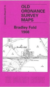
Bradley Fold in 1908 in a fascinating series of reproductions of old Ordnance Survey plans in the Alan Godfrey Editions, ideal for anyone interested in the history of their neighbourhood or family. Selected towns in Great Britain and Ireland are covered by maps showing the extent of urban development in the last decades of the 19th and early 20th century.In this title: the map covers the hamlet of Bradley Fold, midway between Bolton and Bury. This was a semi rural area and features include Bradley Fold with station, Bradley Fold Works, Bradley Fold Pottery, Bradley Fold Print Works, Ainsworth Mills, Ainsworth Vale Dye Works, Ainsworth Mercerising Works, Coggra Fold. Bradley Fold Junction is near the eastern margin. On the reverse is a large section of the 1927 revision of the map
showing much more industrial development, now including Fold Mill, Starmount Print Works, Lomax Bank Paper Mill, a much larger Bradley Fold Works, St Oswald's Mission church and other development along Bury New Road. About the Alan Godfrey Editions of the 25
showing much more industrial development, now including Fold Mill, Starmount Print Works, Lomax Bank Paper Mill, a much larger Bradley Fold Works, St Oswald's Mission church and other development along Bury New Road. About the Alan Godfrey Editions of the 25
Product Description
Reviews/Comments
Add New
Intelligent Comparison
Archived Product
Bradley Fold 1908 Stanfords
£3.50
Vouchers
No voucher codes found.
Do you know a voucher code for this product or supplier? Add it to Insights for others to use.
Do you know a voucher code for this product or supplier? Add it to Insights for others to use.
 Denmark