More From Contributor
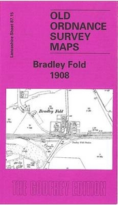
£9.99
Bradford in the Cassini Past & Present map series which covers town & cities of England & Wales & offers a unique way of tracing their history & expansion by showing four different periods of their development using Ordnance Survey mapping from the mid-19th century, the late 19th century, the 1920s & the present day. Coverage

Includes::
Baildon, Bingley, Guiseley, Horsforth, Menson, Pudsey, Queensbury, Shipley & Yeadon. Each Past & Present map consists of four panels, all centred on a city or a town & covering exactly the same 15km x 15km area. Three of the panels reproduce Ordnance Survey’s historical editions: the Old Series, the Revised New Series & the Popular Edition, enlarged from their original inch-to-the-mile to match the 1:50, 000 scale of the present-day Landranger extract shown in the fourth panel.* Old Series: the first detailed survey mapping dating from the first half of the 19th century, in black & white & with relief shown by hachuring.* Revised New Series from 1880s/1900s, with some colouring & a mixture of hachuring & contour lines.* Popular Edition from the inter-war years, with contour lines & colouring to indicate woodlands, parks, etc. National Grid lines are shown on all four panels for easy comparison across the four time periods. Historical notes, details of the original maps used & web-links for local history societies & other sources of information are also provided. *PLEASE NOTE:** Reproductions from the Ordnance Survey’s historical series are also available as maps of a wider area, with each title corresponding in its coverage to a present day Landranger map. Please see Great Britain: Cassini Historical Reproductions of Ordnance Survey One-Inch Maps series.* Stanfords can also print on request mapping from all the series *centring the map on a location of your choice.* For more information please click on the link below.

...
Archived Product
£4.95
Bradford Street Atlas at 1:15, 840 / 4 to a mile, in an indexed, glove box size paperback format, with national grid referencing. Street atlas covers Bradford, Brighouse, Halifax, Keighley, Baildon, Bingley, Cullingworth, Ell&, Greetl&, Haworth, Northowram, Queensbury, Shipley, Sowerby Bridge, Thorton & Wyke, with enlargements of Bradford city centre & Halifax town centre at a scale of 1;7, 920 / 8 ...
Archived Product
£3.50
Bradford Thornbury & Bradford Moor in 1906 in a fascinating series of reproductions of old Ordnance Survey plans in the Alan Godfrey Editions, ideal for anyone interested in the history of their neighbourhood or family. The map covers the Bradford Moor & Thornbury area east of Bradford, together with much of Undercliffe. Coverage stretches from Lonsdale Street eastward to Stone Stile Lane, & from Tower Street southward to Carrington Street. Features include Bradford Moor Barracks, tramways & Thornbury depot, Miryshay, Tewit Hall, Scarr Hall, Bradford Moor Park, Highfield House, Burlington Works, Thornbury Works, Grange Farm, fever hospital, stretch of GNR Shipley Branch, Gain Lane Farm, Gain Lane Quarry, Intake Road area, Quarry House, St Clement`s church, etc. On the reverse are extracts from a 1912 street directory, including Killinghall Road, Pollard Lane, Rushton Road, Thornbury Drive & Woodhall Road. About the Alan Godfrey Editions of the 25” OS Series: Selected towns in Great Britain & Ireland are covered by maps showing the extent of urban development in the last decades of the 19th & early 20th century. The plans have been taken from the Ordnance Survey mapping & reprinted at about 15 inches to one mile (1:4, 340). On the reverse most maps have historical notes & many also include extracts from contemporary directories. Most maps cover about one mile (1.6kms) north/south, one & a half miles (2.4kms) across; adjoining sheets can be combined to provide wider coverage.FOR MORE INFORMATION & A COMPLETE LIST OF ALL AVAILABLE TITLES PLEASE CLICK ON THE SERIES LINK. ...
Archived Product
£4.99
This is a new edition in the AA's ground-breaking series of street atlases, covering Bradford & Halifax in a handy glovebox size. The atlas uses the latest digital data for Britain from Ordnance Survey & the AA & also

Includes::
National Grid Referencing as used by the emergency services. All of the maps clearly show recommended restaurants, hotels, one-way streets & car parks, with 24-hour petrol stations now highlighted. Featuring a clever use of colour to ensure they can be read under street lighting, these maps are all you need to keep you on the move.

...
Archived Product
£2.95
Bradley Fold in 1908 in a fascinating series of reproductions of old Ordnance Survey plans in the Alan Godfrey Editions, ideal for anyone interested in the history of their neighbourhood or family. Selected towns in Great Britain & Ireland are covered by maps showing the extent of urban development in the last decades of the 19th & early 20th century. In this title: the map covers the hamlet of Bradley Fold, midway between Bolton & Bury. This was a semi rural area & features include Bradley Fold with station, Bradley Fold Works, Bradley Fold Pottery, Bradley Fold Print Works, Ainsworth Mills, Ainsworth Vale Dye Works, Ainsworth Mercerising Works, Coggra Fold. Bradley Fold Junction is near the eastern margin. On the reverse is a large section of the 1927 revision of the map showing much more industrial development, now including Fold Mill, Starmount Print Works, Lomax Bank Paper Mill, a much larger Bradley Fold Works, St Oswald's Mission church & other development along Bury New Road. About the Alan Godfrey Editions of the 25 ...
Archived Product
£20.00
For 60 minutes this summer, the British public stopped what they were doing switched on their radios, their TVs, refreshed their Twitter feeds & followed Bradley Wiggins`s attempt to break one of sport`s most gruelling records: The Hour. The premise is simple enough: how far can you cycle in one hour. But it is thought to be one of the toughest events an athlete can endure, both physically & psychologically. Eddy Merckx, cycling`s uber-champ, called it the hardest thing he ever did. Wiggins, like many before him, discovered the unique pain of pushing yourself as hard as you can for 60 minutes. In this revealing book, Bradley Wiggins takes you behind the scenes of his record attempt. From planning to preparation, to training to execution, Bradley shares his thoughts on his sacrifices, his heroes, & the people who have supported him along the way as well as what`s to come as he heads towards the twilight of his stellar career. Supported by stunning photography, My Hour is a fitting celebration of one of Britain`s best-loved sportsmen in his finest hour. ...
Archived Product
£8.99
On 22 July 2012 Bradley Wiggins made history as the first British cyclist to win the Tour de France. Ten days later at the London Olympic Games he won the time trial to become his country`s most decorated Olympian. In an instant ` Wiggo`, the kid from Kilburn, was a national hero. Two years previously, however, Wiggins had been staring into the abyss. His much-hyped attempt to conquer the 2010 Tour de France had ended in public humiliation. Poor results & indifferent form left him facing the sack from Team Sky. & then he was hit with the tragic news of the death of his granddad, George, the man who had raised him as a young boy. At rock bottom, Wiggins had to reach deep inside himself & find the strength to fight his way back. Outspoken, honest, intelligent & fearless, Wiggins has been hailed as the people`s champion. In My Time he tells the story of the remarkable journey that led him from his lowest ebb to win the world`s toughest race. In his own words he reveals the personal anguish that has driven him on & what it`s like behind the scenes at Team Sky: the brutal training regimes, the sacrifices & his views on his teammates & rivals. He talks too about his anger at the spectre of doping that pursues his sport, how he dealt with the rush of taking Olympic gold & above all what it takes to be the greatest. ...
Archived Product
£7.99
Rising from an inner city background, abandoned by his pro cyclist father as a toddler, Bradley Wiggins became a prodigious talent. World Junior Champion, World Champion & Olympic Champion were all titles that came his way at a startlingly young age, but what he really wanted was success on the road. ` Wiggo`s` reinvention on the path to becoming Britain`s first Tour de France winner in over a hundred years of racing is one of sport`s most uplifting & inspiring stories. In this captivating & insightful narrative, Wiggins` old friend & colleague John Deering sets this remarkable story against the backdrop of Wiggins` crushing Tour victory, his races along the thousands of kilometres of French tarmac, telling the tale of his brutal procession from Liege to Paris in counterpoint to his fascinating life. From a Kilburn council estate to the Champs Elysees via the Olympics, Paul Weller & the world`s most glorious sideburns, the legend of Bradley Wiggins is unravelled like never before. ...
Archived Product
£3.50
Bradley, Coseley & Wednesbury Oak in 1901 in a fascinating series of reproductions of old Ordnance Survey plans in the Alan Godfrey Editions, ideal for anyone interested in the history of their neighbourhood or family. Two versions have been published for this area. Most of Bradley is covered, extending southward to Wednesbury Oak & Coseley. Areas shown include Hall Green, Batmans Hill, Bradley Colliery, Lower Bradley, Hall Fields, Daisy Bank & Wednesbury Oak Colliery. Features on the 1901 version include the GWR OWW railway with Daisy Bank station, a short stretch of the LNWR Stour Valley line with Deepfields & Coseley station, Highfields Hall, Highfields Colliery (disused), Capponfield Colliery (disused), Hopyard Colliery (disused), old coal shafts, Birmingham Canal (Wolverhampton Level), Bradley Locks, Schoolfield Colliery (disused), Bradley Pumping Engine, Batmanshill Houses, many signs of old industry or mine workings, tramway, industrial sidings & tramways, Hardingsfield Colliery, Coseley Hall, Fullwoods End Colliery, Daisy Bank House, Christ Church, etc. The 1913 version covers the same area; changes include a new site for Deepfields & Coseley station. A directory of Bradley on the reverse of the 1901 version, & a commercial directory of Coseley on the 1913 map. About the Alan Godfrey Editions of the 25” OS Series: Selected towns in Great Britain & Ireland are covered by maps showing the extent of urban development in the last decades of the 19th & early 20th century. The plans have been taken from the Ordnance Survey mapping & reprinted at about 15 inches to one mile (1:4, 340). On the reverse most maps have historical notes & many also include extracts from contemporary directories. Most maps cover about one mile (1.6kms) north/south, one & a half miles (2.4kms) across; adjoining sheets can be combined to provide wider coverage.FOR MORE INFORMATION & A COMPLETE LIST OF ALL AVAILABLE TITLES PLEASE CLICK ON THE SERIES LINK. ...
Archived Product
£2.95
Bradley, Coseley & Wednesbury Oak in 1913 in a fascinating series of reproductions of old Ordnance Survey plans in the Alan Godfrey Editions, ideal for anyone interested in the history of their neighbourhood or family. Selected towns in Great Britain & Ireland are covered by maps showing the extent of urban development in the last decades of the 19th & early 20th century. In this title: two versions have been published for this area. Most of Bradley is covered, extending southward to Wednesbury Oak & Coseley. Areas shown include Hall Green, Batmans Hill, Bradley Colliery, Lower Bradley, Hall Fields, Daisy Bank & Wednesbury Oak Colliery. Features on the 1901 version include the GWR OWW railway with Daisy Bank station, a short stretch of the LNWR Stour Valley line with Deepfields & Coseley station, Highfields Hall, Highfields Colliery (disused), Capponfield Colliery (disused), Hopyard Colliery (disused), old coal shafts, Birmingham Canal (Wolverhampton Level), Bradley Locks, Schoolfield Colliery (disused), Bradley Pumping Engine, Batmanshill Houses, many signs of old industry or mine workings, tramway, industrial sidings & tramways, Hardingsfield Colliery, Coseley Hall, Fullwoods End Colliery, Daisy Bank House, Christ Church etc. The 1913 version covers the same area; changes include a new site for Deepfields & Coseley station. A directory of Bradley on the reverse of the 1901 version, & a commercial directory of Coseley on the 1913 map. About the Alan Godfrey Editions of the 25 ...
Archived Product

Bradley Fold 1908

Bradley Fold in 1908 in a fascinating series of reproductions of old Ordnance Survey plans in the Alan Godfrey Editions, ideal for anyone interested in the history of their neighbourhood or family. The map covers the hamlet of Bradley Fold, midway between Bolton and Bury. This was a semi rural area and features include Bradley Fold with station, Bradley Fold Works, Bradley Fold Pottery, Bradley Fold Print Works, Ainsworth Mills, Ainsworth Vale Dye Works, Ainsworth Mercerising Works, Coggra Fold, etc. Bradley Fold Junction is near the eastern margin. On the reverse is a large section of the 1927 revision of the map showing much more industrial development, now including Fold Mill, Starmount Print Works, Lomax Bank Paper Mill, a much larger Bradley Fold Works, St Oswald`s
Mission church and other development along Bury New Road. About the Alan Godfrey Editions of the 25” OS Series:Selected towns in Great Britain and Ireland are covered by maps showing the extent of urban development in the last decades of the 19th and early 20th century. The plans have been taken from the Ordnance Survey mapping and reprinted at about 15 inches to one mile (1:4, 340). On the reverse most maps have historical notes and many also include extracts from contemporary directories. Most maps cover about one mile (1.6kms) north/south, one and a half miles (2.4kms) across; adjoining sheets can be combined to provide wider coverage.FOR MORE INFORMATION AND A COMPLETE LIST OF ALL AVAILABLE TITLES PLEASE CLICK ON THE SERIES LINK.
RIP - This product is no longer available on our network. It was last seen on 25.09.2019

This page now acts as a permanent archive for this product. Add more information using the comments box below to ensure it can still be found by future generations.

Use our search facility to see if it is available from an alternative contributor.
  • External links may include paid for promotion
  • Availability: Out Of Stock
  • Supplier: Stanfords
  • SKU: 9781841513645
Availability: In Stock
£3.50

Product Description

Bradley Fold in 1908 in a fascinating series of reproductions of old Ordnance Survey plans in the Alan Godfrey Editions, ideal for anyone interested in the history of their neighbourhood or family. The map covers the hamlet of Bradley Fold, midway between Bolton & Bury. This was a semi rural area & features include Bradley Fold with station, Bradley Fold Works, Bradley Fold Pottery, Bradley Fold Print Works, Ainsworth Mills, Ainsworth Vale Dye Works, Ainsworth Mercerising Works, Coggra Fold, etc. Bradley Fold Junction is near the eastern margin. On the reverse is a large section of the 1927 revision of the map showing much more industrial development, now including Fold Mill, Starmount Print Works, Lomax Bank Paper Mill, a much larger Bradley Fold Works, St Oswald`s Mission church & other development along Bury New Road. About the Alan Godfrey Editions of the 25” OS Series: Selected towns in Great Britain & Ireland are covered by maps showing the extent of urban development in the last decades of the 19th & early 20th century. The plans have been taken from the Ordnance Survey mapping & reprinted at about 15 inches to one mile (1:4, 340). On the reverse most maps have historical notes & many also include extracts from contemporary directories. Most maps cover about one mile (1.6kms) north/south, one & a half miles (2.4kms) across; adjoining sheets can be combined to provide wider coverage.FOR MORE INFORMATION & A COMPLETE LIST OF ALL AVAILABLE TITLES PLEASE CLICK ON THE SERIES LINK.

Reviews/Comments

Add New

Intelligent Comparison

Oooops!
We couldn't find anything!
Perhaps this product's unique.... Or perhaps we are still looking for comparisons!
Click to bump this page and we'll hurry up.

Price History

Vouchers

No voucher codes found.
Do you know a voucher code for this product or supplier? Add it to Insights for others to use.

Facebook

Jargon Buster

Contemporary - Modern era design
Paper - A thin sheet mainly used for writing. Available in a variety of colours. Made mainly from wood pulp.
Contemporary - A design reference to indicate post war modern design
History - Anything that happens in the past. An acedemic subject.
Large - something that takes up more space than normal.
Road - a manmade lane or a path that is used to speed up travel.
Contemporary - An object that is living in the same time.
Mill - A building which can grind grain into flour.
Junction - A point where two or more things come together, typically used to describe roads
Ideal - Something that satisfies a perfect criteria.
Print - A mechanical process of putting text onto paper. It can also relate to a pattern on an item.
Family - A group of people that live together made up from parents and children.

Supplier Information

Stanfords
Stanfords was established in 1853 and opened their iconic Covent Garden flagship store in 1901. They have become the top retailer of maps, travel books and accessories in the UK and arguably offer the largest selection of maps and travel books worldwide. Famous names such as Captain Robert Falcon Scott, Ranulph Fiennes and Michael Palin have purchased from Stanfords. They now have a shop in Bristol and both stores together with other venues operate a calendar of events including talks, book signings and exhibitions. As a specialist map retailer, the map selection is comprehensive and includes road maps, street maps and walking maps from worldwide destinations, as well as a selection of world atlases and wall maps. Books include travel guides and travel literature. Stanfords also stock globes, from miniatures made of blue marble to magnificent floor-standing globes. The website features a selection of interesting articles on travel topics.
Page Updated: 2023-11-12 20:15:36

Community Generated Product Tags

Oh No! The productWIKI community hasn't generated any tags for this product yet!
Menu