More From Contributor
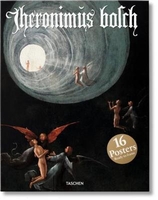
£26.50
Borrowdale is probably the most beautiful valley in the Lake District & offers the rock climber a huge variety of climbing styles often in stunning panoramic settings. The valley is well-known for accessible roadside climbing on crags such as Reecastle, the ever popular Shepherd`s Crag, Quayfoot Buttress & the Bowderstone area, with most crags enjoying sun in the afternoon. There are also a number of classic mountain venues like Gillercomb & Raven Crag, Combe Gill where solitude & far reaching vistas over the Lakeland fells can be savoured. This 2016 Borrowdale guide from the FRCC is fully revised. The valley is divided into six logical areas presented with specially commissioned showcase action images & clear OS based mapping. The popular A5 format provides greater clarity & there is full photodiagram coverage. The less well-trodden places such as the Seathwaite buttresses, Combe Gill & Langstrath are given clear photoplan coverage which clarifies these complex areas of small immaculate outcrops. Exciting action images & the usual supplementary essential information such as parking & camping are included together with a comprehensive crag selector. The Fell & Rock Climbing Club is the premier rock climbing & mountaineering club in the English Lake District. The Club was founded in 1906-07 & has been publishing a definitive series of climbing guidebooks to the Lakes since 1922. ...
Archived Product
£14.99
This book is a celebration of the food & passion behind this Melbourne institution. The book is split into three chapters: Tears, which is the story of how the restaurant came about; Vodka, which is a definitive guide to Polish vodkas, vodka tasting notes & how to match food with vodka, as well as recipes for the restaurant's most popular cocktails; & Borsch, which features warming Polish classics, such as cabbage rolls, blintzes, beetroot soup & borsch, as well as modern dishes, desserts & sharing plates. Edgy photography by Mark Roper, a comprehensive guide to vodka, & delicious, popular recipes make Borsch, Vodka & Tears an instant classic for fans beyond the restaurant itself. ...
Archived Product
£11.50
Topographic survey of France at 1:25, 000 in IGN`s excellent TOP25 / Série Bleue series. All the maps are GPS compatible, with a 1km UTM grid plus latitude & longitude lines at 5’ intervals. Contours are at 5m intervals except for mountainous areas where the maps have contours at 10m intervals, vividly enhanced by hill shading & graphics for rocky terrain. Colouring with graphics indicates different types of vegetation or land use (deciduous or coniferous forests, moors, orchards, vineyards, etc). PLEASE NOTE: coverage of France at this scale is currently being revised – the format & the presentation of each title are indicated by the letters at the end of its Sheet Reference number (e.g. 0416ET, 3531ETR, 1923SB, etc.)MAPS WITH FULL TOURIST OVERPRINT & AN ENGLISH MAP LEGEND: all TOP25 maps & the SB editions of Série Bleue have an overprint highlighting waymarked walking trails including long-distance GR routes &, where appropriate, ski routes. Symbols indicate campsites, gîtes d’etape, refuges, equestrian centres & other recreational facilities or sites, tourist information centres, cultural heritage, etc. Towns & locations of particular interest are highlighted.- ET or OT = single-sided TOP25 map covering approx. 29x 21 km / 18x 13 miles.- ETR or OTR = waterproof & tear resistant TOP25 map covering the same area as the corresponding ET or OT number, but double-sided, printed on a smaller size sheet with a good overlap between the sides.- SB = Série Bleue map with full tourist overprint; these maps, first introduced in summer 2014, each cover approx. 29x 24km / 18x 15 miles.SÉRIE BLEUE maps with numbers ending in E (Est) or O (Ouest): most editions now indicate the GR routes, but do not show any other tourist information. Map legend is in French only. Each map covers approx. 14x 20km / 9x 12 miles. ...
Archived Product
£6.99
Borzsonyin a series of contoured hiking & recreational maps from the Budapest based Cartographia, with hiking routes & other tourist information, including in many titles street plans, cycling trails, etc. The maps have contours at 10m intervals with relief shading & spot heights, plus colouring and/or graphics to indicate different types of vegetation. An overprint highlights local hiking paths, with cycling routes also included in some titles. Symbols mark various places of interest, sport & recreational facilities, including campsites & other tourist accommodation, locations of petrol stations, etc. The maps show 1km lines of the country’s national grid. Map legends are in Hungarian & German only. On the reverse many titles include street plans of holiday centres & further information on the area, in Hungarian only. ...
Archived Product
£3.50
Boscastle in 1905 in a fascinating series of reproductions of old Ordnance Survey plans in the Alan Godfrey Editions, ideal for anyone interested in the history of their neighbourhood or family. The map covers much of the village of Boscastle, where the River Valency runs into the sea, stretching from Penally Point eastward to Minster Wood, & from the northern tip of High Street northward to Pentargon. Features include Penally House, Napoleon Inn, Bottreaux Castle, Boscastle Harbour, Fore Street, Dunn Street, New Road, Ship Inn, Forrabury Comnmon, St Symphorian`s church Forrabury & Western Blackapit. On the reverse is a 1910 directory. About the Alan Godfrey Editions of the 25” OS Series Selected towns in Great Britain & Ireland are covered by maps showing the extent of urban development in the last decades of the 19th & early 20th century. The plans have been taken from the Ordnance Survey mapping & reprinted at about 15 inches to one mile (1:4, 340). On the reverse most maps have historical notes & many also include extracts from contemporary directories. Most maps cover about one mile (1.6kms) north/south, one & a half miles (2.4kms) across; adjoining sheets can be combined to provide wider coverage.FOR MORE INFORMATION & A COMPLETE LIST OF ALL AVAILABLE TITLES PLEASE CLICK ON THE SERIES LINK. ...
Archived Product
£12.99
Map No. 1291, Bosco/ Gurin, in the topographic survey of Switzerland at 1:25, 000 from Bundesamt für Landestopographie (swisstopo), covering the whole country on 247 small format sheets, with special larger maps published for popular regions including some titles now available in hiking versions. Highly regarded for their superb use of graphic relief & hill shading, the maps give an almost 3-D picture of Switzerland`s mountainous terrain. Contours are at 10 m intervals, with 20m intervals in the mountainous areas. All the maps have a 1-km grid for Swiss national coordinates (datum CH 1903). * Small format sheets (Nos. 1011
- 1374)* Map legend in the language of the area covered by the map. Additional margin ticks show latitude & longitude in steps of 2`. The area covered by each map is 17 x 12 km (11 x 7 miles approx). * Special larger sheets (Nos. from 2501 onwards) – STANDARD editions:* No map legend is included but a separate leaflet can be provided instead. The area covered by each map is 25 x 17 km (15 x 11 miles approx).* Special larger sheets (Nos. from 2501 onwards) – HIKING editions:* An overprint highlights hiking, mountain & alpine paths, including regional & national long-distance trails. The maps also show bus routes with bus stops, plus inns in remote locations. The area covered by each map is 25 x 17 km (15 x 11 miles approx).
...
Archived Product
£3.50
Boscombe & Pokesdown in 1923 in a fascinating series of reproductions of old Ordnance Survey plans in the Alan Godfrey Editions, ideal for anyone interested in the history of their neighbourhood or family. In 1851 Bournemouth had a population of just 695 but over the next few decades it rose to become one of England`s greatest seaside resorts & by 1911 with a population of 78, 764 it was second only to Brighton. The town is covered by three maps, taken from the original Ordnance Survey Hampshire series. The North Bournemouth map covers the northern part of the town, stretching from Braidley Road eastward to Knole Road & St Clements church, & from Iddesleigh Road & the cemetery southward to Christchurch Road & Old Christchurch Road. The Central station is near the centre of the map. Features include Dean Park, St Augustin`s church, Wimborne Road, Richmond Gardens, Town Hall, Madeira Vale, Hotel Metropole, Municipal College, Lansdowne Road, Holdenhurst Road, engine shed & turntable, St Paul`s church, tramways & tram depot, Knyveton Gardens, & innumerable villas. This Boscombe & Pokesdown map continues coverage west through Boscombe, Pokesdown & Freemantle. The Christchurch Road runs through the centre of the map & coverage extends from Drummond Road eastward to Beaufort Road & Grand Avenue. Features include Boscombe & Pokesdown stations, Kings Park, cemetery, St John`s church, Palmerston Road, Boscombe Chine Gardens, Hotel Burlington, Groveley Manor, Wentworth Lodge, Seabourne Road, tramways & depot, Convent & isolation hospital. A list of private residents for Boscombe is on the reverse. The Central Bournemouth map shows a three miles stretch of the coastline from the Winter Gardens eastward to Fisherman`s Walk. Features include Bournemouth Pier, Pleasure Grounds, Winter Gardens, St Peter`s church, Royal Bath Hotel, Royal Exeter Hotel, St Swithun`s church, East Cliff, Russell Cotes Museum, Westover Palace, Boscombe Pier, Boscombe Spa, Portman Ravine, etc. About the Alan Godfrey Editions of the 25” OS Series Selected towns in Great Britain & Ireland are covered by maps showing the extent of urban development in the last decades of the 19th & early 20th century. The plans have been taken from the Ordnance Survey mapping & reprinted at about 15 inches to one mile (1:4, 340). On the reverse most maps have historical notes & many also include extracts from contemporary directories. Most maps cover about one mile (1.6kms) north/south, one & a half miles (2.4kms) across; adjoining sheets can be combined to provide wider coverage.FOR MORE INFORMATION & A COMPLETE LIST OF ALL AVAILABLE TITLES PLEASE CLICK ON THE SERIES LINK. ...
Archived Product
£9.99
Bosnia-Herzegovina & Montenegro presented at 1:400, 000 on a double-sided road map from ITMB. The map divides the region north/south, with a very generous overlap & Sarajevo included on both sides. Coverage

Includes::
the whole of Kosovo. Names of larger towns in Montenegro, Kosovo & in the adjoining regions of Serbia are also shown in the Cyrillic alphabet. In contrast to most ITMB road map, this title has a single-colour base without any altitude colouring to show the topography, but

Includes::
spot heights & plenty of names of mountain ranges, etc. National parks & protected areas are highlighted. Road network shows driving distance on main & selected small roads. Railway lines are included & local airports are marked. Symbols highlight various places of interest. The map has latitude & longitude lines at 20’ intervals. Each side has a separate index.


...
Archived Product
£6.95
Bosnia & Herzegovina in the Culture Smart range of pocket-sized guide books; providing detailed information on local customs, culture, etiquette & manners & ensuring that visitors are prepared for a diverse range of social environments. The series covers an extensive number of countries worldwide & are designed both for those working & living abroad, as well as for visitors who do not want to offend, either intentionally or inadvertently. Their aim is to prevent readers from making embarrassing mistakes & feel confident in unfamiliar situations, while preparing them before arrival on what to expect & how to behave. Each guide is arranged thematically, with dedicated individual chapters on land & people, values & attitudes, customs & traditions, making friends, people at home, ‘time-out’, travelling & communicating. There is also a separate chapter for business travelers, with important information on subjects such as business culture, meetings & making appointments. A Further Reading section also offers a list of recommended other history, travel literature & language titles available on the country. ...
Archived Product
£15.99
From an expert author who has lived & worked in the region for over two decades, Bradt`s Bosnia & Herzegovina is the most comprehensive English-language guidebook available to the mountainous heart of the Western Balkans. It covers the country`s diverse Mediterranean landscapes, from the southern Herzegovina cities of Mostar & Trebinje to the lush & green Alpine regions of Sarajevo & Banja Luka, plus second-to-none coverage of the capital city Sarajevo. Now in its fifth edition, not only does the guide feature smaller towns & villages off the beaten track, with more detail on the history, culture & sights, & more opinionated & entertaining reviews of hotels & restaurants. For this new updated edition, the Sarajevo chapter has been fully overhauled with brand new mapping, & a complete run-down of all of the Herzegovina wineries has been included. There is also new coverage on the Via Dinarica regional mega trail that carves its way through the heart of Bosnia & Herzegovina`s Dinaric Alps & is chock full of activities & adventure for families & pros alike. All the regional maps have been completely overhauled. Also included are details of rural accommodation & farm stays within reach of some of the major hubs, plus an expanded chapter on Mostar & Trebinje. Two decades after the conflict that ravaged the region, Bosnia & Herzegovina has emerged as a unique, dynamic tourism destination. Whether you go in search of bears in the primeval Sutjeska National Park, wander the winding streets of Sarajevo`s Turkish quarter or put your feet up in Mostar with a glass of chilled ilavka, you are guaranteed to be charmed by the country`s rich natural & cultural heritage. ...
Archived Product

Bosch Poster Set

Hieronymus at home16 ready-to-frame prints from the rebel genius Hieronymus BoschBring a fantastical vision to your wall with these 16 ready-to-frame prints from the Renaissance rebel genius, Hieronymus Bosch, including spectacular details from The Garden of Earthly Delights.
RIP - This product is no longer available on our network. It was last seen on 25.09.2019

This page now acts as a permanent archive for this product. Add more information using the comments box below to ensure it can still be found by future generations.

Use our search facility to see if it is available from an alternative contributor.
  • External links may include paid for promotion
  • Availability: Out Of Stock
  • Supplier: Stanfords
  • SKU: 9783836542975
Availability: In Stock
£14.99

Product Description

Hieronymus at home 16 ready-to-frame prints from the rebel genius Hieronymus Bosch Bring a fantastical vision to your wall with these 16 ready-to-frame prints from the Renaissance rebel genius, Hieronymus Bosch, including spectacular details from The Garden of Earthly Delights.

Reviews/Comments

Add New

Intelligent Comparison

Oooops!
We couldn't find anything!
Perhaps this product's unique.... Or perhaps we are still looking for comparisons!
Click to bump this page and we'll hurry up.

Price History

Vouchers

No voucher codes found.
Do you know a voucher code for this product or supplier? Add it to Insights for others to use.

Facebook

Jargon Buster

Garden - An outside area with grass and foliage
garden - A planned space used for the display, cultivation and enjoyment of plants and other forms of nature.
Wall - A physical barrier between two areas
Set - a group of items usually related to one another. Some objects cannot function without the complete set of items.
Spectacular - Something that catches that eye due to its eye catchingness.
Poster - A printed picture used for decoration or information.
Poster - A large picture usually used for decoration.
Vision - To be able to imagine, also can mean what you can see.

Supplier Information

Stanfords
Stanfords was established in 1853 and opened their iconic Covent Garden flagship store in 1901. They have become the top retailer of maps, travel books and accessories in the UK and arguably offer the largest selection of maps and travel books worldwide. Famous names such as Captain Robert Falcon Scott, Ranulph Fiennes and Michael Palin have purchased from Stanfords. They now have a shop in Bristol and both stores together with other venues operate a calendar of events including talks, book signings and exhibitions. As a specialist map retailer, the map selection is comprehensive and includes road maps, street maps and walking maps from worldwide destinations, as well as a selection of world atlases and wall maps. Books include travel guides and travel literature. Stanfords also stock globes, from miniatures made of blue marble to magnificent floor-standing globes. The website features a selection of interesting articles on travel topics.
Page Updated: 2023-11-12 20:15:36

Community Generated Product Tags

Oh No! The productWIKI community hasn't generated any tags for this product yet!
Menu