More From Contributor
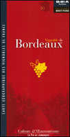
£20.50
Bordeaux à pied, FFRP topo-guide Ref. No. VI09, with 16 walks in the city centre & in the outer districts. Each walk is presented on a separate colour extract from a street plan or a detailed IGN map, with its description cross-referenced to the map. Current edition of this title was published in April 2016.ABOUT THE FFRP (Fédération française de la randonée pédestre) TOPOGUIDES: published in a handy A5 paperback format, the guides are the best companions for hiking in France. In addition to their topo-guides to the long-distance GR routes FFRP also publish an extensive range of guides with local day walks. Each walk in presented on a colour extract from IGN`s 1:50, 000 or 1:25, 000 topographic survey mapping overprinted with the route, with important points cross-referenced to the accompanying text, in French only, placed on the adjoining page. For each walk the guides also indicate the degree of difficulty & provide information on length, time & change in altitude, waymarking signs, access by road & parking facilities. An “info practiques” section of the guide indicates where shops, restaurants & accommodation can be found. The guides are published on high quality paper & include descriptions of the most interesting aspects of the surrounding region: historical & cultural sites, local specialties, fauna & flora, etc, all illustrated with colour photos. ...
Archived Product
£6.99
This is the savvy city breakers' pocket guide to seeing & doing more in Bordeaux
- with a fun-seeking & cost-conscious slant. It
...
Archived Product
£24.99
The Bordeaux wine growing region of France on a map showing its famous vineyards along the confluence of the Garonne & the Dordogne, with additional lists of the Appellations & different classifications for Médoc, Saint-Emilion, Graves, etc. The map is surrounded by a frame of the region’s famous labels from the Ch. Lafite, Latour & Margaux to less illustrious names. The map is available in four versions which may differ slightly in the shades of colouring but contain the same information:FOLDED MAP: available either from Edition Benoit or from the IGN.WALL MAP: available either on paper from Editions Benoit (this title) or encapsulated from the IGN. ...
Archived Product
£9.50
The Bordeaux wine growing region of France on a map showing its famous vineyards along the confluence of the Garonne & the Dordogne, with additional lists of the Appellations & different classifications for Médoc, Saint-Emilion, Graves, etc. The map is surrounded by a frame of the region’s famous labels from the Ch. Lafite, Latour & Margaux to less illustrious names. The map is available in four versions which may differ slightly in the shades of colouring but contain the same information:FOLDED MAP: available either from Edition Benoit or from the IGN (this title).WALL MAP: available either on paper from Editions Benoit or encapsulated from the IGN. ...
Archived Product
£11.95
A colourful folded map of the vineyards around the confluence of the Garonne & the Dordogne rivers. Colours distinguish the various appellations, & four insets concentrate on selected regions, presenting more detailed maps & diagrams explaining particular factors in the viticulture, eg. soil diversity & climatic effects. Indexed for towns. Symbols denote notable cellar, museums, wine shops, architectural highlights. Such locations are listed in the map cover, with brief descriptions & contact details. There is also a lexicon of wine-making terms & a diagram describing the red-wine making process. ...
Archived Product
£17.99
Topographic survey of Portugal at 1:50, 000 from the Instituto Geográfico do Exército, the country’s military survey organisation. The maps have contours at 20m intervals & in addition to the standard features shown on topographic mapping at this scale also indicate various types of terrain or vegetation (s&, terraces, rocks, woodlands, vineyards, etc). Each sheet covers an area of 32 x 20km (20 x 12.5 miles approx). The maps have a 1-km UTM grid plus latitude & longitude coordinates for the map corners. Map legend & a glossary of terms used on the maps include English.EDITION DATES: most titles in this series date from 1990s or later. To see all the titles in this series please click on the series link. ...
Archived Product
£17.99
Topographic survey of Portugal at 1:100, 000 from the Instituto Geográfico Português, the country’s civilian survey organisation. The maps have contours at 50m intervals & in addition to the standard features shown on topographic mapping at this scale also indicate various types of vegetation (vineyards, olive groves, etc). Each sheet covers an area of 64 x 40km (40 x 25 miles approx). The maps have latitude & longitude margin ticks at 1’ intervals, plus show UTM coordinates for the map corners. Map legend is in Portuguese only.PLEASE NOTE
- EDITION DATES: some sheets at this scale date back to the 1950s or 1960s. For more recent editions please see IGP’s 1:25, 000 series where each 50K map is divided into four quarters. To see all the titles in the 1:100, 000 series please click on the series link.
...
Archived Product
£17.99
Topographic survey of Portugal at 1:50, 000 from the Instituto Geográfico Português, the country’s civilian survey organisation. The maps have contours at 25m intervals & in addition to the standard features shown on topographic mapping at this scale also indicate various types of vegetation (vineyards, olive groves, etc). Each sheet covers an area of 32 x 20km (20 x 12.5miles approx). The maps have latitude & longitude margin ticks at 1’ intervals & UTM coordinates for the map corners – each sheet also shows conversion details from BBLx (Bessel-Bonnie system, Datum Lisbon) to UTM. Map legend is in Portuguese only.EDITION DATES: most titles in this series have now been updated in the 1990s or later. To see all the titles in this series please click on the series link. ...
Archived Product
£10.00
Want to find out how British you really are? From our stiff upper lips & blithe willingness to form an orderly queue, to our quirky traditions, drunken antics & borderline psychotic leisure pursuits, Brits are renowned throughout the world for being so... darned... British. We`re a mass of contradictions, as changeable as the weather in the Scottish highlands, as cosy as a Cornish cream tea, as bright & colourful as a chicken tikka masala, or as morose as a lump of Welsh slate. This unique quiz book probes, exposes & celebrates the true essence of Britishness in all its guises, from chasing cheese downhill & self-deprecation, to naming cakes after Northern towns & always remaining alert for a fruity innuendo. ...
Archived Product
£12.95
Experienced walker Alan Hall’s Cicerone guide to The Border Country
- A Walker’s guide, provides a detailed exploration of the
...
Archived Product

Bordeaux Wine Map

The Bordeaux wine growing region of France on a map showing its famous vineyards along the confluence of the Garonne and the Dordogne, with additional lists of the Appellations and different classifications for Médoc, Saint-Emilion, Graves, etc. The map is surrounded by a frame of the region’s famous labels from the Ch. Lafite, Latour and Margaux to less illustrious names. The map is available in four versions which may differ slightly in the shades of colouring but contain the same information:FOLDED MAP: available either from Edition Benoit (this title) or from the IGN.WALL MAP: available either on paper from Editions Benoit or encapsulated from the IGN.
RIP - This product is no longer available on our network. It was last seen on 25.09.2019

This page now acts as a permanent archive for this product. Add more information using the comments box below to ensure it can still be found by future generations.

Use our search facility to see if it is available from an alternative contributor.
  • External links may include paid for promotion
  • Availability: Out Of Stock
  • Supplier: Stanfords
  • SKU: 9782843541605
Availability: In Stock
£7.50

Product Description

The Bordeaux wine growing region of France on a map showing its famous vineyards along the confluence of the Garonne & the Dordogne, with additional lists of the Appellations & different classifications for Médoc, Saint-Emilion, Graves, etc. The map is surrounded by a frame of the region’s famous labels from the Ch. Lafite, Latour & Margaux to less illustrious names. The map is available in four versions which may differ slightly in the shades of colouring but contain the same information:FOLDED MAP: available either from Edition Benoit (this title) or from the IGN.WALL MAP: available either on paper from Editions Benoit or encapsulated from the IGN.

Reviews/Comments

Add New

Intelligent Comparison

Oooops!
We couldn't find anything!
Perhaps this product's unique.... Or perhaps we are still looking for comparisons!
Click to bump this page and we'll hurry up.

Price History

Vouchers

No voucher codes found.
Do you know a voucher code for this product or supplier? Add it to Insights for others to use.

Facebook

Jargon Buster

Paper - A thin sheet mainly used for writing. Available in a variety of colours. Made mainly from wood pulp.
Wine - An alcoholic drink made from fermented grapes.
France - A state situated in Western Europe with several overseas territories.
Wall - A physical barrier between two areas

Supplier Information

Stanfords
Stanfords was established in 1853 and opened their iconic Covent Garden flagship store in 1901. They have become the top retailer of maps, travel books and accessories in the UK and arguably offer the largest selection of maps and travel books worldwide. Famous names such as Captain Robert Falcon Scott, Ranulph Fiennes and Michael Palin have purchased from Stanfords. They now have a shop in Bristol and both stores together with other venues operate a calendar of events including talks, book signings and exhibitions. As a specialist map retailer, the map selection is comprehensive and includes road maps, street maps and walking maps from worldwide destinations, as well as a selection of world atlases and wall maps. Books include travel guides and travel literature. Stanfords also stock globes, from miniatures made of blue marble to magnificent floor-standing globes. The website features a selection of interesting articles on travel topics.
Page Updated: 2023-11-12 20:15:36

Community Generated Product Tags

Oh No! The productWIKI community hasn't generated any tags for this product yet!
Menu