More From Contributor
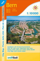
£9.99
Double-sided detailed map dividing Bermuda east/west. Each half has two separate indexes: one for streets & roads & another for important places & points of interest, plus a street plan of its respective main town: St. George’s & Hamilton. Relief of the island is shown by elevation colouring. The map shows parks, numerous golf courses, beaches, coral reefs, caves, places of interest, etc. No geographical coordinates are provided. The two street plans indicate one way streets & main places of interest in each town. ...
Archived Product
£13.99
Bermuda native Rosemary Jones provides her firsthand insight into the best this balmy island has to offer, from shopping for duty-free treasures in the capital of Hamilton to exploring St. George`s, home of the island`s first settlers. Jones also offers creative travel ideas, such as Vacation with the Kids, On the Wild Side, & A Romantic Retreat. With expert advice on lounging on pink-sand beaches, golfing at the famous Mid Ocean Club, & scuba-diving on shipwrecks, Moon Bermuda gives travelers the tools they need to create a more personal & memorable experience. This full-colour guide

Includes::
vibrant photos & helpful maps.

...
Archived Product
£19.95
Attractive 93x 71cm topographical wallmap of the isl&, with street maps of Hamilton & St George included. On the main map general relief is shown by hill-shading, spot heights & contours at 50ft intervals. The principal road network is marked & some road names are shown. Marsh areas, beaches, golf courses & built-up areas are shown & scattered buildings are marked. In particular, selected buildings are identified eg. schools, churches, major hotels. Ferry routes across Great Sound are marked, lighthouses are marked & many islands, beaches & bays are named. Latitude & longitude values are shown at the sheet corners only, & there are no grid lines. Parish, municipal & USAF boundaries are indicated. Street plans of Hamilton & St George at 1:7040 are included in insets. These show street names & identify many notable buildings & landmarks. ...
Archived Product
£102.99
Third title of a series of 8 DVDs covering the whole country. About this series: The Swiss Map 25 series covers the whole of the country at 1:25, 000,

Includes::
the complete official Swiss footpath network & it is compatible with both Swiss Map 50 & 100, & with the Dufour Map. There are 8 DVD titles in the series, each also including the Swiss Map 500 covering the whole country. The cartography of Swiss Map 25 is equivalent to that of the printed Swiss Survey maps & the individually selectable map extracts can be easily printed & exported. The diversity of the graphic tools makes it possible to show political & administrative boundaries (including municipalities, districts & cantons), highlight castles, heritage sites & other tourist information, & search for all displayed place names. It is also possible to calculate distances, hiking times & profiles' elevation, to enter individual routes or add personal data to a map. Up-to-date information from the Switzerland Tourism organisation about holiday destinations, hotels, events & excursions can also be accessed from the map via the Internet. Each DVD is compatible with Windows, Mac & GPS (NMEA, Garmin & Magellan). All data is available in English, German, French & Italian. System requirements:1 GB free hard disk space Screen 1024 x 768 pixels Thousands of colours (16 bits) Internet Browser 4.x (or higher) Windows
- 2000 or XP
- Pentium processor III
- 256 MB RAMMacintosh
- Mac OS X 10.1.5 (or higher)
- G3 500 MHz
- 256 MB RAM


...
Archived Product
£19.99
Bern area at 1:50, 000 in a series from Hallwag covering Switzerland’s popular hiking regions on light, waterproof & tear-resistant maps highlighting long-distance paths: the nine national routes plus special regional routes, as well as other local hiking trails. Cartography is similar to that used both in Hallwag’s hiking atlases & in the walking series from Kümmerly + Frey at 1:60, 000 covering the whole country. The maps have contours at 50m or 25m intervals according to the terrain, enhanced by graphic relief & shading. A special feature of this series is an overprint indicating the nine national long-distance routes, plus regional long-distance trails. The overprint also shows other local paths, distinguishing between sign-posted hiking paths, mountain paths where proper walking shoes are necessary, & alpine paths requiring special equipment for glacier traverses & light climbing. Mountain huts are marked, plus various types of accommodation: campsites, youth hostels, “ Friends of Nature” houses, & secluded hotels & restaurants. Road network indicates local bus routes with stops. Railways, narrow gauge mountain railways, cable car lines, & chair lifts are shown, with various symbols highlighting places of interest, viewpoints, picnic sites, swimming pools, etc. The maps have a 1km grid for Swiss national coordinates (datum CH1903 Bessel), with latitude & longitude shown as margin ticks at 5’. * Map legend

Includes::
English.* On the reverse, an index of towns & villages

Includes::
names of geographical features such as mountains, alpine passes, glaciers, lakes, rivers, as well as places of interest. Also provided is a small road map at 1:301, 000 of a wider region around the area covered by each title.


...
Archived Product
£8.99
Detailed, clear street plan of Bern combining road & tourist information & extending north-west to the Wohlen area & south to the Kehrsatz area including the airport. Detail

Includes::
railways, tram & bus routes, car parks, one-way streets, pedestrian zones & public buildings. Symbols indicate museums & places of interest, tourist information points, churches, hotels, hostels & campsites, police stations & post offices, taxi terminals, botanical gardens & other leisure & tourist sites. There is an inset map of the city centre (1:6, 500) from the Hauptbahnhof to Nydeggbruecke, & a small overview of the city`s surroundings from Biel/ Bienne to Thun. On the reverse are more maps at 1:15, 000 extending the coverage to outer suburbs eg. Zollikofen, Muenchenbuchsee, Wohlen, Frauenkappeln, Neuenegg, Belp, Muensingen, Worb. Four public transport diagrams are included. Map legend

Includes::
English.


...
Archived Product
£18.99
The environs of Bern extending south-east to Thun presented at 1:50, 000 on a waterproof & tear-resistant, contoured & GPS compatible map from the Hallwag/Kümmerly + Frey group, with route profiles, grading for the severity of the terrain & the degree of fitness required, etc. The cartography provides an excellent picture of the terrain through contours at 25-metre intervals enhanced by shading, graphic relief for exposed rock, & colouring for glaciers & woodlands. All local footpaths are on the maps, but the overprint specifically highlights 33 trails selected by the publishers in collaboration with Geo-tracks. The colouring of each trail indicates the degree of fitness needed, from “no physical shape required” to “extremely high level of physical fitness necessary”. The trails start near a railway station or a bus stop (the colouring of the road network indicates routes with public transport & locations of individual bus stops). The maps have the lines of the Swiss national grid at 1-km intervals. On the reverse each trail has a route profile, its grading according to severity of the terrain & the degree of fitness required to attempt it, details of length & approximate timing, the change in altitude on assent & descent, plus a brief description. Map legend

Includes::
English; all the text on the reverse is in German. Each title also

Includes::
a code for a free download onto a smartphone. To see other titles in this series please click on the series link.USEFUL TIP: the same cartography, reduced slightly to 1:60, 000, is used in Kümmerly + Frey’s hiking series with highlighting for all the waymarked trails rather than, as in this series, just a selection of 33 special routes recommended by the publishers.


...
Archived Product
£8.99
The double-sided city maps include all essential information:- detailed & clear representation of town centre- appealing 3D-display of selected typical buildings- brief description of 16 highlights in 4 languages complemented with attractive pictures- useful additional information for a successful trip (vicinity map, public transport, travel information, climate chart, index of important streets)- up-to-date amendments via QR-Code (airports, local traffic, fairgrounds…). ...
Archived Product
£19.99
Bern Region at 1:60, 000 in Kümmerly + Frey’s hiking series of Switzerl&, with most titles now printed on light, waterproof & tear-resistant plastic paper. The series offers a popular alternative to Swiss survey maps & cartography which many walkers find easier to follow. Coverage of the whole country is designed so that each title presents a popular hiking area. The maps have contours at 50 or 25-metre intervals according to the terrain, enhanced by graphic relief & shading. An overprint distinguishes between sign-posted hiking paths, mountain path where proper walking shoes are necessary, & alpine paths requiring special equipment. Most titles now also indicate national & regional long-distance hiking routes, each annotated with its official number. Mountain huts are marked, plus various types of accommodation: campsites, youth hostels, “ Friends of Nature” houses, & secluded hotels & restaurants. Road network indicates local bus routes with stops. Railways, narrow gauge mountain railways, cable car lines, & chair lifts are shown, with various symbols highlighting places of interest, viewpoints, picnic sites, swimming pools, etc. Each title covers an area of Approx. 60 x 42 km (37 x 26 miles). The maps have a 1km Swiss national grid, plus latitude & longitude margin ticks at 5’ intervals. * Map legend

Includes::
English.* On the reverse, an index of towns & villages

Includes::
names of geographical features such as mountains, alpine passes, glaciers, lakes, rivers, as well as places of interest. Also provided is an overview road map of surrounding region.


...
Archived Product
£19.99
Bern Region at 1:60, 000 in Kümmerly + Frey’s series of cycling maps published in co-operation with the Association for Transport & Environment & showing the official “ Cycling in Switzerland” routes. The aim of the series is to present a network of routes with as few problems as possible caused by motor traffic. The maps have a detailed base, with contours plus graphic relief & shading providing an excellent representation of the terrain. Routes are classified according to the density of motorized traffic, the difficulty of the terrain, & road restrictions. Unsurfaced roads are indicated, gradient marks show steep inclines, & local danger spots are highlighted. The maps show facilities for transporting cycles by train, bus, ferries, mountain railways, chair lifts, & cable cars. Border crossings indicate those open only to hikers & cyclist during daylight hours. Bike rental facilities are marked & towns with special bicycle-friendly accommodation are highlighted. Other tourist information

Includes::
various types of accommodations (campsites, youth hostels, “ Friends of Nature” houses, etc), viewpoints, picnic sites, swimming pools, & places of interest. Each title covers an area of Approx. 60 x 42 km (37 x 26 miles). The maps have a 1km grid for GPS users, with latitude & longitude shown as margin ticks. Map legend

Includes::
English. On the reverse, an index of towns & villages also lists names of geographical features such as mountains, alpine passes, glaciers, etc. Also included is general information on the country’s long-distance cycling routes & on transporting bikes by train (text

Includes::
English). To see the list of titles in this series please click on the series link.


...
Archived Product

Bern

Pocket street plan of Bern at 1:10, 000 from Swiss publishers Orell Füssli, with an enlargement showing the city’s historic centre in greater detail at 1:7, 500. The main plan extends north, east and west to the motorways (Nos. 1, 6 and 12), and south to Köniz and the offices of the Swiss national survey organization, Swisstopo, in Wabern. Bus and tram routes are shown with line number and stops; the plan also clearly shows S-Bahn and railway lines and stations. Main traffic arteries are highlighted and the “zone favourable to pedestrians” is marked. Symbols indicate various places of interest and facilities, including car parks, cultural institutions, the city`s famous fountains, etc. Map legend includes English.Street index is on the reverse, together with multilingual
notes describing the city’s best know sights.
RIP - This product is no longer available on our network. It was last seen on 25.09.2019

This page now acts as a permanent archive for this product. Add more information using the comments box below to ensure it can still be found by future generations.

Use our search facility to see if it is available from an alternative contributor.
  • External links may include paid for promotion
  • Availability: Out Of Stock
  • Supplier: Stanfords
  • SKU: 9783905706666
Availability: In Stock
£8.99

Product Description

Pocket street plan of Bern at 1:10, 000 from Swiss publishers Orell Füssli, with an enlargement showing the city’s historic centre in greater detail at 1:7, 500. The main plan extends north, east & west to the motorways (Nos. 1, 6 & 12), & south to Köniz & the offices of the Swiss national survey organization, Swisstopo, in Wabern. Bus & tram routes are shown with line number & stops; the plan also clearly shows S-Bahn & railway lines & stations. Main traffic arteries are highlighted & the “zone favourable to pedestrians” is marked. Symbols indicate various places of interest & facilities, including car parks, cultural institutions, the city`s famous fountains, etc. Map legend

Includes::
English. Street index is on the reverse, together with multilingual notes describing the city’s best know sights.

Reviews/Comments

Add New

Intelligent Comparison

Oooops!
We couldn't find anything!
Perhaps this product's unique.... Or perhaps we are still looking for comparisons!
Click to bump this page and we'll hurry up.

Price History

Vouchers

No voucher codes found.
Do you know a voucher code for this product or supplier? Add it to Insights for others to use.

Facebook

Jargon Buster

swiss - Short for Switzerland, one of the richest countries in the world
Car - A machine used for transport which runs on roads
Tram - A large vehicle common in cities for public transport, also known as a cable car.
Pocket - A bag shaped insert in clothing used to carry items

Supplier Information

Stanfords
Stanfords was established in 1853 and opened their iconic Covent Garden flagship store in 1901. They have become the top retailer of maps, travel books and accessories in the UK and arguably offer the largest selection of maps and travel books worldwide. Famous names such as Captain Robert Falcon Scott, Ranulph Fiennes and Michael Palin have purchased from Stanfords. They now have a shop in Bristol and both stores together with other venues operate a calendar of events including talks, book signings and exhibitions. As a specialist map retailer, the map selection is comprehensive and includes road maps, street maps and walking maps from worldwide destinations, as well as a selection of world atlases and wall maps. Books include travel guides and travel literature. Stanfords also stock globes, from miniatures made of blue marble to magnificent floor-standing globes. The website features a selection of interesting articles on travel topics.
Page Updated: 2023-11-12 20:15:36

Community Generated Product Tags

Oh No! The productWIKI community hasn't generated any tags for this product yet!
Menu