
 United Kingdom
 France
 Germany
 Netherlands
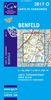
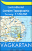
 Sweden
 USA
USA
 Italy
Italy
 Spain
Spain
More From Contributor


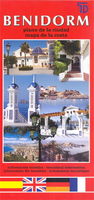
Benidorm
Benidorm on an indexed street plan at 1:9, 700 from Telstar Distrimapas, Spain’s leading publisher of city maps, with an enlargement of the city centre, a road map Blanca, and English language notes about the city and its region.On one side is an indexed street plan of the city with main public buildings and places interest clearly named. Locations of campsites, golf courses, taxi ranks, petrol stations, etc., are highlighted. An enlargement shows the city centre in greater detail. On the reverse is an indexed map of the Costa Blanca at 1:265, 000 with bold altitude colouring showing the topography of its mountainous hinterland, including names of various sierras and peaks. Also marked are numerous beaches. Map legend includes English.

Product Description
Reviews/Comments
Add New
Vouchers
No voucher codes found.
Do you know a voucher code for this product or supplier? Add it to Insights for others to use.
Do you know a voucher code for this product or supplier? Add it to Insights for others to use.
 Denmark