More From Contributor
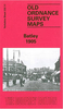
£7.99
Did you know? The planet Uranus was discovered from a back garden in Bath Queen Victoria spurned Bath after its citizens joked about her plump ankles Hollywood star Nicolas Cage, former Prime Minister Pitt the Elder & artist Thomas Gainsborough have all lived on the same Bath street Small but perfectly formed, Bath is a fascinating city with a history stretching back to pre-Roman times. It was the destination of choice for Georgian high society, attracting gamblers, rakes & pleasure-seekers. Today, it is still a popular tourist destination, home to quirky characters, fascinating architecture & an intriguing history. ...
Archived Product
£2.50
Bathgate street map from Nicolson Maps: coverage

Includes::
Blackburn, Boghall, Broxburn, Kirkliston, Newbridge,

...
Archived Product
£2.95
Bathgate in 1896 in a fascinating series of reproductions of old Ordnance Survey plans in the Alan Godfrey Editions, ideal for anyone interested in the history of their neighbourhood or family. Selected towns in Great Britain & Ireland are covered by maps showing the extent of urban development in the last decades of the 19th & early 20th century. In this title: the map is double-sided. The main map covers most of the town, with coverage extending south-east to Kirkroads. Features include NBR Bathgate Section with Upper Station, Polkenmet Junction, Lower Station, mineral railway, Balbardie Collieries Mine, Bridge-end, Easton, disused colliery, Iron Foundry, West Lothian Shovel Works, Bathgate Academy, Balbardie House, etc. On the reverse is about half of the adjacent sheet 9.02 extending coverage northward to include Balbardie Mains, Glenmavis Distillery, Balbardie Pit No.1 & Ballencrieff Mains. About the Alan Godfrey Editions of the 25 ...
Archived Product
£36.95
Military topographic survey mapping with contours. These maps are designed primarily as flying charts for aircraft, but they are useful as general topographical maps where nothing else is available. Contours are shown in feet, with elevation colouring & spot heights. Towns, villages, major roads, railways & airports are shown (but please note that many of the smaller settlements are not named, & the road information is not necessarily up to date). Some air navigation information also appears on the map, such as radio beacons & restricted flying zones. Double-sided sheet. ...
Archived Product
£2.95
Batley in 1892 in a fascinating series of reproductions of old Ordnance Survey plans in the Alan Godfrey Editions, ideal for anyone interested in the history of their neighbourhood or family. Selected towns in Great Britain & Ireland are covered by maps showing the extent of urban development in the last decades of the 19th & early 20th century. In this title: two versions have been published for this area. Each covers most of the town centre, extending north-west to Carlinghow, & west to Healey & Bunkers Hill. Features include the town centre inclunding railway approaches & junction (Batley station is in the extreme south-eastern corner), Bank Foot, Clerk Green, Lamplands, Commercial Street, Market Square, Town Hall, Cheapside Mills & numerous other mills, All Saints church, Farfield Nursery, Blakeridge Mill, cemetery, Cross Bank, tramways, Carlinghow Mills, Victoria Mills, Dock Ing Mills, Bulrush Mills, LNWR Birstall Branch, Grammar School, St John's church, Carlinghow Old Hall, Spring Mill, Healey House, Healey Lane Mill, The Jail, Little Orme Mill etc. Each map

Includes::
a selection of directory entries. About the Alan Godfrey Editions of the 25

...
Archived Product
£3.50
Batley in 1905 in a fascinating series of reproductions of old Ordnance Survey plans in the Alan Godfrey Editions, ideal for anyone interested in the history of their neighbourhood or family. Two versions have been published for this area. Each covers most of the town centre, extending north-west to Carlinghow, & west to Healey & Bunkers Hill. Features include the town centre inclunding railway approaches & junction (Batley station is in the extreme south-eastern corner), Bank Foot, Clerk Green, Lamplands, Commercial Street, Market Square, Town Hall, Cheapside Mills & numerous other mills, All Saints church, Farfield Nursery, Blakeridge Mill, cemetery, Cross Bank, tramways, Carlinghow Mills, Victoria Mills, Dock Ing Mills, Bulrush Mills, LNWR Birstall Branch, Grammar School, St John`s church, Carlinghow Old Hall, Spring Mill, Healey House, Healey Lane Mill, The Jail, Little Orme Mill, etc. Each map has a selection of directory entries. About the Alan Godfrey Editions of the 25” OS Series: Selected towns in Great Britain & Ireland are covered by maps showing the extent of urban development in the last decades of the 19th & early 20th century. The plans have been taken from the Ordnance Survey mapping & reprinted at about 15 inches to one mile (1:4, 340). On the reverse most maps have historical notes & many also include extracts from contemporary directories. Most maps cover about one mile (1.6kms) north/south, one & a half miles (2.4kms) across; adjoining sheets can be combined to provide wider coverage.FOR MORE INFORMATION & A COMPLETE LIST OF ALL AVAILABLE TITLES PLEASE CLICK ON THE SERIES LINK. ...
Archived Product
£19.99
Trapped in a world where they can scarcely tell friend from foe, the Turtles` first encounter with the Dark Knight puts their fighting skills to the ultimate test. While the Shredder is locked away at Riker`s Isl&, the Foot Civil War rages through New York City. Each branch of the Foot is determined to kill the Turtles first, to prove their rightful claim to power. Meanwhile, Batman & Robin are back in the DC Universe, dealing with the repercussions of a massive Arkham Asylum breakout that freed Bane! When Bane is unexpectedly transported to the Turtles` New York City, he swiftly takes control of the city & Batman & the Turtles must unite forces to defeat their common enemy! From the monster creative team behind the original graphic novel, James Tynion IV & Freddie Williams II, this sequel further explores one of the greatest team-ups of all time! Collects issues 1-7. ...
Archived Product
£7.99
Baton Rouge, Shreveport & Bossier City, LA in Louisiana on an indexed street plan from Rand Mc Nally in their extensive range of maps covering cities in the United States. Communities covered by this map include Baker, Port Allen & Zachary. Rand Mc Nally street plans provide coverage of cities with their outer suburbs, clearly indicating main traffic arteries: highways (distinguishing between free & toll access), plus primary & secondary routes. Road numbers and/or names are clearly displayed & exit numbers are indicated. Locations of service & rest areas are marked & one way streets are shown. Longer streets are annotated with block numbers for easier identification of addresses. The maps show railway, bus &, where appropriate, metro stations. A range of symbols indicate various places of interest including cultural & academic institutions, various municipal facilities, golf courses, etc. The plans have extensive street indexes, supplemented by lists of points of interest, parks & recreational areas, shopping malls, stations, schools, etc. ...
Archived Product
£6.50
Baton Rouge, Shreveport & Bossier City, LA in Louisiana on an indexed street plan from Rand Mc Nally in their extensive range of maps covering cities in the United States. Communities covered by this map include Baker, Port Allen & Zachary. Rand Mc Nally street plans provide coverage of cities with their outer suburbs, clearly indicating main traffic arteries: highways (distinguishing between free & toll access), plus primary & secondary routes. Road numbers and/or names are clearly displayed & exit numbers are indicated. Locations of service & rest areas are marked & one way streets are shown. Longer streets are annotated with block numbers for easier identification of addresses. The maps show railway, bus &, where appropriate, metro stations. A range of symbols indicate various places of interest including cultural & academic institutions, various municipal facilities, golf courses, etc. The plans have extensive street indexes, supplemented by lists of points of interest, parks & recreational areas, shopping malls, stations, schools, etc. ...
Archived Product
£4.99
Join the free-for-all fun at the public library with these book-loving bats! Shape shadows on walls, frolic in the water fountain, & roam the book-filled halls until it`s time for everyone, young & old, to settle down into the enchantment of story time. Brian Lies` joyful critters & their nocturnal celebration cast library visits in a new light. Even the youngest of readers will want to join the batty book-fest! ...
Archived Product

Batley 1892

Batley in 1892 in a fascinating series of reproductions of old Ordnance Survey plans in the Alan Godfrey Editions, ideal for anyone interested in the history of their neighbourhood or family. Two versions have been published for this area. Each covers most of the town centre, extending north-west to Carlinghow, and west to Healey and Bunkers Hill. Features include the town centre inclunding railway approaches and junction (Batley station is in the extreme south-eastern corner), Bank Foot, Clerk Green, Lamplands, Commercial Street, Market Square, Town Hall, Cheapside Mills and numerous other mills, All Saints church, Farfield Nursery, Blakeridge Mill, cemetery, Cross Bank, tramways, Carlinghow Mills, Victoria Mills, Dock Ing Mills, Bulrush Mills, LNWR Birstall Branch,
Grammar School, St John`s church, Carlinghow Old Hall, Spring Mill, Healey House, Healey Lane Mill, The Jail, Little Orme Mill, etc. Each map has a selection of directory entries.About the Alan Godfrey Editions of the 25” OS Series:Selected towns in Great Britain and Ireland are covered by maps showing the extent of urban development in the last decades of the 19th and early 20th century. The plans have been taken from the Ordnance Survey mapping and reprinted at about 15 inches to one mile (1:4, 340). On the reverse most maps have historical notes and many also include extracts from contemporary directories. Most maps cover about one mile (1.6kms) north/south, one and a half miles (2.4kms) across; adjoining sheets can be combined to provide wider coverage.FOR MORE INFORMATION
AND A COMPLETE LIST OF ALL AVAILABLE TITLES PLEASE CLICK ON THE SERIES LINK.
RIP - This product is no longer available on our network. It was last seen on 25.09.2019

This page now acts as a permanent archive for this product. Add more information using the comments box below to ensure it can still be found by future generations.

Use our search facility to see if it is available from an alternative contributor.
  • Availability: Out Of Stock
  • Supplier: Stanfords
  • SKU: 9781847846082
Availability: In Stock
£3.50

Product Description

Batley in 1892 in a fascinating series of reproductions of old Ordnance Survey plans in the Alan Godfrey Editions, ideal for anyone interested in the history of their neighbourhood or family. Two versions have been published for this area. Each covers most of the town centre, extending north-west to Carlinghow, & west to Healey & Bunkers Hill. Features include the town centre inclunding railway approaches & junction (Batley station is in the extreme south-eastern corner), Bank Foot, Clerk Green, Lamplands, Commercial Street, Market Square, Town Hall, Cheapside Mills & numerous other mills, All Saints church, Farfield Nursery, Blakeridge Mill, cemetery, Cross Bank, tramways, Carlinghow Mills, Victoria Mills, Dock Ing Mills, Bulrush Mills, LNWR Birstall Branch, Grammar School, St John`s church, Carlinghow Old Hall, Spring Mill, Healey House, Healey Lane Mill, The Jail, Little Orme Mill, etc. Each map has a selection of directory entries. About the Alan Godfrey Editions of the 25” OS Series: Selected towns in Great Britain & Ireland are covered by maps showing the extent of urban development in the last decades of the 19th & early 20th century. The plans have been taken from the Ordnance Survey mapping & reprinted at about 15 inches to one mile (1:4, 340). On the reverse most maps have historical notes & many also include extracts from contemporary directories. Most maps cover about one mile (1.6kms) north/south, one & a half miles (2.4kms) across; adjoining sheets can be combined to provide wider coverage.FOR MORE INFORMATION & A COMPLETE LIST OF ALL AVAILABLE TITLES PLEASE CLICK ON THE SERIES LINK.

Reviews/Comments

Add New

Intelligent Comparison

Oooops!
We couldn't find anything!
Perhaps this product's unique.... Or perhaps we are still looking for comparisons!
Click to bump this page and we'll hurry up.

Price History

Vouchers

No voucher codes found.
Do you know a voucher code for this product or supplier? Add it to Insights for others to use.

Facebook

Jargon Buster

Contemporary - Modern era design
Contemporary - A design reference to indicate post war modern design
Foot - A part of the body at the bottom end of the leg
Foot - or Feet - a measurement equivilent to 30cm
History - Anything that happens in the past. An acedemic subject.
Contemporary - An object that is living in the same time.
Mill - A building which can grind grain into flour.
Junction - A point where two or more things come together, typically used to describe roads
Hall - A room at the inside of an entrance of a house.
Ideal - Something that satisfies a perfect criteria.
Family - A group of people that live together made up from parents and children.

Supplier Information

Stanfords
Stanfords was established in 1853 and opened their iconic Covent Garden flagship store in 1901. They have become the top retailer of maps, travel books and accessories in the UK and arguably offer the largest selection of maps and travel books worldwide. Famous names such as Captain Robert Falcon Scott, Ranulph Fiennes and Michael Palin have purchased from Stanfords. They now have a shop in Bristol and both stores together with other venues operate a calendar of events including talks, book signings and exhibitions. As a specialist map retailer, the map selection is comprehensive and includes road maps, street maps and walking maps from worldwide destinations, as well as a selection of world atlases and wall maps. Books include travel guides and travel literature. Stanfords also stock globes, from miniatures made of blue marble to magnificent floor-standing globes. The website features a selection of interesting articles on travel topics.
Page Updated: 2023-11-12 20:15:36

Community Generated Product Tags

Oh No! The productWIKI community hasn't generated any tags for this product yet!
Menu