
 United Kingdom
 France
 Germany
 Netherlands
 Sweden
 USA
USA
 Italy
Italy
 Spain
Spain
More From Contributor

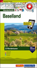


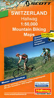
Baselland Mountain Bike Map: Basel - Olten
The southern environs of Basel at 1:50, 000 in a series of waterproof and tear-resistant, contoured mountain biking maps from Hallwag, each highlighting several circuits and providing route profiles, guidance on the difficulty and overall experience, etc. Each map in this series is printed on sturdy, waterproof and tear-resistant plastic, and uses the same detailed base as other hiking and cycling map series from the Hallwag – Kümmerly + Frey publishing house. Contours are at 25m intervals, enhanced by shading and excellent graphic relief to provide a very clear picture of the topography. An overprint highlights several mountain bike circuits from main towns and holiday resorts on the map, indicating the direction of the route. The routes are graded by colour-coding into five
degrees of difficulty. Additional information provided on the map includes youth hostels, Friends of Nature houses or isolated countryside hotels, viewpoints, interesting sites, etc. The maps have a 1-km gird, although no Swiss national survey coordinates are provided for it.On the reverse each of the highlighted circuits is presented on a route-profile which also indicates “beauty and experience value” (changes in landscape, viewpoints, etc); difficulty; overall severity (length + difference in elevation + difficulty); distance; difference in altitude; time required; and the highest point.The legend for the main map and for the route profiles includes English. Brief descriptions of each circuit are in German only.
degrees of difficulty. Additional information provided on the map includes youth hostels, Friends of Nature houses or isolated countryside hotels, viewpoints, interesting sites, etc. The maps have a 1-km gird, although no Swiss national survey coordinates are provided for it.On the reverse each of the highlighted circuits is presented on a route-profile which also indicates “beauty and experience value” (changes in landscape, viewpoints, etc); difficulty; overall severity (length + difference in elevation + difficulty); distance; difference in altitude; time required; and the highest point.The legend for the main map and for the route profiles includes English. Brief descriptions of each circuit are in German only.

Product Description
Reviews/Comments
Add New
Vouchers
No voucher codes found.
Do you know a voucher code for this product or supplier? Add it to Insights for others to use.
Do you know a voucher code for this product or supplier? Add it to Insights for others to use.
 Denmark