More From Contributor
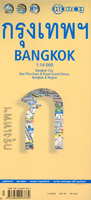
£4.95
Wallpaper City Guides not only suggest where to stay, eat, & drink, but what the tourist passionate about design might want to see, whether he/she has a week or 24 hours in the city. Featured are up & coming areas, landmark buildings in an ' Architour', design centres, & the best shops to buy items unique to that city. Wallpaper City Guides present travellers with a fast-track ticket to the chosen location. The edited guides offer the best, most exciting, & the most beautiful of that particular city. As well as looking beautiful, the guides are expertly designed with function as a priority, & have tabbed sections so that readers can easily find the information they are looking for. The guides include rate & currency information, maps & a colour-coding system to help you navigate the different parts of the city. They are the ultimate combination of form & function. ...
Archived Product
£5.95
Bangkok in the Wallpaper City Guide series, published by Phaidon & encompassing a collection of pocket-size guides dedicated to the best design elements in major cities. Compiled by experts at the Wallpaper magazine, the guides are widely recognized for appealing to design-conscious travellers & are aimed at those interested in art, design & architecture. Each guide identifies the best bars, restaurants, hotels, places to shop, leisure activities & excursions with a unique emphasis on the finest examples of unusual architecture & design. Each Wallpaper City Guide has the same layout, with separate tabs allowing readers & travellers to access individual sections easily. The tabs consist of Landmarks, Hotels, 24 Hours, Urban Life, Architour, Shopping, Sports & Escapes. High quality colour photographs appear alongside brief descriptions of each hotel, bar or attraction, highlighting distinctive & unusual styles of architecture & design. Extra pages are provided at the back of each guide, allowing readers to record their own notes & sketches. ...
Archived Product
£12.99
Bangkok & Beach Escapes in the City & Regions series from Time Out; comprehensive guides to a range of cities & their surrounding regions & including some of the most detailed listings & directories of places to eat & drink & things to do & see. Time Out guides are strongly focussed on local entertainment & nightlife, in addition to principal sights & attractions, with expert local writers providing an encyclopaedic knowledge of each city. This unique quality has ensured that the guides have won a reputation for their accuracy & reliability. The surrounding region is also incorporated in some guides, with information on the principal attractions, sites, landscapes & the best way of exploring them. Each of the Time Out city & region guides has a similar layout, allowing visitors to explore their destination easily. An ...
Archived Product
£10.99
Bangkok on a double-sided map from Nelles combining an indexed street plan at 1:15, 000 of the city’s central districts with a more general plan of the capital with its outer suburbs presented at 1:75, 000. Both plans highlight numerous places of interest. On one side the main, indexed plan covers the city’s inner districts showing public transport routes: metro & skytrain lines with stations, bus routes with line numbers, & express boat service along the river. Public buildings, including selected hotels, are clearly marked & named, & shopping centres or market streets are indicated. The main centre of tourist accommodation, Banglamphoo
- Khao San Road area, is also shown in greater detail on a small enlargement. On the reverse a more general plan at 1:75, 000 covers the city with its outer suburbs, highlighting main traffic arteries, including access to the international airport. Metro, skytrain & express boat lines are marked, plus the suburban railway lines with station names. In addition to information described above, the plan also gives names of numerous industrial & educational establishments, etc. Also provided are details of Chao Phraya Express Boat services. Map legend

Includes::
English.


...
Archived Product
£8.99
Bangkok with its outer suburbs & the surrounding area at 1:82, 000 on a road map from the locally based publishers Thinknet. All place names, including sights & facilities highlighted on the map, are in both Thai & Latin alphabet. The map presents the area’s road network in detail, highlighting main routes & clearly showing the interchanges. Railway lines are shown with stations. Boundaries of local administrative units are marked with their names in large, clearly legible print. The plan indicates numerous public buildings, services or facilities & places of interest, all conveniently colour-coded but with their names in very small size print. ...
Archived Product
£11.50
Bangkok City Atlas from the Thai publishers Thinknet, in a handy A5 paperback format, presenting the metropolitan area at 1:70, 000, central Bangkok at 1:15, 000, & main tourist district of the city at more detailed scales. All names, both of streets or districts & in the very extensive overprint highlighting public buildings & institutions, train stations & other transport information, various facilities including hotels, restaurants, banks, etc. are bilingual in Thai & English. More detailed mapping at various scales is provided for the city ...
Archived Product
£13.99
Bangkok in the City Guide Series from Lonely Planet, profiling in comprehensive detail the history, major sights, best places to eat, nightlife, accommodation & shopping possibilities of an extensive range of cities worldwide. Frank & informal in style, the guides are renowned for their appeal to independent travellers & are written & researched by local authors. Each guide is divided into 11 main sections
- Getting Started, Background, Neighbourhoods, Shopping, Eating, Drinking & Nightlife, The Arts, Sports & Activities, Gay & Lesbian, Sleeping & Day Trips & Excursions. The Background section details the history, arts, architecture, environment, media, fashion & government & politics of the city. An
...
Archived Product
£14.99
Bangkok in the City Guide Series from Lonely Planet, profiling in comprehensive detail the history, major sights, best places to eat, nightlife, accommodation & shopping possibilities of an extensive range of cities worldwide. Frank & informal in style, the guides are renowned for their appeal to independent travellers & are written & researched by local authors. Each guide is divided into 11 main sections
- Getting Started, Background, Neighbourhoods, Shopping, Eating, Drinking & Nightlife, The Arts, Sports & Activities, Gay & Lesbian, Sleeping & Day Trips & Excursions. The Background section details the history, arts, architecture, environment, media, fashion & government & politics of the city. An
...
Archived Product
£12.99
Excursions chapter is great for travelers who want to venture from the busy Thai capital & explore quieter places in the region. Contains content written by Environmental expert David Lukas & foodie Austin Bush. Increased coverage of sustainable travel options throughout the guide. Interviews with an eclectic range of locals to capture the diversity of the city. ...
Archived Product
£4.99
The AA City Map & Mini Guide to Bangkok is a laminated, indexed street plan of Bangkok at Approx. 1:50, 000 scale. The map also

Includes::
information on top tourist attractions & sights, listings of top restaurants, tips on shopping & entertainment venues, & city transport information. Principal streets & roads are marked & named, with main roads highlighted. Parks, lakes & major public buildings are shaded, & symbols show major monuments, historical sights & temples, as well as many of the principal markets & some practical traveller information such as post offices & tourist information centres. City transport services, including the Skytrain routes & stations, railway routes & stations, parking, bus stations & ferry piers are shown. An inset gives a diagrammatic map of the city transport network. The map covers an area of Approx. 20x 19km, Approx. centred on Ratcha Thewi. The multi-lingual legend

Includes::
English.


...
Archived Product

Bangkok Borch

Laminated and waterproof map for visitors to Bangkok from Borch, highlighting top 30 sights in the city and combining a street plan with a road map of the environs of the capital. The street plan at 1:14, 000 covers the city’s inner districts, extending from the west side of the Mae Nam Chao Phraya River and the Thonburi district to beyond the Chalarm Mahanakhon Expressway and from the National Parliament and University buildings to Taksin Bridge. The map highlights numerous places of interest, temples, selected hotels, metro stations, etc. Street names are in Roman alphabet, with names of main avenues, districts and selected places of interest also shown in Thai script. An inset at 1:6, 000 shows the Wat Phra Kaeo and the Royal Grand Palace area in greater detail. On the reverse
is a road map of the city’s environs at 1:100, 000, highlighting main road and motorway routes, numerous temples, etc. Most place names are given in both Roman and Thai alphabets. Both the street plan and the road map are indexed with names of streets/locations and places of interest. Also included is a diagram of the city’s metro lines, a small administrative map of Thailand, and information on the city’s climate.
RIP - This product is no longer available on our network. It was last seen on 25.09.2019

This page now acts as a permanent archive for this product. Add more information using the comments box below to ensure it can still be found by future generations.

Use our search facility to see if it is available from an alternative contributor.
  • External links may include paid for promotion
  • Availability: Out Of Stock
  • Supplier: Stanfords
  • SKU: 9783866093782
Availability: In Stock
£8.99

Product Description

Laminated & waterproof map for visitors to Bangkok from Borch, highlighting top 30 sights in the city & combining a street plan with a road map of the environs of the capital. The street plan at 1:14, 000 covers the city’s inner districts, extending from the west side of the Mae Nam Chao Phraya River & the Thonburi district to beyond the Chalarm Mahanakhon Expressway & from the National Parliament & University buildings to Taksin Bridge. The map highlights numerous places of interest, temples, selected hotels, metro stations, etc. Street names are in Roman alphabet, with names of main avenues, districts & selected places of interest also shown in Thai script. An inset at 1:6, 000 shows the Wat Phra Kaeo & the Royal Grand Palace area in greater detail. On the reverse is a road map of the city’s environs at 1:100, 000, highlighting main road & motorway routes, numerous temples, etc. Most place names are given in both Roman & Thai alphabets. Both the street plan & the road map are indexed with names of streets/locations & places of interest. Also included is a diagram of the city’s metro lines, a small administrative map of Thail&, & information on the city’s climate.

Reviews/Comments

Add New

Intelligent Comparison

Oooops!
We couldn't find anything!
Perhaps this product's unique.... Or perhaps we are still looking for comparisons!
Click to bump this page and we'll hurry up.

Price History

Vouchers

No voucher codes found.
Do you know a voucher code for this product or supplier? Add it to Insights for others to use.

Facebook

Jargon Buster

Waterproof - Resistant to water, usualy specified by depth in metres
Small - something that takes up less space than normal.
Road - a manmade lane or a path that is used to speed up travel.
Laminated - A thin layer of plastic that gives a coating and shine to a material.

Supplier Information

Stanfords
Stanfords was established in 1853 and opened their iconic Covent Garden flagship store in 1901. They have become the top retailer of maps, travel books and accessories in the UK and arguably offer the largest selection of maps and travel books worldwide. Famous names such as Captain Robert Falcon Scott, Ranulph Fiennes and Michael Palin have purchased from Stanfords. They now have a shop in Bristol and both stores together with other venues operate a calendar of events including talks, book signings and exhibitions. As a specialist map retailer, the map selection is comprehensive and includes road maps, street maps and walking maps from worldwide destinations, as well as a selection of world atlases and wall maps. Books include travel guides and travel literature. Stanfords also stock globes, from miniatures made of blue marble to magnificent floor-standing globes. The website features a selection of interesting articles on travel topics.
Page Updated: 2023-11-12 20:15:36

Community Generated Product Tags

Oh No! The productWIKI community hasn't generated any tags for this product yet!
Menu