More From Contributor
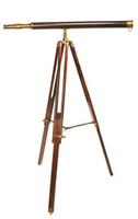
£19.95
Auyuittuq National Park on Baffin Island in Nunavut at 1:300, 000 in a series of GPS compatible recreational maps at various scales from Go Trekkers highlighting recreational possibilities including trekking and/or snowshoe trails, canoeing & kayaking routes, campgrounds, warden stations, etc. Cartography of each title varies according to the terrain of the national park, but the maps are contoured & have spot heights plus, as appropriate, graphics to show wetlands, relief shading in mountainous areas, etc. All the titles are GPS compatible with either a UTM or latitude/longitude grid. Presentation of trails, recreational facilities such as campgrounds, access to the park by road or air, etc, also varies according to what each park has to offer & where it is situated. Each map also

Includes::
notes about the park.IN THIS TITLE: the map provides a vivid picture of the parks topography with contours & relief shading, plus graphics to show areas of permanent snow, moraine, sandy areas, dry rivers & tundra ponds. The main trail is annotated with locations of shelters. The notes provide information about access to the park, when to visit, etc.

...
Archived Product
£9.99
Ava Gardner was one of the most glamorous & famous stars in Hollywood in the 1940s & 1950s. Her list of films

Includes::


...
Archived Product
£9.95
Nicholas Sumner is a photographer whose work has been published in twenty nine travel guide books. This, his first travel narrative, recounts the story of a seven-year journey across Asia in pursuit of beautiful pictures. ” Before I left home, I thought that I knew something about photography, but I found that what knowledge I had was more hindrance than help & I had to admit, that really, I didn`t know anything at all. This was humbling, & a little frightening, but it was also the beginning of a process of discovery in which my expectations as a photographer & as a traveller were constantly challenged, reassessed & revised. ”I experienced moments that were terrifying & sublime, hilarious & tragic. I was mugged, threatened with guns & arrested; I journeyed among mountains, through jungles & cities, I encountered deserts both spiritual & physical, saw things so beautiful that they moved me to tears & received kindness so absolute that I can never repay it. I knew both joy & despair, I ate kangaroo pie, discovered the exact monetary value of my eyebrows & I fell in love. Twice.” His journey became much more than a quest for great images. Travelling & photography are pursuits of the curious, they complement & sometimes conflict with one another but both are driven by a desire to observe & a hunger for insight. Both can touch the spirit, move the heart, & both can reveal truth. ...
Archived Product
£9.99
Robert Bolognesi’s Cicerone guide Avalanche explores the skill of avalanche prediction & is aimed at mountaineers, skiers, climbers, snow-boarders, snowshoers, walkers & all who love winter & snow sports. The guide draws on the expertise of a wide range of professionals involved in mountain activities, as well as first-hand accounts of avalanche scenes fro witnesses & survivors to help readers understand & predict avalanches, evaluate the risks & reduce the dangers. This practical, pocket-sized guide is for use on the mountain & during planning & comes with a practical ‘ Nivo Test’ card designed to help quantify the risk from avalanches. ...
Archived Product
£13.99
This is the companion to Staying Alive in Avalanche Terrain the bestselling avalanche text in the U.S
- with easy-to-understand
...
Archived Product
£17.99
Topographic survey of Portugal at 1:50, 000 from the Instituto Geográfico do Exército, the country’s military survey organisation. The maps have contours at 20m intervals & in addition to the standard features shown on topographic mapping at this scale also indicate various types of terrain or vegetation (s&, terraces, rocks, woodlands, vineyards, etc). Each sheet covers an area of 32 x 20km (20 x 12.5 miles approx). The maps have a 1-km UTM grid plus latitude & longitude coordinates for the map corners. Map legend & a glossary of terms used on the maps include English.EDITION DATES: most titles in this series date from 1990s or later. To see all the titles in this series please click on the series link. ...
Archived Product
£17.99
Topographic survey of Portugal at 1:50, 000 from the Instituto Geográfico Português, the country’s civilian survey organisation. The maps have contours at 25m intervals & in addition to the standard features shown on topographic mapping at this scale also indicate various types of vegetation (vineyards, olive groves, etc). Each sheet covers an area of 32 x 20km (20 x 12.5miles approx). The maps have latitude & longitude margin ticks at 1’ intervals & UTM coordinates for the map corners – each sheet also shows conversion details from BBLx (Bessel-Bonnie system, Datum Lisbon) to UTM. Map legend is in Portuguese only.EDITION DATES: most titles in this series have now been updated in the 1990s or later. To see all the titles in this series please click on the series link. ...
Archived Product
£17.99
Topographic survey of Portugal at 1:100, 000 from the Instituto Geográfico Português, the country’s civilian survey organisation. The maps have contours at 50m intervals & in addition to the standard features shown on topographic mapping at this scale also indicate various types of vegetation (vineyards, olive groves, etc). Each sheet covers an area of 64 x 40km (40 x 25 miles approx). The maps have latitude & longitude margin ticks at 1’ intervals, plus show UTM coordinates for the map corners. Map legend is in Portuguese only.PLEASE NOTE
- EDITION DATES: some sheets at this scale date back to the 1950s or 1960s. For more recent editions please see IGP’s 1:25, 000 series where each 50K map is divided into four quarters. To see all the titles in the 1:100, 000 series please click on the series link.
...
Archived Product
£12.99
Avellino Province at 1:100, 000 in a series of handy size provincial road maps from Litografia Artistica Cartografica (LAC) with more minor local roads & country tracks than can be found on most regional maps from other publishers. This title is now available in a digitally produced edition.LAC’s provincial series is gradually being changed to a new style of digitally derived cartography, so presentation of adjoining titles may vary. All the maps have hill shading to represent the general relief with spot heights for selected peaks, & show a few more local roads & rough tracks than the other road map series. Intermediate road distances are indicated. Regional, provincial & communal borders are marked, & railways, funiculars, airports, sea ferry links & campsites are shown. The legend is in Italian only. The new, digitally produced editions are indexed & have enhanced, more finely drawn cartography: the hill-shading is less bold, motorway service areas are marked, natural parks are highlighted & an expanded range of symbols indicates various landmarks & sites, e.g. antiquities, churches, etc. Two styles of the new cartography are produced, differing only in the colour of the predominant background shading: grey or yellow/green. Some of the new editions include geographical coordinates for the map corners. The index of localities is on the reverse. To see all the titles in this series please click on the series link. ...
Archived Product
£7.95
Avellino Province in a series of handy size road maps from Litografia Artistica Cartografica (LAC) with more minor local roads & tracks than can be found on most regional maps. The series is gradually being changed to a new style of digitally derived cartography, so presentation of adjoining titles may vary. All the maps have hill shading to represent the general relief with spot heights for selected peaks, & show a few more local roads & rough tracks than the other road map series. Intermediate road distances are indicated. Regional, provincial & communal borders are marked, & railways, funiculars, airports, sea ferry links & campsites are shown. The legend is in Italian only. The new, digitally produced editions are indexed & have enhanced, more finely drawn cartography: the hill-shading is less bold, motorway service areas are marked, natural parks are highlighted & an expanded range of symbols indicates various landmarks & sites, e.g. antiquities, churches, etc. Two styles of the new cartography are produced, differing only in the colour of the predominant background shading: grey or yellow/green. Some of the new editions include geographical coordinates for the map corners. The index of localities is on the reverse. This title is still produced in the traditional cartographic style. ...
Archived Product

Avalon Telescope

Authentic Models Avalon Telescope. 100(L) x 82(W) x 156.25(H) cm. This classic telescope is crafted in brass with a rich leather finish. The hand finished rosewood tripod features brass fittings. Magnifies 20X. Doubles a striking and bold décor. An overall quality piece your home cannot do without.If we do not have this item in stock we will order it for you from our supplier. Delivery generally takes 3 weeks within the UK. For overseas delivery queries please email sales@stanfords.co.uk
RIP - This product is no longer available on our network. It was last seen on 25.09.2019

This page now acts as a permanent archive for this product. Add more information using the comments box below to ensure it can still be found by future generations.

Use our search facility to see if it is available from an alternative contributor.
  • External links may include paid for promotion
  • Availability: Out Of Stock
  • Supplier: Stanfords
  • SKU: 0781934577485
Availability: In Stock
£495.00

Product Description

Authentic Models Avalon Telescope. 100 (L) x 82 (W) x 156.25 (H) cm. This classic telescope is crafted in brass with a rich leather finish. The hand finished rosewood tripod features brass fittings. Magnifies 20X. Doubles a striking & bold décor. An overall quality piece your home cannot do without. If we do not have this item in stock we will order it for you from our supplier. Delivery generally takes 3 weeks within the UK. For overseas delivery queries please email sales@stanfords.co.uk

Reviews/Comments

Add New

Intelligent Comparison

Oooops!
We couldn't find anything!
Perhaps this product's unique.... Or perhaps we are still looking for comparisons!
Click to bump this page and we'll hurry up.

Price History

Vouchers

No voucher codes found.
Do you know a voucher code for this product or supplier? Add it to Insights for others to use.

Facebook

Jargon Buster

Leather - Durable and flexible made from the tanning of an animals raw hide
Brass - A copper and Zinc Alloy
UK - United Kingdom - An island nation in Europe
Tripod - A three legged device for supporting an object - commonly a camera.
Hand - A part of the body at the end of the arm
Hand - A pointer which indicates time on a clock face
Cm - Centimetres, one centimetre is equal to 10 milimetres
email - An electronic communication method. Short for Electronic Mail.
delivery - The method by which something is delivered from one location to another
Quality - An object that has quality is superior in function and finish than a less quality object.
Leather - Made from animal hides, is a flexible and durable material
Home - A place of permanent residence for families.
Classic - Something that is still like it was originally a high quality standard.

Supplier Information

Stanfords
Stanfords was established in 1853 and opened their iconic Covent Garden flagship store in 1901. They have become the top retailer of maps, travel books and accessories in the UK and arguably offer the largest selection of maps and travel books worldwide. Famous names such as Captain Robert Falcon Scott, Ranulph Fiennes and Michael Palin have purchased from Stanfords. They now have a shop in Bristol and both stores together with other venues operate a calendar of events including talks, book signings and exhibitions. As a specialist map retailer, the map selection is comprehensive and includes road maps, street maps and walking maps from worldwide destinations, as well as a selection of world atlases and wall maps. Books include travel guides and travel literature. Stanfords also stock globes, from miniatures made of blue marble to magnificent floor-standing globes. The website features a selection of interesting articles on travel topics.
Page Updated: 2023-11-12 20:15:36

Community Generated Product Tags

Oh No! The productWIKI community hasn't generated any tags for this product yet!
Menu