More From Contributor
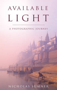
£6.99
Street plan of Auxerre, part of an extensive series covering French cities & towns from Blay-Foldex, the country’s largest, oldest & most experienced publisher of urban mapping. Blay plans include outer suburbs &, where appropriate, adjoining localities forming part of the urban agglomeration & provide brief descriptions of the town’s main sights, contact details for hotels & other places of interest, etc. The plans show one way streets, car parks & pedestrian zones. Important public buildings are clearly marked & identified. Blay street maps are usually double-sided & include an enlargement for the town centre & a street index with separate lists of “edifices publics”: main public buildings, places of worship, schools, sport facilities, stations, etc. Each of the outer suburbs or the adjoining localities, identified with its postcode, has a separate index. Many titles also provide a road map of the environs. All the text is in French only.PLEASE NOTE: to see the list of Blay-Foldex street plans of French towns & cities please click on the series link – the series description also

Includes::
a comparison between Blay & IGN street plans.

...
Archived Product
£8.99
Map No. 128, Auxerre
- Montargis, at 1:100, 000, part of the TOP100 series from the Institut Géographique National (IGN). These
...
Archived Product
£12.99
Topographic survey of France at 1:25, 000 in IGN`s excellent TOP25 / Série Bleue series. All the maps are GPS compatible, with a 1km UTM grid plus latitude & longitude lines at 5’ intervals. Contours are at 5m intervals except for mountainous areas where the maps have contours at 10m intervals, vividly enhanced by hill shading & graphics for rocky terrain. Colouring with graphics indicates different types of vegetation or land use (deciduous or coniferous forests, moors, orchards, vineyards, etc). PLEASE NOTE: coverage of France at this scale is currently being revised – the format & the presentation of each title are indicated by the letters at the end of its Sheet Reference number (e.g. 0416ET, 3531ETR, 1923SB, etc.)MAPS WITH FULL TOURIST OVERPRINT & AN ENGLISH MAP LEGEND: all TOP25 maps & the SB editions of Série Bleue have an overprint highlighting waymarked walking trails including long-distance GR routes &, where appropriate, ski routes. Symbols indicate campsites, gîtes d’etape, refuges, equestrian centres & other recreational facilities or sites, tourist information centres, cultural heritage, etc. Towns & locations of particular interest are highlighted.- ET or OT = single-sided TOP25 map covering approx. 29x 21 km / 18x 13 miles.- ETR or OTR = waterproof & tear resistant TOP25 map covering the same area as the corresponding ET or OT number, but double-sided, printed on a smaller size sheet with a good overlap between the sides.- SB = Série Bleue map with full tourist overprint; these maps, first introduced in summer 2014, each cover approx. 29x 24km / 18x 15 miles.SÉRIE BLEUE maps with numbers ending in E (Est) or O (Ouest): most editions now indicate the GR routes, but do not show any other tourist information. Map legend is in French only. Each map covers approx. 14x 20km / 9x 12 miles. ...
Archived Product
£19.95
Auyuittuq National Park on Baffin Island in Nunavut at 1:300, 000 in a series of GPS compatible recreational maps at various scales from Go Trekkers highlighting recreational possibilities including trekking and/or snowshoe trails, canoeing & kayaking routes, campgrounds, warden stations, etc. Cartography of each title varies according to the terrain of the national park, but the maps are contoured & have spot heights plus, as appropriate, graphics to show wetlands, relief shading in mountainous areas, etc. All the titles are GPS compatible with either a UTM or latitude/longitude grid. Presentation of trails, recreational facilities such as campgrounds, access to the park by road or air, etc, also varies according to what each park has to offer & where it is situated. Each map also

Includes::
notes about the park.IN THIS TITLE: the map provides a vivid picture of the parks topography with contours & relief shading, plus graphics to show areas of permanent snow, moraine, sandy areas, dry rivers & tundra ponds. The main trail is annotated with locations of shelters. The notes provide information about access to the park, when to visit, etc.

...
Archived Product
£9.99
Ava Gardner was one of the most glamorous & famous stars in Hollywood in the 1940s & 1950s. Her list of films

Includes::


...
Archived Product
£9.99
Robert Bolognesi’s Cicerone guide Avalanche explores the skill of avalanche prediction & is aimed at mountaineers, skiers, climbers, snow-boarders, snowshoers, walkers & all who love winter & snow sports. The guide draws on the expertise of a wide range of professionals involved in mountain activities, as well as first-hand accounts of avalanche scenes fro witnesses & survivors to help readers understand & predict avalanches, evaluate the risks & reduce the dangers. This practical, pocket-sized guide is for use on the mountain & during planning & comes with a practical ‘ Nivo Test’ card designed to help quantify the risk from avalanches. ...
Archived Product
£13.99
This is the companion to Staying Alive in Avalanche Terrain the bestselling avalanche text in the U.S
- with easy-to-understand
...
Archived Product
£495.00
Authentic Models Avalon Telescope. 100 (L) x 82 (W) x 156.25 (H) cm. This classic telescope is crafted in brass with a rich leather finish. The hand finished rosewood tripod features brass fittings. Magnifies 20X. Doubles a striking & bold décor. An overall quality piece your home cannot do without. If we do not have this item in stock we will order it for you from our supplier. Delivery generally takes 3 weeks within the UK. For overseas delivery queries please email sales@stanfords.co.uk ...
Archived Product
£17.99
Topographic survey of Portugal at 1:50, 000 from the Instituto Geográfico do Exército, the country’s military survey organisation. The maps have contours at 20m intervals & in addition to the standard features shown on topographic mapping at this scale also indicate various types of terrain or vegetation (s&, terraces, rocks, woodlands, vineyards, etc). Each sheet covers an area of 32 x 20km (20 x 12.5 miles approx). The maps have a 1-km UTM grid plus latitude & longitude coordinates for the map corners. Map legend & a glossary of terms used on the maps include English.EDITION DATES: most titles in this series date from 1990s or later. To see all the titles in this series please click on the series link. ...
Archived Product
£17.99
Topographic survey of Portugal at 1:50, 000 from the Instituto Geográfico Português, the country’s civilian survey organisation. The maps have contours at 25m intervals & in addition to the standard features shown on topographic mapping at this scale also indicate various types of vegetation (vineyards, olive groves, etc). Each sheet covers an area of 32 x 20km (20 x 12.5miles approx). The maps have latitude & longitude margin ticks at 1’ intervals & UTM coordinates for the map corners – each sheet also shows conversion details from BBLx (Bessel-Bonnie system, Datum Lisbon) to UTM. Map legend is in Portuguese only.EDITION DATES: most titles in this series have now been updated in the 1990s or later. To see all the titles in this series please click on the series link. ...
Archived Product

Available Light

Nicholas Sumner is a photographer whose work has been published in twenty nine travel guide books. This, his first travel narrative, recounts the story of a seven-year journey across Asia in pursuit of beautiful pictures. ”Before I left home, I thought that I knew something about photography, but I found that what knowledge I had was more hindrance than help and I had to admit, that really, I didn`t know anything at all. This was humbling, and a little frightening, but it was also the beginning of a process of discovery in which my expectations as a photographer and as a traveller were constantly challenged, reassessed and revised. ”I experienced moments that were terrifying and sublime, hilarious and tragic. I was mugged, threatened with guns and arrested; I journeyed among
mountains, through jungles and cities, I encountered deserts both spiritual and physical, saw things so beautiful that they moved me to tears and received kindness so absolute that I can never repay it. I knew both joy and despair, I ate kangaroo pie, discovered the exact monetary value of my eyebrows and I fell in love. Twice.” His journey became much more than a quest for great images.Travelling and photography are pursuits of the curious, they complement and sometimes conflict with one another but both are driven by a desire to observe and a hunger for insight. Both can touch the spirit, move the heart, and both can reveal truth.
RIP - This product is no longer available on our network. It was last seen on 25.09.2019

This page now acts as a permanent archive for this product. Add more information using the comments box below to ensure it can still be found by future generations.

Use our search facility to see if it is available from an alternative contributor.
  • External links may include paid for promotion
  • Availability: Out Of Stock
  • Supplier: Stanfords
  • SKU: 9781780881577
Availability: In Stock
£9.95

Product Description

Nicholas Sumner is a photographer whose work has been published in twenty nine travel guide books. This, his first travel narrative, recounts the story of a seven-year journey across Asia in pursuit of beautiful pictures. ” Before I left home, I thought that I knew something about photography, but I found that what knowledge I had was more hindrance than help & I had to admit, that really, I didn`t know anything at all. This was humbling, & a little frightening, but it was also the beginning of a process of discovery in which my expectations as a photographer & as a traveller were constantly challenged, reassessed & revised. ”I experienced moments that were terrifying & sublime, hilarious & tragic. I was mugged, threatened with guns & arrested; I journeyed among mountains, through jungles & cities, I encountered deserts both spiritual & physical, saw things so beautiful that they moved me to tears & received kindness so absolute that I can never repay it. I knew both joy & despair, I ate kangaroo pie, discovered the exact monetary value of my eyebrows & I fell in love. Twice.” His journey became much more than a quest for great images. Travelling & photography are pursuits of the curious, they complement & sometimes conflict with one another but both are driven by a desire to observe & a hunger for insight. Both can touch the spirit, move the heart, & both can reveal truth.

Reviews/Comments

Add New

Intelligent Comparison

Oooops!
We couldn't find anything!
Perhaps this product's unique.... Or perhaps we are still looking for comparisons!
Click to bump this page and we'll hurry up.

Price History

Vouchers

No voucher codes found.
Do you know a voucher code for this product or supplier? Add it to Insights for others to use.

Facebook

Jargon Buster

Physical - Used to describe strength or visual properties of an item
Year - The time it takes the planet earth to orbit the sun. This takes around 365.25 days.
Heart - An organ that pumps blood around the body. Usually related to love.
Love - Someone who shows deep affection for someone else.
Home - A place of permanent residence for families.
Year - 365 days (366 days in a leap year), the time taken for planet earth to make one full revolution around the sun.

Supplier Information

Stanfords
Stanfords was established in 1853 and opened their iconic Covent Garden flagship store in 1901. They have become the top retailer of maps, travel books and accessories in the UK and arguably offer the largest selection of maps and travel books worldwide. Famous names such as Captain Robert Falcon Scott, Ranulph Fiennes and Michael Palin have purchased from Stanfords. They now have a shop in Bristol and both stores together with other venues operate a calendar of events including talks, book signings and exhibitions. As a specialist map retailer, the map selection is comprehensive and includes road maps, street maps and walking maps from worldwide destinations, as well as a selection of world atlases and wall maps. Books include travel guides and travel literature. Stanfords also stock globes, from miniatures made of blue marble to magnificent floor-standing globes. The website features a selection of interesting articles on travel topics.
Page Updated: 2023-11-12 20:15:36

Community Generated Product Tags

Oh No! The productWIKI community hasn't generated any tags for this product yet!
Menu