
 United Kingdom
 France
 Germany
 Netherlands
 Sweden
 USA
USA
 Italy
Italy
 Spain
Spain
More From Contributor


Australia
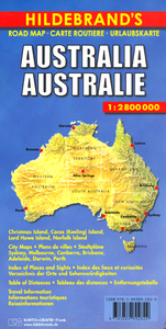
Australia at 1:2, 800, 000 on a large, double-sided road map from Hildebrand with a vivid presentation of the country’s topography, an index which includes places of interest, street plans and/or suburbs maps of main cities, a comprehensive distance table, two general maps of the whole country, plus maps of the offshore islands.The map divides the country east/west, with Alice Springs included on both sides. Bold relief shading shows the topography, with plenty of names of individual mountain ranges, deserts, etc. The map shows the boundaries of national parks and other protected areas, Aboriginal lands, plus restricted entry areas. Road network presents the main highways with their numbers and names, and includes connecting regional roads plus selected smaller local roads.
Driving distances are marked on main and regional routes. Main railway lines such as The Ghan or Trans-Australian are marked, also local airports. The map indicates interesting towns, UNESCO World Heritage sites, etc. Latitude and longitude lines are drawn at 2º intervals. The index has a separate list of places of interest. Map legend includes English.Also provided are: suburb maps of Sydney, Melbourne, Brisbane, Adelaide, Perth, Darwin and Canberra, plus for Sydney and Melbourne also city centre street plans; a state map of Australia, also indicating time zones; an overview map of Australia showing principal road and rail connections; a comprehensive distance table; plus panels with maps of Australia’s offshore islands.
Driving distances are marked on main and regional routes. Main railway lines such as The Ghan or Trans-Australian are marked, also local airports. The map indicates interesting towns, UNESCO World Heritage sites, etc. Latitude and longitude lines are drawn at 2º intervals. The index has a separate list of places of interest. Map legend includes English.Also provided are: suburb maps of Sydney, Melbourne, Brisbane, Adelaide, Perth, Darwin and Canberra, plus for Sydney and Melbourne also city centre street plans; a state map of Australia, also indicating time zones; an overview map of Australia showing principal road and rail connections; a comprehensive distance table; plus panels with maps of Australia’s offshore islands.

Product Description
Reviews/Comments
Add New
Vouchers
No voucher codes found.
Do you know a voucher code for this product or supplier? Add it to Insights for others to use.
Do you know a voucher code for this product or supplier? Add it to Insights for others to use.
 Denmark