
 United Kingdom
 France
 Germany
 Netherlands
 Sweden
 USA
USA
 Italy
Italy
 Spain
Spain
More From Contributor


Australia F&B
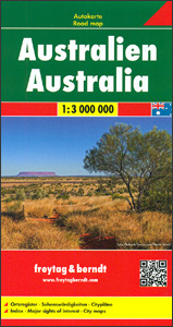
Australia at 1:3, 000, 000 on a large, double-sided map from Freytag & Berndt, with city centre street plans of Sydney, Melbourne, Brisbane, Adelaide, Perth and Darwin, plus and index in a separate booklet attached to the map cover.The map divides Australia east/west with Alice Springs shown on both sides. The country’s numerous national parks and other protected areas, as well as Aboriginal lands are prominently highlighted. Topography is indicated by light shading plus graphics for deserts and plenty of names of mountain ranges, etc. Road network is presented with an unusually large number of intermediate driving distances, marked even on many small local roads and Outback tracks. Main railway lines are included. Symbols indicate various facilities and places of interest,
including selected campsites and caravan parks, roadside accommodation, fuel supplies, etc. The map has latitude and longitude lines at 1º intervals. The index is in a separate booklet attached to the map cover. Map legend includes English. The central districts of Australia’s six main cities are covered street plans and the map also includes small panels showing at 1:1, 500, 000 the country’s offshore islands in the Pacific.
including selected campsites and caravan parks, roadside accommodation, fuel supplies, etc. The map has latitude and longitude lines at 1º intervals. The index is in a separate booklet attached to the map cover. Map legend includes English. The central districts of Australia’s six main cities are covered street plans and the map also includes small panels showing at 1:1, 500, 000 the country’s offshore islands in the Pacific.

Product Description
Reviews/Comments
Add New
Vouchers
No voucher codes found.
Do you know a voucher code for this product or supplier? Add it to Insights for others to use.
Do you know a voucher code for this product or supplier? Add it to Insights for others to use.
 Denmark