More From Contributor

£9.99
Eastern Australia at 1:1, 970, 000 in a series of Adventure maps from the National Geographic Society with cartography provided by Reise Know-How. The map is double-sided & printed on light waterproof & tear-resistant synthetic paper. Cartographic information provided by Reise Know-How has been adjusted to follow the house style of the NGS Adventure series with greater emphasis on the country’s topography. Altitude colouring in broader bands has been replaced here by contours at 200m intervals & relief shading. National parks & other protected areas as well as Aboriginal lands are prominently highlighted. The map divides eastern Australia north/south with a small overlap between the sides. Principal highways & many local roads & outback tracks are named, with driving distances shown on main routes. Railway lines are included & local airports are marked. The map indicates various places of interest, has latitude & longitude grid at intervals of 1° & is indexed.PLEASE NOTE: to ensure faster delivery to our customers we keep this title in regular stock in the Reise Know-How version. The NGS versions can be ordered on request. ...
Archived Product
£14.99
East Coast Australia in the Handbooks series from Footprint; comprehensive & leading guides designed & written for independent travellers who enjoy exploring off the beaten track. Footprint guides have an established reputation, built up since 1921, for catering for more adventurous & individual travellers. An unrestrictive editorial style also gives authors the freedom to capture & explore local cultures, sights & areas that are often not covered in other guides. Widely recognised for their reliability & independent writing style, Footprint guides all have the same layout. Introductory sections introduce the reader to the destination, with chapters on planning on your trip & essentials, including practical information & guidance on subjects such as when & where to go, itineraries, sport & activities, arts, getting there & around, eating & drinks, sleeping & a dedicated section on the anticipated carbon footprint involved in travelling to the destination. Each guide is organised geographically by region or country, with individual sections having a particular focus on an extensive range of sights & places of interest. Further, there are also details of accommodation, nightlife, restaurants & any notable local activities. Information boxes throughout the text give readers an insight into local customs, stories & sights of particular interest.A ...
Archived Product
£14.99
East Coast Australia in the Handbooks series from Footprint; comprehensive & leading guides designed & written for independent travellers who enjoy exploring off the beaten track. Footprint guides have an established reputation, built up since 1921, for catering for more adventurous & individual travellers. An unrestrictive editorial style also gives authors the freedom to capture & explore local cultures, sights & areas that are often not covered in other guides. Widely recognised for their reliability & independent writing style, Footprint guides all have the same layout. Introductory sections introduce the reader to the destination, with chapters on planning on your trip & essentials, including practical information & guidance on subjects such as when & where to go, itineraries, sport & activities, arts, getting there & around, eating & drinks, sleeping & a dedicated section on the anticipated carbon footprint involved in travelling to the destination. Each guide is organised geographically by region or country, with individual sections having a particular focus on an extensive range of sights & places of interest. Further, there are also details of accommodation, nightlife, restaurants & any notable local activities. Information boxes throughout the text give readers an insight into local customs, stories & sights of particular interest.A ‘ Background’ section explores the history, economy, government, education, culture, people, land & environment of the destination in significant depth. There is also a ‘ Footnotes’ chapter with a basic language guide for travellers & information about the author. A useful distance chart tailored to the destination is also included in the inside back cover. * Please note:* the series is gradually being revised, reverting to its previous style of ” Handbooks”, published in a hardback format. ...
Archived Product
£9.99
This is a brand new title for ITMB & is based on the travel reality that most visitors to Australia concentrate on Queensland & New South Wales. This double-sided map begins at Australia s northernmost point of Cape York & proceeds southward through Queensl&, New South Wales, & Victoria; in essence covering the portion of the country dominated by Brisbane, Sydney, & Melbourne, all of which are included as largish inset maps. As a bonus, Tasmania is included as a large inset. The scale is generous, making the map easy to read, & while this map will not meet some expectations, 90% of all visitors to Australia concentrate all their travel within the limits of this map. Why get a map of all of Australia if you`re only visiting the eastern area? ...
Archived Product
£9.50
Indexed, waterproof & tear-resistant road map Eastern Australia with topographic & tourist information, published by Reise Know-How as part of their highly acclaimed World Mapping Project. The map is double-sided to provide the best balance between a good scale & a convenient size sheet. On one side are most of Victoria, New South Wales & southern Queensland to beyond Bundaberg, with Tasmania as an inset, extending westwards to just beyond 143 ...
Archived Product
£5.99
Australia in the Essential Guides Series from the AA, exploring the best places to see & things to do in a range of popular destinations. Each illustrated, pocket-sized guide is divided into five sections
- the essence of the area, planning your trip, the best places to see, best things to do & an exploration of notable highlights, organised by area. An introductory chapter profiles each destination &

Includes::
notes on local cuisine & recommendations for short breaks. A planning section advises on pre-trip preparations & getting there & around as well as outlining useful language tips & what


...
Archived Product
£16.99
Australia in the Eyewitness guide series from Dorling Kindersley; lavishly illustrated & particularly concerned with providing the visitor with detailed background information to sightseeing in the chosen destination & a broad cultural introduction. Popular historical buildings & museums are often described with cutaway diagrams allowing you to view ...
Archived Product
£12.74
Australia in the Eyewitness guide series from Dorling Kindersley; lavishly illustrated & particularly concerned with providing the visitor with detailed background information to sightseeing in the chosen destination & a broad cultural introduction. Popular historical buildings & museums are often described with cutaway diagrams allowing you to view ...
Archived Product
£16.99
DUE OUT MARCH 2014
- Australia in the Eyewitness guide series from Dorling Kindersley; lavishly illustrated & particularly concerned
...
Archived Product
£10.99
Australia at 1:3, 000, 000 on a large, double-sided map from Freytag & Berndt, with city centre street plans of Sydney, Melbourne, Brisbane, Adelaide, Perth & Darwin, plus & index in a separate booklet attached to the map cover. The map divides Australia east/west with Alice Springs shown on both sides. The country’s numerous national parks & other protected areas, as well as Aboriginal lands are prominently highlighted. Topography is indicated by light shading plus graphics for deserts & plenty of names of mountain ranges, etc. Road network is presented with an unusually large number of intermediate driving distances, marked even on many small local roads & Outback tracks. Main railway lines are included. Symbols indicate various facilities & places of interest, including selected campsites & caravan parks, roadside accommodation, fuel supplies, etc. The map has latitude & longitude lines at 1º intervals. The index is in a separate booklet attached to the map cover. Map legend

Includes::
English. The central districts of Australia’s six main cities are covered street plans & the map also

Includes::
small panels showing at 1:1, 500, 000 the country’s offshore islands in the Pacific.


...
Archived Product

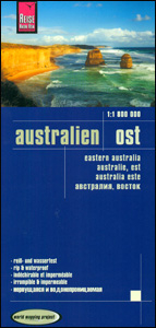
Australia Eastern Reise Know-How

Indexed, waterproof and tear-resistant road map Eastern Australia at 1:1, 800, 000 with topographic and tourist information, published by Reise Know-How as part of their highly acclaimed World Mapping Project. The map is double-sided to provide the best balance between a good scale and a convenient size sheet. On one side are most of Victoria, New South Wales and southern Queensland to beyond Bundaberg, with Tasmania as an inset, extending westwards to just beyond 143º. On the reverse the map shows tropical Queensland and the Great Barrier Reef, extending inland to 141º. The area’s topography is shown by altitude colouring with contours, spot heights, mountain passes, names of mountain ranges, swamps, seasonal salt and fresh water lakes, etc. Bathymetric contours are also
shown and along the Great Barrier Reef names of individual reefs and passages are indicated.Road network includes selected minor local roads, shows intermediate driving distances on motorways and main roads, gives names of the highways connecting main cities, and indicates locations of fuels supplies in more remote areas. The map also shows the rail network and local airfields. Numerous national and state parks, including marine parks, are marked, as well as aboriginal land and restricted access military zones. Symbols highlight various places of interest, viewpoints, springs and waterfalls, botanical gardens, natural curiosities, etc. The map has a latitude/longitude grid at intervals of 1º and an index of localities. Map legend includes English.PLEASE NOTE: Reise Know-How’s
maps of Eastern and Western Australia at 1:1, 800, 000 when combined do not provide coverage of the whole country but leave a large gap in the middle, particularly in the north.
RIP - This product is no longer available on our network. It was last seen on 25.09.2019

This page now acts as a permanent archive for this product. Add more information using the comments box below to ensure it can still be found by future generations.

Use our search facility to see if it is available from an alternative contributor.
  • External links may include paid for promotion
  • Availability: Out Of Stock
  • Supplier: Stanfords
  • SKU: 9783831773381
Availability: In Stock
£11.50

Product Description

Indexed, waterproof & tear-resistant road map Eastern Australia at 1:1, 800, 000 with topographic & tourist information, published by Reise Know-How as part of their highly acclaimed World Mapping Project. The map is double-sided to provide the best balance between a good scale & a convenient size sheet. On one side are most of Victoria, New South Wales & southern Queensland to beyond Bundaberg, with Tasmania as an inset, extending westwards to just beyond 143º. On the reverse the map shows tropical Queensland & the Great Barrier Reef, extending inland to 141º. The area’s topography is shown by altitude colouring with contours, spot heights, mountain passes, names of mountain ranges, swamps, seasonal salt & fresh water lakes, etc. Bathymetric contours are also shown & along the Great Barrier Reef names of individual reefs & passages are indicated. Road network

Includes::
selected minor local roads, shows intermediate driving distances on motorways & main roads, gives names of the highways connecting main cities, & indicates locations of fuels supplies in more remote areas. The map also shows the rail network & local airfields. Numerous national & state parks, including marine parks, are marked, as well as aboriginal land & restricted access military zones. Symbols highlight various places of interest, viewpoints, springs & waterfalls, botanical gardens, natural curiosities, etc. The map has a latitude/longitude grid at intervals of 1º & an index of localities. Map legend

Includes::
English.PLEASE NOTE: Reise Know-How’s maps of Eastern & Western Australia at 1:1, 800, 000 when combined do not provide coverage of the whole country but leave a large gap in the middle, particularly in the north.

Reviews/Comments

Add New

Intelligent Comparison

Oooops!
We couldn't find anything!
Perhaps this product's unique.... Or perhaps we are still looking for comparisons!
Click to bump this page and we'll hurry up.

Price History

Vouchers

No voucher codes found.
Do you know a voucher code for this product or supplier? Add it to Insights for others to use.

Facebook

Jargon Buster

water - A chemical substance. Chemical formula H2O.
Waterproof - Resistant to water, usualy specified by depth in metres
World - A physical grouping, commonly used to describe earth and everything associated with ti
Size - is the measurement of how big an object is in space.
Natural - not manmade
Network - A link and communication between things. Often computers or people.
Large - something that takes up more space than normal.
Road - a manmade lane or a path that is used to speed up travel.
Resistant - Something that can repel against something.
Altitude - Something that can be quite high in relation to sea or ground level.
Tropical - Coming fro the work "tropics" a hot and humid area of the world.
Balance - Something that is evenly weighted to keep something upright.
Individual - A single separate item or person.
Convenient - Something that suits and fits well to other activities.

Supplier Information

Stanfords
Stanfords was established in 1853 and opened their iconic Covent Garden flagship store in 1901. They have become the top retailer of maps, travel books and accessories in the UK and arguably offer the largest selection of maps and travel books worldwide. Famous names such as Captain Robert Falcon Scott, Ranulph Fiennes and Michael Palin have purchased from Stanfords. They now have a shop in Bristol and both stores together with other venues operate a calendar of events including talks, book signings and exhibitions. As a specialist map retailer, the map selection is comprehensive and includes road maps, street maps and walking maps from worldwide destinations, as well as a selection of world atlases and wall maps. Books include travel guides and travel literature. Stanfords also stock globes, from miniatures made of blue marble to magnificent floor-standing globes. The website features a selection of interesting articles on travel topics.
Page Updated: 2023-11-12 20:15:36

Community Generated Product Tags

Oh No! The productWIKI community hasn't generated any tags for this product yet!
Menu