More From Contributor
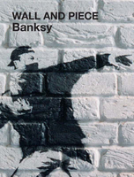
£5.99
This attractive & cleverly structured guide gives walkers ten of the finest walks to the ten most spectacular lighthouses in Wales in a popular pocketable format. With clear information, an overview & introduction for each walk, expertly written numbered directions, large scale Ordnance Survey maps, superb eye-grabbingpanoramic photographs, & interpretation of points of interest along the way, these guides set a new standard in clarity & ease-of-use. ...
Archived Product
£5.99
This attractive & cleverly structured guide gives walkers the ten best walks to the most stunning viewpoints in the Peak District ...
Archived Product
£5.99
This attractive & cleverly structured guide gives walkers ten of the finest walks to the most amazing viewpoints in the Lake District National Park in a popular, pocketable format. With clear information, an overview & introduction for each walk, expertly written numbered directions, large scale Ordnance Survey maps, superb eye-grabbing panoramic photographs, & interpretation of points of interest along the way, these guides set a new standard in clarity & ease-of-use. Featured walks include: Gummer`s How, Carron Crag, Orrest Head, Wastwater, Rannerdale Knotts, Low Fell, Hallin Fell, Walla Crag, Latrigg & Great Mell Fell. ...
Archived Product
£4.99
This attractive & cleverly structured guide gives walkers ten of the finest walks through the historic landscapes of the Lake District National Park in a popular pocketable format. With clear information, an overview & introduction for each walk, expertly written numbered directions, large scale Ordnance Survey maps, superb, eye-grabbing panoramic photographs, & interpretation of points of interest along the way, these guides set a new standard in clarity & ease-of-use. Featured walks include: Castlerigg stone circle, Moor Divock stone circle, Carrock Fell hillfort, Hardknott Roman fort, Viking Gosforth, Medieval Shap Abbey, Kentmere pele tower, Catbells Elizabethan mines, Stott Park Bobbin Mill, & Victorian Loughrigg Tarn. ...
Archived Product
£5.99
ne in the Peak District: Top 10 Walks series. Handy, pocket-sized, full colour walking guides written by experts. With clear information, an overview & introduction for each walk, expertly written numbered directions, large scale Ordnance Survey maps, superb, eye-grabbing panoramic photographs, & interpretation of points of interest along the way, these guides set a new standard in clarity & ease-of-use. Featured walks include: Lyme Park, Longdendale, Carl Wark, Eyam, Macclesfield Forest Chapel, The Magpie Mine, Chatsworth, Lud`s Church, Pilsbury Castle, & Nine Ladies Stone Circle. ...
Archived Product
£175.00
A cloth-backed reproduction by Old Folding Maps of Stanford’s Map of the County of London, According to the Local Government Act 1888, to give it its full title, (large size
- 128.5 x 85.5cm / 50.5” x 33.5” approx) presenting the administrative division of the capital & indicating the boundaries of both the Electoral Divisions returning two members to the County Council & of the Urban Sanitary Districts with control of main roads under the Highways & Locomotives (Amendment) Act of 1878. The map is fixe to hand finished wood hanging bars & bronze plated hanging ring. It measures 115x 78cm/45”x 31” & reaches 118x 83cm/46.5”x 33” with the hanging poles. The colouring & the boundaries are overlaid on a street plan with names of main & selected smaller streets, graphics indicating parks & other common l&, railway lines, etc. Hachures show the topography with the hills of north & south London clearly marked. This is London which, administratively, extends north of the Thames between Hammersmith, Hampstead, Stamford Hill & Poplar, & south of the river between Putney, Streatham, Lower Sydenham & Eltham (although the map itself extends a bit further out, particularly in the north-east). An interesting feature is the inclusion within the County of London of a small area outside its overall boundary – the site of the present day Leg of Mutton Nature Reserve in Barnes.PLEASE NOTE: this title is also available in paper version.
...
Archived Product
£299.99
Edward Stanford first published this decorative map of London in the 1870s. Extending from Hammersmith in the west to the Isle of Dogs in the East & Highgate in the north to South Norwood in the south. It is a highly detailed large scale map & this edition is dated 1878. The north west is still surrounded by fields & Fulham is largely made up of market gardens. ...
Archived Product
£175.00
A cloth-backed reproduction by Old Folding Maps of Stanford’s Map of the County of London, According to the Local Government Act 1888, to give it its full title, (large size
- 128.5 x 85.5cm / 50.5” x 33.5” approx) presenting the administrative division of the capital & indicating the boundaries of both the Electoral Divisions returning two members to the County Council & of the Urban Sanitary Districts with control of main roads under the Highways & Locomotives (Amendment) Act of 1878. The map is fixe to hand finished wood hanging bars & bronze plated hanging ring. It measures 115x 78cm/45”x 31” & reaches 118x 83cm/46.5”x 33” with the hanging poles. The colouring & the boundaries are overlaid on a street plan with names of main & selected smaller streets, graphics indicating parks & other common l&, railway lines, etc. Hachures show the topography with the hills of north & south London clearly marked. This is London which, administratively, extends north of the Thames between Hammersmith, Hampstead, Stamford Hill & Poplar, & south of the river between Putney, Streatham, Lower Sydenham & Eltham (although the map itself extends a bit further out, particularly in the north-east). An interesting feature is the inclusion within the County of London of a small area outside its overall boundary – the site of the present day Leg of Mutton Nature Reserve in Barnes.PLEASE NOTE: this title is also available in paper version.
...
Archived Product
£299.99
A cloth-backed reproduction by Old Folding Maps of “ The World on Mercator’s Projection” map published by James Wyld in 1861 with hand finished wood hanging bars. The map presents the world with international borders highlighted in colour. Hachures indicate main mountain ranges & the map

Includes::
plenty of place names, particularly in the coastal regions & in the already well-explored Pacific Ocean. The interior of Africa is still largely unknown. In USA the map shows individual states; in Australia the south-eastern states are already marked, but the west of the country is still called New Holl&.PLEASE NOTE: This title is also available in a folded version. This reproduction was taken from what used to be called a “cloth-dissected” map, made when the map itself was cut into sections & each section then individually pasted onto an overall cloth backing for the whole map. In this version the whole map is backed onto cloth in one piece but the gaps between the sections have been reproduced in the printing to preserve the style & the feeling of the original. Each individual cloth-backed map is ready to hang & features hand finished wood bars & bronze plated hanging ring. To see the list of all the titles in this series from the Old Folding Maps please click on the series link.

...
Archived Product
£2.95
Wall Heath in 1900 in a fascinating series of reproductions of old Ordnance Survey plans in the Alan Godfrey Editions, ideal for anyone interested in the history of their neighbourhood or family. Selected towns in Great Britain & Ireland are covered by maps showing the extent of urban development in the last decades of the 19th & early 20th century. In this title: the map covers the village of Wall Heath in Kingswinford parish. Coverage stretches from Holbeche House southward to Ashwood House & Dawley Brook, & from Hinksford Farm eastward to Stalling's Farm & Himley Colliery. The area is best known for Holbeche or Holbeach House, where the Gunpowder Plot particpants were arrested. Other features include mineral railway with sidings into sand pits, Wall Heath Forge, Dawleybrook Wharf, Heathbrook arm, Himley Colliery Pits 7 & 8, Elmtree House etc. On the reverse is a directory of Kingswinford & Wall Heath. About the Alan Godfrey Editions of the 25 ...
Archived Product

Wall And Piece

Artistic genius, political activist, painter and decorator, mythic legend or notorious graffiti artist? The work of Banksy is unmistakable, except maybe when it`s squatting in the Tate or New York`s Metropolitan Museum. Banksy is responsible for decorating the streets, walls, bridges and zoos of towns and cites throughout the world. Witty and subversive, his stencils show monkeys with weapons of mass destruction, policeman with smiley faces, rats with drills and umbrellas. If you look hard enough, you`ll find your own. His statements, incitements, ironies and epigrams are by turns intelligent and cheeky comments on everything from the monarchy and capitalism to the war in Iraq and farm animals. His identity remains unknown, but his work is prolific. Here`s the best of his work
in a fully illustrated colour volume - including brand material.
RIP - This product is no longer available on our network. It was last seen on 25.09.2019

This page now acts as a permanent archive for this product. Add more information using the comments box below to ensure it can still be found by future generations.

Use our search facility to see if it is available from an alternative contributor.
  • Availability: Out Of Stock
  • Supplier: Stanfords
  • SKU: 9781844137879
Availability: In Stock
£14.99

Product Description

Artistic genius, political activist, painter & decorator, mythic legend or notorious graffiti artist? The work of Banksy is unmistakable, except maybe when it`s squatting in the Tate or New York`s Metropolitan Museum. Banksy is responsible for decorating the streets, walls, bridges & zoos of towns & cites throughout the world. Witty & subversive, his stencils show monkeys with weapons of mass destruction, policeman with smiley faces, rats with drills & umbrellas. If you look hard enough, you`ll find your own. His statements, incitements, ironies & epigrams are by turns intelligent & cheeky comments on everything from the monarchy & capitalism to the war in Iraq & farm animals. His identity remains unknown, but his work is prolific. Here`s the best of his work in a fully illustrated colour volume
- including brand material.

Reviews/Comments

Add New

Intelligent Comparison

Oooops!
We couldn't find anything!
Perhaps this product's unique.... Or perhaps we are still looking for comparisons!
Click to bump this page and we'll hurry up.

Price History

Vouchers

No voucher codes found.
Do you know a voucher code for this product or supplier? Add it to Insights for others to use.

Facebook

Jargon Buster

New York - A United States State. Commonly known as the Big Apple
Wall - A physical barrier between two areas
World - A physical grouping, commonly used to describe earth and everything associated with ti
Colour - The categorised spectrum of light visable to humans
Museum - A building which exhibits old artefacts for viewing of people who show interest.

Supplier Information

Stanfords
Stanfords was established in 1853 and opened their iconic Covent Garden flagship store in 1901. They have become the top retailer of maps, travel books and accessories in the UK and arguably offer the largest selection of maps and travel books worldwide. Famous names such as Captain Robert Falcon Scott, Ranulph Fiennes and Michael Palin have purchased from Stanfords. They now have a shop in Bristol and both stores together with other venues operate a calendar of events including talks, book signings and exhibitions. As a specialist map retailer, the map selection is comprehensive and includes road maps, street maps and walking maps from worldwide destinations, as well as a selection of world atlases and wall maps. Books include travel guides and travel literature. Stanfords also stock globes, from miniatures made of blue marble to magnificent floor-standing globes. The website features a selection of interesting articles on travel topics.
Page Updated: 2023-11-12 20:15:36

Community Generated Product Tags

Oh No! The productWIKI community hasn't generated any tags for this product yet!
Menu