More From Contributor
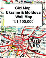
£14.99
Discover Ukraine
Feast your eyes on Scythian gold & mummified monks at Kyiv's Caves Monastery
Descend to the underground

...
Archived Product
£14.99
This fully updated guide will keep you up to speed with this rapidly evolving country. It features comprehensive practical information, while revealing the country's personality through in-depth exploration of its history, culture & natural beauty. Traditional churches, monasteries & sacred sites provide a contrast to the notorious, but compelling, landmark of Chernobyl. Andrew Evans shows how Ukraine can easily be explored by rail, river cruise or sea ferry, & also on foot
- the ideal way to take in rustic villages of old-world eastern Europe.
...
Archived Product
£7.50
Ukraine, Belorussia & Moldova at 1:2, 000, 000 from the Budapest based Catrographia on a useful overview road map providing coverage from Warsaw to Moscow & from St. Petersburg to the Crimea. Where appropriate all names of towns & villages are shown in both Cyrillic & Latin alphabets. Names of geographical features such as mountain ranges, peaks & passes are given only transliterated. The map shows the road network with driving distances indicated on main & secondary routes & locations of border crossings. Railway lines are included & local airports are marked. Small symbols highlight a few places of interest, but the map is not really designed to show tourist information. Latitude & longitude lines are drawn at intervals of 2°. The index on the reverse is arranged by country & lists only the transliterated versions. Also provided is a distance table. Map legend

Includes::
English.

...
Archived Product
£6.95
Ukraine in the Culture Smart range of pocket-sized guide books; providing detailed information on local customs, culture, etiquette & manners & ensuring that visitors are prepared for a diverse range of social environments. The series covers an extensive number of countries worldwide & are designed both for those working & living abroad, as well as for visitors who do not want to offend, either intentionally or inadvertently. Their aim is to prevent readers from making embarrassing mistakes & feel confident in unfamiliar situations, while preparing them before arrival on what to expect & how to behave. Each guide is arranged thematically, with dedicated individual chapters on land & people, values & attitudes, customs & traditions, making friends, people at home, ...
Archived Product
£23.99
This is not a classic travel guide as it explores the language more than most guides. It starts with offering background reading on various aspects of the country`s history & culture & practicalities for the visitors. It then devotes 7 chapters to the different regions & main cities of the country: Lviv, Kiev, Odessa, Crimea, eastern Ukraine, western Ukraine & central Ukraine. The rest of the book, about 130 pages, forms a strong section on language, which

Includes::
a basic grammar & key phrases for any situation. Detailed information regarding visas & customs, airlines, tours, hotels, shopping, sites of interest, insight into Ukrainian history, culture & local traditions, plus new colour photographs & maps, make this guide a goldmine of information for travellers.

...
Archived Product
£10.99
Ukraine & Moldova with eastern Romania, on a large, indexed road map with street plans of central Kiev & Chisinau. Place names are in Roman alphabet, with main towns also given in Cyrillic. Road network

Includes::
local roads & cart tracks & shows driving distances on main routes & locations of border crossings. Railways & local airports are shown, as well as internal administrative boundaries with names of the provinces. National parks or protected areas are marked & main places of interest highlighted. Topographic information is limited to names of main mountain & hill ranges & selected spot heights. The map has latitude & longitude lines at intervals of 1º. Multilingual map legend

Includes::
English. Index of localities is in a separate booklet attached to the map cover & lists locations in each country separately, including places in the adjoining areas of neighbouring countries. The booklet also

Includes::
plans of central Kiev & Chishinau.


...
Archived Product
£9.99
Ukraine with Moldova on an indexed road map at 1:1, 100, 000 from Gizi Map, with an enlargement showing southern Crimea in greater detail, plus street plans of central Kiev & Lviv. All place names are shown transliterated into Latin alphabet, with those of major cities also given in their Cyrillic versions. Altitude colouring with relief shading indicates the mountainous regions, with the marshlands of northern Ukraine also marked. National parks & other protected areas are highlighted. Road network is graded into six types, driving distances are marked on main & secondary routes, & border crossings are shown. Railway lines, ferry routes on the Black Sea & Azov Sea, & local airports are included. Symbols highlight various places of interest: historic sites, natural curiosities, etc. Also marked is the location of the nuclear power station at Chernobyl & the surrounding exclusion zone. Latitude & longitude lines are drawn at 1° intervals. Extensive index is on the reverse. Map legend

Includes::
English. The map also provides:- an enlargement presenting southern Crimea in greater detail at 1:500, 000, including locations of campsites (not shown on the main map for the rest of the country)- street plans of central Kiev & Lviv, annotated with places of interest & tourist accommodation This title is also available as a wall map.

...
Archived Product
£13.50
Ukraine with Moldova Wall Map at 1:1, 100, 000 from Gizi Map, size 120 x 88cm (47” x 35” approx), with an enlargement showing southern Crimea in greater detail, plus street plans of central Kiev & Lviv. All place names are shown transliterated into Latin alphabet, with those of major cities also given in their Cyrillic versions. Altitude colouring with relief shading indicates the mountainous regions, with the marshlands of northern Ukraine also marked. National parks & other protected areas are highlighted. Road network is graded into six types, driving distances are marked on main & secondary routes, & border crossings are shown. Railway lines, ferry routes on the Black Sea & Azov Sea, & local airports are included. Symbols highlight various places of interest: historic sites, natural curiosities, etc. Also marked is the location of the nuclear power station at Chernobyl & the surrounding exclusion zone. Latitude & longitude lines are drawn at 1° intervals. Extensive index is on the reverse. Map legend

Includes::
English. The map also provides:- an enlargement presenting southern Crimea in greater detail at 1:500, 000, including locations of campsites (not shown on the main map for the rest of the country)- street plans of central Kiev & Lviv, annotated with places of interest & tourist accommodation This title is also available as a folded map.

...
Archived Product
£16.99
Ukraine in the Travel Guide series from Bradt; encompassing a comprehensive range of titles to destinations worldwide, with a particular focus on Africa, Central & South America. Bradt are one of the country’s leading independent publishers & have an ethos that focuses on responsible travel, in alliance with a philosophy of sustainability; both in the destinations the guides cover but also in encouraging tourists to limit the impact they have on the local environment. Bradt guides have a reputation for appealing to more independent travelers & often cover destinations that are not available from other publishers. Each guide opens with two comprehensive chapters on Background & Practical Information, covering details of the country’s geography, culture, natural history, government & politics, economy, people, language, religion, education & culture. Important practical advice

Includes::
when to visit, highlights, suggested itineraries, tour operators, red tape, embassies & consulates, getting there & away, health, safety, what to take, money, budgeting, getting around, accommodation, eating & drinking, public holidays, shopping, arts & entertainment, media & communications, business, travel culture & cultural etiquette. Individual sections are organized geographically by region & typically open with information on practicalities & orientation, before focusing on what to see & where to go. Information on what to see, where to stay, where to eat & how to find your way around is provided, with a range of budgets catered for. Simple black & white maps locate key visitor sites & places of accommodation. Bradt Travel Guides include appendices that provide an in-depth introduction to the language of each country, a glossary of terms & a listing of books & internet resources providing further information on the destination.

...
Archived Product
£9.99
Ukrainian Diaries is acclaimed writer Andrey Kurkov`s first-hand account of the crisis in his country. Written from his flat in Kiev, just 500 metres away from Independence Square, Kurkov can smell the burning barricades & hear the sounds of grenades & gunshot. The diaries begin on the first day of the pro-European protests in November, & are a mix of commentary on current events, Ukraine`s political past, & Kurkov`s personal experience of living through a time of intense political unrest. ...
Archived Product

Ukraine - Moldova

Ukraine with Moldova on an indexed road map at 1:1, 2, 000, 000 from Gizi Map, with an enlargement showing Crimea in greater detail, plus street plans of central Kiev and Lviv. All place names are shown transliterated into Latin alphabet, with those of major cities also given in their Cyrillic versions.Altitude colouring with relief shading indicates the mountainous regions, with the marshlands of northern Ukraine also marked. National parks and other protected areas are highlighted. Road network is graded into six types, driving distances are marked on main and secondary routes, and border crossings are shown. Railway lines, ferry routes on the Black Sea and Azov Sea, and local airports are included. Symbols highlight various places of interest: campsites, historic sites,
natural curiosities, etc. Also marked are locations of the nuclear power stations and the exclusion zone around Chernobyl. Latitude and longitude lines are drawn at 1
RIP - This product is no longer available on our network. It was last seen on 25.09.2019

This page now acts as a permanent archive for this product. Add more information using the comments box below to ensure it can still be found by future generations.

Use our search facility to see if it is available from an alternative contributor.
  • External links may include paid for promotion
  • Availability: Out Of Stock
  • Supplier: Stanfords
  • SKU: 9789634500445
Availability: In Stock
£8.95

Product Description

Ukraine with Moldova on an indexed road map at 1:1, 2, 000, 000 from Gizi Map, with an enlargement showing Crimea in greater detail, plus street plans of central Kiev & Lviv. All place names are shown transliterated into Latin alphabet, with those of major cities also given in their Cyrillic versions. Altitude colouring with relief shading indicates the mountainous regions, with the marshlands of northern Ukraine also marked. National parks & other protected areas are highlighted. Road network is graded into six types, driving distances are marked on main & secondary routes, & border crossings are shown. Railway lines, ferry routes on the Black Sea & Azov Sea, & local airports are included. Symbols highlight various places of interest: campsites, historic sites, natural curiosities, etc. Also marked are locations of the nuclear power stations & the exclusion zone around Chernobyl. Latitude & longitude lines are drawn at 1

Reviews/Comments

Add New

Price History

Vouchers

No voucher codes found.
Do you know a voucher code for this product or supplier? Add it to Insights for others to use.

Facebook

Jargon Buster

Black - A colour which does not emit any colour of the spectrum. Black absorbs all frequencies of the spectrum.
Natural - not manmade
Network - A link and communication between things. Often computers or people.
Road - a manmade lane or a path that is used to speed up travel.
Altitude - Something that can be quite high in relation to sea or ground level.

Supplier Information

Stanfords
Stanfords was established in 1853 and opened their iconic Covent Garden flagship store in 1901. They have become the top retailer of maps, travel books and accessories in the UK and arguably offer the largest selection of maps and travel books worldwide. Famous names such as Captain Robert Falcon Scott, Ranulph Fiennes and Michael Palin have purchased from Stanfords. They now have a shop in Bristol and both stores together with other venues operate a calendar of events including talks, book signings and exhibitions. As a specialist map retailer, the map selection is comprehensive and includes road maps, street maps and walking maps from worldwide destinations, as well as a selection of world atlases and wall maps. Books include travel guides and travel literature. Stanfords also stock globes, from miniatures made of blue marble to magnificent floor-standing globes. The website features a selection of interesting articles on travel topics.
Page Updated: 2023-11-12 20:15:36

Community Generated Product Tags

Oh No! The productWIKI community hasn't generated any tags for this product yet!
Menu