
 United Kingdom
 France
 Germany
 Netherlands
 Sweden
 USA
USA
 Italy
Italy
 Spain
Spain
More From Contributor


Sweden F&B
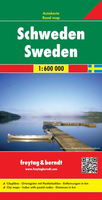
Sweden at 1;600, 000 on a large, double-sided map from Freytag & Berndt, with a separate index booklet listing all localities with their postcodes and providing street plans of central areas in six main cities, including Stockholm and Gothenburg.The country’s topography is shown by bold relief shading, with additional spot heights. National parks and other protected areas are highlighted. Road information includes driving distances on many secondary roads and steep gradients. Car and passenger ferries are marked and railways, rack railways and cable railways are shown. Also indicated are provincial administrative boundaries.Symbols mark various places of interest, including isolated hotels, campsites, etc. Latitude and longitude lines are drawn at 30` intervals. Map legend
includes English.A separate booklet attached to the map cover contains an index and street plans of central Stockholm, Gothenburg/Götebog, Linköping, Sundsvall, Umea and Uppsala.
includes English.A separate booklet attached to the map cover contains an index and street plans of central Stockholm, Gothenburg/Götebog, Linköping, Sundsvall, Umea and Uppsala.

Product Description
Reviews/Comments
Add New
Intelligent Comparison
Archived Product

Sweden ITMB Stanfords
£9.99
Archived Product
Sweden Stanfords
£4.99
Archived Product
Sweden Stanfords
£5.99
Archived Product
Sweden Stanfords
£19.95
Archived Product
Sweden Stanfords
£12.79
Archived Product
Sweden Stanfords
£14.99
Archived Product
Sweden Stanfords
£9.99
Archived Product
Sweden Stanfords
£12.99
Vouchers
No voucher codes found.
Do you know a voucher code for this product or supplier? Add it to Insights for others to use.
Do you know a voucher code for this product or supplier? Add it to Insights for others to use.
 Denmark