
 United Kingdom
 France
 Germany
 Netherlands
 Sweden
 USA
USA
 Italy
Italy
 Spain
Spain
More From Contributor


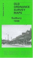
Sudbury 1936
Sudbury in 1936 in a fascinating series of reproductions of old Ordnance Survey plans in the Alan Godfrey Editions, ideal for anyone interested in the history of their neighbourhood or family. The map covers Sudbury, historically part of Harrow parish but now largely in the London Borough of Brent. Coverage stretches from Greenford Road and Sudbury Hill eastward to Llanover Road; and from Blockley Road southward to Drew Gardens. Features include St John`s church, Wembley; North Wembley station, Sudbury station (on LNER, ex GCR line); Sudbury Park, Old Court, Sudbury Park Farm, Sudbury Hall, Swan Inn, tramway, St George`s RC church, Sudbury Priory, St Francis College, St Andrew`s church, a stretch of the Piccadilly Line but with no stations, Sudbury Court, Egremont House
etc. On the reverse are extracts from a street directory, including East Lane, Harrow Road and Sudbury Court Road.About the Alan Godfrey Editions of the 25” OS Series:Selected towns in Great Britain and Ireland are covered by maps showing the extent of urban development in the last decades of the 19th and early 20th century. The plans have been taken from the Ordnance Survey mapping and reprinted at about 15 inches to one mile (1:4, 340). On the reverse most maps have historical notes and many also include extracts from contemporary directories. Most maps cover about one mile (1.6kms) north/south, one and a half miles (2.4kms) across; adjoining sheets can be combined to provide wider coverage.FOR MORE INFORMATION AND A COMPLETE LIST OF ALL AVAILABLE TITLES PLEASE CLICK ON THE SERIES
LINK.

Product Description
Reviews/Comments
Add New
Intelligent Comparison
Archived Product

Sudbury 1902 Stanfords
£3.50
Archived Product
Ledbury 1926 Stanfords
£2.95
Archived Product

Ledbury 1926 Stanfords
£3.50
Archived Product
Sudbury Stanfords
£7.99
Vouchers
No voucher codes found.
Do you know a voucher code for this product or supplier? Add it to Insights for others to use.
Do you know a voucher code for this product or supplier? Add it to Insights for others to use.
 Denmark