
 United Kingdom
 France
 Germany
 Netherlands
 Sweden
 USA
USA
 Italy
Italy
 Spain
Spain
More From Contributor


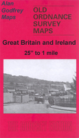
Rushden West 1923
Rushden West in 1923 in a fascinating series of reproductions of old Ordnance Survey plans in the Alan Godfrey Editions, ideal for anyone interested in the history of their neighbourhood or family. Selected towns in Great Britain and Ireland are covered by maps showing the extent of urban development in the last decades of the 19th and early 20th century.In this title: the map covers the western part of Rushden, stretching from the High Street westward to Knuston Hall. Features include railway station, Irchester Road area, boot & shoe factories, leather dressing works, High Street area, Church Green, Rushden Hall, Home Farm, Royal Theatre, etc. On the reverse is a list of private residents from an 1898 directory, with the commercial entry, entries A-C. About the Alan Godfrey
Editions of the 25
Editions of the 25
Product Description
Reviews/Comments
Add New
Intelligent Comparison
Archived Product

Rushden West 1923 Stanfords
£3.50
Archived Product
Rushden East 1923 Stanfords
£2.95
Archived Product

Rushden East 1923 Stanfords
£3.50
Archived Product
Rishton West 1909 Stanfords
£2.95
Archived Product
Rishton West 1909 Stanfords
£3.50
Vouchers
No voucher codes found.
Do you know a voucher code for this product or supplier? Add it to Insights for others to use.
Do you know a voucher code for this product or supplier? Add it to Insights for others to use.
 Denmark