
 United Kingdom
 France
 Germany
 Netherlands
 Sweden
 USA
USA
 Italy
Italy
 Spain
Spain
More From Contributor

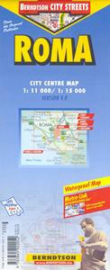
Rome
Rome on a light, waterproof and tear-resistant map from Berndtson, with a plan of the city supplemented by enlargements of its central area, the Forum and the Vatican highlighting 15 top sights, a map of the environs, a transport diagram, and general tourist information.On one side is a more general plan of the city at 1:15, 000, extending north/south from the Olympic Village to EUR complex and Palazzo dello Sport, and from the Vatican to the Campo Verano cemetery in the east. The plan shows the metro network, one way streets, numerous churches and historical sights, main shopping areas, etc.On the reverse an enlargement at 1:11, 000 shows the central part of the city, from the Vatican to the Roma-Termini station and from Piazza del Popolo to the Coliseum in greater detail.
Further enlargements present the Vatican at 1:7, 000, plus the archeological remains of the Foro Romano, also at 1:7, 000, annotated with brief descriptions of main sites. A road map of the city’s environs at 1:250, 000 shows access to the surrounding countryside, including the coast, Castel Gandolfo and Colli Albani. The plans and the road map are indexed with lists of streets/localities plus main sights and places of interest. Also included is a list of the city’s top 15 sights, all highlighted on the plans, a diagram of the metro network, plus information on the city’s climate and general tourist notes.The map is printed on light, waterproof and tear-resistant plastic paper. Map legend includes English. All descriptions and notes are in English only.
Further enlargements present the Vatican at 1:7, 000, plus the archeological remains of the Foro Romano, also at 1:7, 000, annotated with brief descriptions of main sites. A road map of the city’s environs at 1:250, 000 shows access to the surrounding countryside, including the coast, Castel Gandolfo and Colli Albani. The plans and the road map are indexed with lists of streets/localities plus main sights and places of interest. Also included is a list of the city’s top 15 sights, all highlighted on the plans, a diagram of the metro network, plus information on the city’s climate and general tourist notes.The map is printed on light, waterproof and tear-resistant plastic paper. Map legend includes English. All descriptions and notes are in English only.

Product Description
Reviews/Comments
Add New
Intelligent Comparison
Archived Product
Rome Stanfords
£4.99
Archived Product
Rome Stanfords
£7.95
Archived Product
Rome Stanfords
£7.95
Archived Product

Rome Stanfords
£7.99
Archived Product
Rome Stanfords
£3.99
Archived Product
Rome Stanfords
£10.39
Archived Product

Rome Stanfords
£13.99
Archived Product
Rome Stanfords
£12.99
Vouchers
No voucher codes found.
Do you know a voucher code for this product or supplier? Add it to Insights for others to use.
Do you know a voucher code for this product or supplier? Add it to Insights for others to use.
 Denmark