
 United Kingdom
 France
 Germany
 Netherlands
 Sweden
 USA
USA
 Italy
Italy
 Spain
Spain
More From Contributor


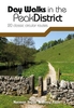


Peak District - Rambler's Guide
Produced in association with the Ramblers, this walking guide covers the popular Peak District and combines detailed route descriptions with information on the local history and wildlife. The Peak District boasts an unrivalled network of around 1, 400 miles of public rights-of-way, and over 80 square miles of open access on the northern moors. This guide allows the reader to explore the infinite variety of walking opportunities, which range from gentle riverside strolls, to tough moorland treks. The introduction gives information about the topography, geology and history of the area, and describes the flora and fauna inhabiting it. The main section of the book comprises 30 walks. Each walk has a key illustrating principal features, such as level of difficulty and type of terrain, a
route profile indicating altitude and distances, and a fact file summarising useful information such as start and finish points, duration, safety advice and points of interest.Illustrated with colour maps from the Ordnance Survey each walk is then described in detail with clear, easy-to-follow instructions. As well as route descriptions, the text gives the history of the main landmarks along the way plus information on the natural history of the area, and is accompanied by stunning colour photographs. Overview map on inside front cover also show start points of the walks. Walks are colour coded to indicate level of difficulty: green for the simpler walks, then amber for moderate walks, then red for the more challenging walks aimed at more experienced walkers. Front cover flap
contains the key to symbols used in the text and on the route maps.
Product Description
Reviews/Comments
Add New
Intelligent Comparison
Archived Product
Lake District - Ramblers Guide Stanfords
£11.99
Archived Product
Peak District Leisure Guide Stanfords
£9.99
Archived Product
Lake District A Dog Walker`s Guide Stanfords
£7.95
Archived Product
Peak District Mini Guide Stanfords
£4.99
Vouchers
No voucher codes found.
Do you know a voucher code for this product or supplier? Add it to Insights for others to use.
Do you know a voucher code for this product or supplier? Add it to Insights for others to use.
 Denmark