
 United Kingdom
 France
 Germany
 Netherlands
 Sweden
 USA
USA
 Italy
Italy
 Spain
Spain
More From Contributor


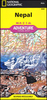


Nepal Himalaya
Nepal on a laminated, waterproof and tear-resistant map from terraQuest, combining coverage of the whole country with more detail mapping for trekking in the Mt. Everest and Annapurna/Dhaulagiri regions, an enlargement of the Kathmandu Valley, plus street plans of Kathmandu and Pokhara. The map consists of a series of panels presenting: The whole of Nepal at 1:1, 100, 000 with relief shading to show its topography. The map shows boundaries of national parks/protected areas and highlights names of main peaks and places of particular interest. Principal trekking routes and locations of base camps are marked. The map has no geographical coordinates. Mount Everest region north of Lukla on an enlargement at 1:115, 000, with trekking routes to the Base Camp, Island Peak and the Gokyo
Lakes. The Annapurna
Lakes. The Annapurna
Product Description
Reviews/Comments
Add New
Intelligent Comparison
Archived Product

Himalaya Stanfords
£8.99
Archived Product
Himalaya Stanfords
£7.95
Vouchers
No voucher codes found.
Do you know a voucher code for this product or supplier? Add it to Insights for others to use.
Do you know a voucher code for this product or supplier? Add it to Insights for others to use.
 Denmark