
 United Kingdom
 France
 Germany
 Netherlands
 Sweden
 USA
USA
 Italy
Italy
 Spain
Spain
More From Contributor

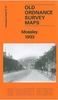


Mossley South 1906
Mossley South in 1906 in a fascinating series of reproductions of old Ordnance Survey plans in the Alan Godfrey Editions, ideal for anyone interested in the history of their neighbourhood or family. Selected towns in Great Britain and Ireland are covered by maps showing the extent of urban development in the last decades of the 19th and early 20th century.In this title: the covers a semi rural area on the east side of Tameside, stretching from Heyrod northward to Mossley Cemetery, and eastward into Cheshire as far as Carrbrook. No major towns are shown and only the southern tip of Mossley but there are several interesting features, including a stretch of the main LNWR line with Scout Tunnel, a stretch of the Stalybridge & Diggle Loop line with Staley & Millbrook station, the
Huddersfield Canal, Spring-grove Mill, St James church, Luzley, Crows i'th' Wood, Scout Mill, Moorgate, Hydegreen, Carr Mill (disused). A directory of Mossley is on the reverse. About the Alan Godfrey Editions of the 25
Huddersfield Canal, Spring-grove Mill, St James church, Luzley, Crows i'th' Wood, Scout Mill, Moorgate, Hydegreen, Carr Mill (disused). A directory of Mossley is on the reverse. About the Alan Godfrey Editions of the 25
Product Description
Reviews/Comments
Add New
Intelligent Comparison
Archived Product

Mossley South 1906 Stanfords
£3.50
Archived Product

Colne South 1910 Stanfords
£3.50
Archived Product

Barnsley South 1904 Stanfords
£3.50
Archived Product

Cradley South 1901 Stanfords
£3.50
Archived Product
Grimsby South 1906 Stanfords
£2.95
Archived Product
Maghull South 1906 Stanfords
£2.95
Archived Product

Grimsby South 1906 Stanfords
£3.50
Archived Product
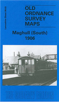
Maghull South 1906 Stanfords
£3.50
Vouchers
No voucher codes found.
Do you know a voucher code for this product or supplier? Add it to Insights for others to use.
Do you know a voucher code for this product or supplier? Add it to Insights for others to use.
 Denmark