More From Contributor

£13.99
Seasoned travel writers Judy Jewell & W. C. Mc Rae share the best ways to experience all that Montana has to offer, from the wilderness of Yellowstone to the rolling prairies of the state`s eastern region. Jewell & Mc Rae lead travellers to the highlights of the Big Sky Country with trip ideas such as A Lewis & Clark Expedition & Fishing Southwest Montana. Complete with tips for cross-country skiing at Glacier National Park, observing elk at Charles M. Russell National Wildlife Refuge, & finding the best watering holes in Missoula, Moon Montana gives travellers the tools they need to create a more personal & memorable experience. This full-colour guide

Includes::
colour photos & helpful maps.

...
Archived Product
£11.99
Montana is a state that many Americans know very little about, but its criminal

Dimensions can sometimes run as deep

...
Archived Product
£19.95
Montana Recreational Atlas & Gazetteer at 1:250, 000 in a series of large format paperback state atlases from De Lorme, with detailed, contoured, GPS compatible topographic mapping plus extensive recreational information, with lists of sites & facilities, etc. Each title covers one state & presents it on impressively detailed mapping at scales much more detailed than used on most state road maps. Particularly popular areas are often also presented on enlargements. The maps are contoured, show variation of terrain (deserts, glaciers, wetlands, woodlands, etc) & have latitude & longitude and/or UTM grid lines for GPS use. Various types of protected areas are distinguished by the colouring of their boundaries, e.g. national or state parks, forests, etc. Also marked are Indian Reservations & restricted entry military zones. Road network is shown in much more detail than on other state mapping, with local roads, unsurfaced back roads & tracks, forest trails, etc. Where appropriate, old historical routes are marked. Railway lines & local airports or landing strips are included & the maps also indicate administrative boundaries. Symbols highlight various recreational areas & facilities such as campgrounds, unique natural features, etc. Each title contains extensive lists of outdoor adventure sites (grouped into activities such as hiking, biking, paddling, fishing, skiing, etc.), diverse family outing sites, campgrounds, & tables showing what facilities can be found in the state ...
Archived Product
£24.99
Montana Recreational Atlas & Gazetteer at 1:250, 000 in a series of large format paperback state atlases from De Lorme, with detailed, contoured, GPS compatible topographic mapping. Glacier National Park is shown on more detailed maps at 1:125, 000 with an overprint highlighting numerous trails & various facilities. The atlas also

Includes::
a map of the state showing publicly owned lands. Recreational information

Includes::
a special section for the Glacier NP, plus state-wide lists of unique natural features, historic museums & sites, Indian lands, hiking trails, plus extensive detailed information on fishing & hunting. Tables are also provided listing national/state/BLM lands & campgrounds indicating facilities. Each title in this De Lorme series covers one state & presents it at a scale much more detailed than used on most state road maps. Particularly popular areas are often also presented on enlargements. The maps are contoured, show variation of terrain (deserts, glaciers, wetlands, woodlands, etc) & have latitude & longitude and/or UTM grid lines for GPS use. Various types of protected areas are distinguished by the colouring of their boundaries, e.g. national or state parks, forests, etc. Also marked are Indian Reservations & restricted entry military zones. Road network is shown in much more detail than on other state mapping, with local roads, unsurfaced back roads & tracks, forest trails, etc. Where appropriate, old historical routes are marked. Railway lines & local airports or landing strips are included & the maps also indicate administrative boundaries. Symbols highlight various recreational areas & facilities such as campgrounds, unique natural features, etc. Each title contains extensive lists of outdoor adventure sites (grouped into activities such as hiking, biking, paddling, fishing, skiing, etc.), diverse family outing sites, campgrounds, & tables showing what facilities can be found in the state’s recreational areas. Each atlas also has an index of localities. To see the list of titles in this series please click on the series link.


...
Archived Product
£22.95
Montana at 1:250, 000 in a series of excellent, detailed, GPS compatible state atlases from Benchmark Maps with extensive information on diverse recreational opportunities & facilities, covering The Rockies & the western states of the United States. Each atlas consists of three main sections: Landscape: with detailed mapping at scales around 1:250, 000, according to the size of the state. Excellent use of relief shading & altitude colouring provides a vivid picture of the topography, with plenty of names of physical features such a mountain & hill ranges, peaks, valleys, etc. All heights are given in feet. Boundaries of national parks, state forests, Indian reservations & military areas are marked. The presentation of the road network

Includes::
finely graded paved roads, 4WD tracks & other unclassified roads (rough 4WD tracks, logging & private roads, etc). Symbols highlight various recreational facilities. The maps are fully GPS compatible, with a latitude & longitude grid at 10

...
Archived Product
£12.99
Montana, map No. 273, in the standard topographic survey of Switzerland at 1:50, 000 from Swisstopo, i.e. without the special overprint highlighting walking trails, local bus stops, etc, presented in Swisstopo’s hiking editions of the 50K survey. The map is divided by the Rhone Valley with Sierre & Sion & covers north of it the resorts of Crans-Montana & Lans & the peak of Wildhorn, & to the south most of Val d’ Anniviers & the lower part of Val d’ Herens. Highly regarded for their superb use of graphic relief & hill shading, the maps give an almost 3-D picture of Switzerland`s mountainous terrain. Contours are at 20m intervals. All the maps have a 1-km grid with the Swiss national coordinates. This standard version of the 50K survey covers the whole country on 78 small format sheets, with special larger format maps published for several popular tourist destinations. Small format sheets cover an area of 35 x 24 km (21 x 15 miles approx) & have map legend in the language of the area covered by the map. The special larger sheets cover 50 x 35 km (31 x 22 miles approx) & have no map legend, but a separate leaflet can be provided instead.PLEASE NOTE: the hiking editions of the 1:50, 000 Swisstopo survey are listed on our website in a separate series. ...
Archived Product
£18.99
Montana area, map No. 273T, at 1:50, 000 in a special hiking edition of the country’s topographic survey, published by Swisstopo in cooperation with the Swiss Hiking Federation. The map is divided by the Rhone Valley with Sierre & Sion & covers north of it the resorts of Crans-Montana & Lens & the peak of Wildhorn, & to the south most of Val d’ Anniviers & the lower part of Val d’ Herens. Cartography, identical to the standard version of the survey, is highly regarded for its superb use of graphic relief & hill shading to provide an almost 3-D picture of Switzerland`s mountainous terrain. Contours are at 20m intervals. An overprint highlights routes maintained by the SHF, distinguishing between hiking routes, mountain routes requiring proper footwear, & alpine routes where equipment is needed. Paths which are part of the national or regional network of long-distance hiking routes are specially marked & in the more recent editions are annotated with their official numbers. The maps show mountain huts, refuges & in remote areas also inns, plus roads with bus service & the positions of bus stops. All the maps have a 1-km grid of the Swiss national coordinates. For a list of all the titles in this series, please click on the series link. ...
Archived Product
£22.99
Detailed ski map at 1:50, 000 from Swisstopo, the country’s national survey organization, showing routes for skiing and/or snowboarding, access by public transport, recommended itineraries, lists of mountain huts, etc. The series uses the cartography of Switzerland’s topographic survey, with additional colouring to show slopes steeper than 30°. An overprint highlights ski routes, indicating suggested direction, difficult passages & sections which must be covered on foot. Also marked are areas where it is forbidden to leave the routes shown on the map. The maps also highlight roads with bus routes, indicating individual bus stops, show ski lifts & funiculars, plus mark locations of refuges or other mountain accommodation. Each title has the Swiss national grid at intervals of 1km, plus latitude & longitude margin ticks at 1’. Some titles cover a larger area, with a part of an adjoining sheet printed on the reverse of the main map as indicated on our series grid. Where appropriate, ski information extends across the border to France & Italy. On the reverse are itineraries of routes recommended by the Swiss Alpine Club, indicating the degree of difficulty, plus lists of alpine huts with contact details. Map legend for the overprint

Includes::
English. The text about the routes & accommodation is in the main language of the area covered by the map. To see the list of all the titles in this series please click on the series link.

...
Archived Product
£6.99
Western Montana Recreational Map at approx. 1:790, 000 from GTR Mapping in a series covering the Rocky Mountains states of USA on indexed, topographic recreational maps designed to provide good presentation of each state’s geography, protected areas, recreational facilities & places of interest, plus on the reverse additional tourist information. Coverage extends south-east into Wyoming to include the whole of the Yellowstone National Park. Topography is presented by contours at 1000 feet intervals, enhanced by changes in altitude colouring every 2000’, plus plenty of names of mountain ranges, peaks, etc. The network of rivers, lakes & reservoirs is shown in great detail, with numerous small rivers & creeks named & on some titles state fishing access sites are marked. National or state parks, recreational areas, forests, grassl&, wildlife refuges, etc, are highlighted, as well as Indian Reservations & restricted access military bases. Road network distinguishes between gravel & dirt surface local roads & indicates routes more suitable for 4WD vehicles. Driving distances are marked on main routes. Symbols indicate five different kinds of campgrounds. Also marked are picnic grounds & rest areas, skiing areas, & various other places of interest. A special feature of this series is the inclusion of symbols indicating mining districts with old mining and/or ghost towns. Each title is indexed &, unless specified to the contrary in its individual description, has no geographical coordinates. The reverse side of each map provides extensive tourist information with lists of national parks & other protected areas indicating what facilities can be found there, county by county lists of both various historical & cultural places of interest & protected areas, lists of mining districts, etc. Also provided is a climate & mileage chart for each state. ...
Archived Product
£6.95
Topographic coverage of mainland Spain at 1:50, 000 in the MTN50 (Mapa Topográfico Nacional) series from the Centro Nacional de Información Geografica, the country’s civilian survey organization. The maps have contours at 20m intervals, enhanced by relief shading, plus colouring and/or graphics to show different types of terrain, vegetation or land use. Boundaries of national parks & other protected areas are marked. In addition to all the usual information featured on topographic mapping at this scale, detailed presentation of the road & rail networks, rural tracks & paths, etc, the maps also show campsites & mountain refuges. On more recent editions some GRs, the official long-distance hiking routes, are also marked (although not as clearly as on hiking maps from other publishers). Each map covers 29.5x 18.5 km (with adjustments in the border or coastal areas). The maps have a 1-km UTM grid, plus margin ticks for latitude & longitude at 1` intervals. Map legend is in Spanish only.HOW TO CHOOSE THE RIGHT 50K MAP: all the titles in CNIG’s 200K Provincial Road Maps series at 1:200, 000 are overprinted with the grid for the 1:50, 000 maps & can be used to see the area covered by each 50K title. TO SEE THE LIST OF TITLES IN THIS SERIES PLEASE CLICK ON THE SERIES LINK.PLEASE NOTE
- MAP TITLES: the grids shown on our website serve both the civilian & the military 1:50, 000 topographic series. Although the areas covered by maps in both series are identical (apart from some border or coastal sheets), occasionally map titles differ – only one title is shown on the grid, usually the military one. In Galicia, the Basque country & in the Catalan speaking areas the tendency now is to use local place names rather than the often better known Castilian ones. Where possible, both versions are included in our titles. Map titles listed on our website are based on information received by us at the time of publication, but sometimes maps arrive showing a completely different title! As long as the map number is as ordered, the correct map has been supplied.
...
Archived Product

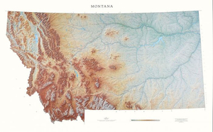
Montana State Physical Wall Map

Detailed physical wall map of Montana State at a scale of 1:600, 000. The cartography shows relief through a stunning, highly detailed shading, with different elevations varing in colouring, giving an almost 3-dimensional feel to the map. Peak heights are also clearly marked.The map displays land only within the boundaries of the chosen states - there is no overlap with neigbouring states. Principal physical features such as glaciers, mountain ranges, rivers and lakes are shown clearly. Human features, such as main towns, cities, roads and railways, are shown in a very fine, subtle and elegant cartographic style. State capitals are also clearly marked.This map measures 105x163cm (41”x64”). The Big Sky state has two distinct geographic regions. In the west are the Rocky
Mountains, with over 50 named mountain ranges and Flathead Lake. In the east are the Great Plains and Fort Peck Reservoir. The exquisite Missouri and Yellowstone Rivers run through both regions.*About this series:*Located on the corner of Main and Central in downtown Medford, Oregon since 1986, Raven has become the quintessential small company with a big reputation. Every map is created with attention to accuracy and elegance, from gathering the base information to the final color adjustment on the printing press.
RIP - This product is no longer available on our network. It was last seen on 25.09.2019

This page now acts as a permanent archive for this product. Add more information using the comments box below to ensure it can still be found by future generations.

Use our search facility to see if it is available from an alternative contributor.
  • External links may include paid for promotion
  • Availability: Out Of Stock
  • Supplier: Stanfords
  • SKU: 9780783425740
Availability: In Stock
£30.00

Product Description

Detailed physical wall map of Montana State at a scale of 1:600, 000. The cartography shows relief through a stunning, highly detailed shading, with different elevations varing in colouring, giving an almost 3-dimensional feel to the map. Peak heights are also clearly marked. The map displays land only within the boundaries of the chosen states
- there is no overlap with neigbouring states. Principal physical features such as glaciers, mountain ranges, rivers & lakes are shown clearly. Human features, such as main towns, cities, roads & railways, are shown in a very fine, subtle & elegant cartographic style. State capitals are also clearly marked. This map measures 105x 163cm (41”x 64”). The Big Sky state has two distinct geographic regions. In the west are the Rocky Mountains, with over 50 named mountain ranges & Flathead Lake. In the east are the Great Plains & Fort Peck Reservoir. The exquisite Missouri & Yellowstone Rivers run through both regions.* About this series:* Located on the corner of Main & Central in downtown Medford, Oregon since 1986, Raven has become the quintessential small company with a big reputation. Every map is created with attention to accuracy & elegance, from gathering the base information to the final color adjustment on the printing press.

Reviews/Comments

Add New

Price History

Vouchers

No voucher codes found.
Do you know a voucher code for this product or supplier? Add it to Insights for others to use.

Facebook

Jargon Buster

Physical - Used to describe strength or visual properties of an item
Wall - A physical barrier between two areas
Human - A highly developed and adapted mamal and deminant species on earth
Railways - A set of tracks that have been laid for the purpose of trains to travel up and down them
Small - something that takes up less space than normal.
Distinct - Something that can be seen to be slightly different.
Subtle - Something that is delicate and not to harsh, can be difficult to describe.

Supplier Information

Stanfords
Stanfords was established in 1853 and opened their iconic Covent Garden flagship store in 1901. They have become the top retailer of maps, travel books and accessories in the UK and arguably offer the largest selection of maps and travel books worldwide. Famous names such as Captain Robert Falcon Scott, Ranulph Fiennes and Michael Palin have purchased from Stanfords. They now have a shop in Bristol and both stores together with other venues operate a calendar of events including talks, book signings and exhibitions. As a specialist map retailer, the map selection is comprehensive and includes road maps, street maps and walking maps from worldwide destinations, as well as a selection of world atlases and wall maps. Books include travel guides and travel literature. Stanfords also stock globes, from miniatures made of blue marble to magnificent floor-standing globes. The website features a selection of interesting articles on travel topics.
Page Updated: 2023-11-12 20:15:36

Community Generated Product Tags

Oh No! The productWIKI community hasn't generated any tags for this product yet!
Menu