More From Contributor

£17.95

Includes: inset of St Croix (1:100, 000) Other plans included: Christiansted (St Croix) Port Alucroix & Limetree Bay
...
Archived Product
£12.99
Vienna in the Blue Guides series focuses primarily on cultural tourism for the visitor who wishes to understand more of what they might see &, as such, the title provides thorough & objective reference information covering art, history & architecture. The guide features illustrations aimed to inform rather than just decorate, such as maps, diagrams, floor plans, architectural details & photographs. Cross referenced indexing means information is accessible & layout navigable. Selective listings of restaurants & accommodation are chosen in the belief that good, practical recommendations will contribute to the enjoyment of good art & culture. ...
Archived Product
£5.99
Valencia Region & Murcia at 1:400, 000 in a series of indexed touring maps of Spain from Michelin. The map provides a good presentation of the landscape, highlighting scenic routes & national/regional parks, &

Includes::
street plans of Valencia, Alicante & Murcia showing principal sights & facilities, main traffic routes, one way street & pedestrianized areas; each plan has a short index listing main streets. The map also indicates locations with a street plan in the Michelin`s Red Guide to hotels & restaurants in Spain & Portugal &

Includes::
a distance/driving times table for the two regions. Maps in the Michelin’s regional series of Spain have topography indicated by bold relief shading with spot heights & colouring for forested areas. Detailed road information, characteristic of Michelin’s maps,

Includes::
toll & free sections of motorways, road widths, difficult or dangerous roads, restrictions & seasonal closures, steep gradients, level crossings & fords, etc. Railway lines are shown with stations & car ferry routes indicate maximum tonnage. Tourist information

Includes::
paradors & selected campsites, places of interest, scenic routes & viewpoints, sport & leisure facilities, etc. The maps also indicate locations with a street plan in the Michelin`s Red Guide to hotels & restaurants in Spain & Portugal. The maps have a grid showing latitude & longitude at intervals of 20’. The index of place name is next to the map. Each title also has street plans of main towns, as indicated in the individual descriptions, & a distance/driving time table. Map legend

Includes::
English.


...
Archived Product
£17.99
Street atlas covering Vienna plus the main population centres around the city, including Wiener Neustadt. Bus & tram lines are very clearly marked, but one way streets are not shown. Additional maps show the environs of the city, major traffic arteries & metro, suburban & regional rail networks. The city centre is also covered at a more detailed scale of 1:12, 500. A separate map highlights Vienna`s fourteen main momuments, with brief descriptions in English. The index contains lists of useful addresses. Map legend

Includes::
English.

...
Archived Product
£9.95
Topographic survey of Portugal at 1:50, 000 from the Instituto Geográfico do Exército, the country’s military survey organisation. The maps have contours at 20m intervals & in addition to the standard features shown on topographic mapping at this scale also indicate various types of terrain or vegetation (s&, terraces, rocks, woodlands, vineyards, etc). Each sheet covers an area of 32 x 20km (20 x 12.5 miles approx). The maps have a 1-km UTM grid plus latitude & longitude coordinates for the map corners. Map legend & a glossary of terms used on the maps include English.EDITION DATES: most titles in this series date from 1990s or later. To see all the titles in this series please click on the series link. ...
Archived Product
£13.99
Lonely Planet Vancouver is your passport to all the most relevant & up-to-date advice on what to see, what to skip, & what hidden discoveries await you. Stretch out on a beach along Stanley Park`s Seawall, experience an authentic dim sum lunch, or hop a tiny tugboat to Granville Island Public Market; all with your trusted travel companion. Get to the heart of Vancouver & begin your journey now! Inside Lonely Planet`s Vancouver Travel Guide: Full-color maps & images throughout. Highlights & itineraries show you the simplest way to tailor your trip to your own personal needs & interests. Insider tips save you time & money, & help you get around like a local, avoiding crowds & trouble spots. Essential info at your fingertips
- including hours of operation, phone numbers, websites, transit tips, & prices. Honest reviews for all budgets
- including eating, sleeping, sight-seeing, going out, shopping, & hidden gems that most guidebooks miss. Cultural insights give you a richer & more rewarding travel experience
- including Native culture, multicultural festivals & cuisine, history, wildlife, outdoor activities & the arts. Free, convenient pull-out Vancouver map (included in print version), plus over 40 color maps. Useful features
- including Travel with Children, Day Trips & Month by Month (annual festival calendar). Coverage of the West End, Gastown, Chinatown, Granville Isl&, Whistler, Victoria, the Southern Gulf Islands, & more. The Perfect Choice: Lonely Planet Vancouver, our most comprehensive guide to Vancouver, is perfect for those planning to both explore the top sights & take the road less traveled. Looking for just the highlights of Vancouver? Check out Lonely Planet`s Discover Canada, a photo-rich guide to the city`s most popular attractions. Looking for more extensive coverage? Check out Lonely Planet`s British Columbia & the Rockies guide for a comprehensive look at all the region has to offer, or Lonely Planet`s Discover Canada, a photo-rich guide to the country`s most popular attractions. Authors: Written & researched by Lonely Planet & John Lee. About Lonely Planet: Started in 1973, Lonely Planet has become the world`s leading travel guide publisher with guidebooks to every destination on the planet, as well as an award-winning website, a suite of mobile & digital travel products, & a dedicated traveler community. Lonely Planet`s mission is to enable curious travelers to experience the world & to truly get to the heart of the places they find themselves in. Trip Advisor Travelers` Choice Awards 2012 & 2013 winner in Favorite Travel Guide category ` Lonely Planet guides are, quite simply, like no other.`
- New York Times ` Lonely Planet. It`s on everyone`s bookshelves; it`s in every traveller`s hands. It`s on mobile phones. It`s on the Internet. It`s everywhere, & it`s telling entire generations of people how to travel the world.`
- Fairfax Media (Australia).


...
Archived Product
£9.99
The Rough Guide to Vintage London is your ultimate guide to London`s burgeoning vintage scene, that is making the British capital a more exciting place to visit than ever before. Whether you`re into fifties fashion or seventies furnishings, old-fashioned beauty parlours, Art Deco cafes or retro restaurants, The Rough Guide to Vintage London will show you where to find the best bargains & the hippest hang-outs. This authoritative illustrated guide casts a discerning eye over the entire city, highlighting the best of vintage London in each area. It covers over 200 budget & luxury attractions, from the East End hotspots of hyper-cool Hoxton & Shoreditch to the eccentric emporia of the West End, as well as the pick of London`s markets & the classiest vintage outlets north & south of the centre, all marked on full-colour maps. Whatever your look or interest
- blitz chic, beehive hairdo, forties screen idol, rockabilly, twenties flapper or Edwardian chap
- The Rough Guide to Vintage London will tell you where you can enjoy them to the full.

...
Archived Product
£14.99
These beautiful postcards have been selected from the bestselling V&A Pattern titles. Drawing on designs intended for textiles, wallpaper, fashion & furnishing, this richly varied collection is a resource for artists, designers & students, as well as a charming addition to the design fan`s stationery collection. Presented in a colourful presentation box, these beautifully printed patterns range from the intricate floral motifs of William Morris & C.F.A. Voysey to the wit & vibrancy of Pop era design; from the cool restraint of Fifties textile design to the iconic designs of Liberty & Co. A desirable gift & a surprising trove of design inspiration, this postcard collection is the perfect introduction to the V&A`s design collections. ...
Archived Product
£30.00
This attractive series reveals the V&A`s spectacular & extensive pattern collections. Each title in the series

Includes::


...
Archived Product
£3.99
Discover V-Mail
- the Roman empire's equivalent of the email or text message! The letters discovered at Vindolanda were written
...
Archived Product

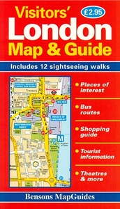
London Visitors` Map And Guide

London Visitors` Map and Guide from Bensons MapGuides in their range of street plans of central London, highlighting 12 recommended sightseeing routes, with an enlargement of the West End and the City, a bus map, descriptions of places of interest.On one side is the main map with the publishers’ standard cartography presented at 1:11, 800 approx. Coverage extends, roughly, from Earl’s Court to The Tower and north/south from London Zoo and St Pancras International Eurostar terminal to the southern bank of the Thames between the Vauxhall and the Tower bridges, including the Imperial War Museum. On the reverse the West End and the City (Park Lane to The Tower and north/south British Museum to the southern bank of the Thames from Lambeth Bridge to Tower Bridge) is presented on more
detailed mapping. A separate panel covers central Greenwich. The plans have an overprint highlighting in all 12 recommended sightseeing routes, cross-referenced to the surrounding panels with descriptions of the sights.Also provided are indexes of selected main streets, plus of places of interest, entertainment venues and hotels, a map of bus routes, a list of key dates in London’s history, plus general tourist information and a diagram of the Underground network. Current edition of this title was published in 2011.About Bensons range of street plans of central London:The plans offer the clearest, most accurate and most informative street mapping of the capital, particularly for those who wish to explore London on foot. The same style of presentation of the street network is used
in different titles with varying degree of detail. Excellent placing of names and the use of colours or symbols enable the publishers to provide a wealth of information whilst retaining the clarity of small detail: streets with bus services, Underground/railway stations and riverboat piers, prime shopping areas, places of entertainment and main services, selected hotels and pubs, etc. The capital’s main sights are prominently highlighted and other important buildings are named. For drivers the maps indicate main traffic routes and show entry restrictions for motorized traffic and car parks. One way streets are not marked.For those exploring London on foot the Bensons plans offer information not often found on other street maps: small passages, steps or stairways, foot access onto
bridges from streets below them, etc.Additional panels, varying from title to title, provide more information: enlargements of the West End and the City, bus routes, places of entertainment, descriptions of sights, sightseeing walks, a shopping guide, etc.For more information please see the individual description. The most detailed coverage is offered by the London Street Map.
RIP - This product is no longer available on our network. It was last seen on 25.09.2019

This page now acts as a permanent archive for this product. Add more information using the comments box below to ensure it can still be found by future generations.

Use our search facility to see if it is available from an alternative contributor.
  • External links may include paid for promotion
  • Availability: Out Of Stock
  • Supplier: Stanfords
  • SKU: 9781898929338
Availability: In Stock
£2.95

Product Description

London Visitors` Map & Guide from Bensons Map Guides in their range of street plans of central London, highlighting 12 recommended sightseeing routes, with an enlargement of the West End & the City, a bus map, descriptions of places of interest. On one side is the main map with the publishers’ standard cartography presented at 1:11, 800 approx. Coverage extends, roughly, from Earl’s Court to The Tower & north/south from London Zoo & St Pancras International Eurostar terminal to the southern bank of the Thames between the Vauxhall & the Tower bridges, including the Imperial War Museum. On the reverse the West End & the City (Park Lane to The Tower & north/south British Museum to the southern bank of the Thames from Lambeth Bridge to Tower Bridge) is presented on more detailed mapping. A separate panel covers central Greenwich. The plans have an overprint highlighting in all 12 recommended sightseeing routes, cross-referenced to the surrounding panels with descriptions of the sights. Also provided are indexes of selected main streets, plus of places of interest, entertainment venues & hotels, a map of bus routes, a list of key dates in London’s history, plus general tourist information & a diagram of the Underground network. Current edition of this title was published in 2011. About Bensons range of street plans of central London: The plans offer the clearest, most accurate & most informative street mapping of the capital, particularly for those who wish to explore London on foot. The same style of presentation of the street network is used in different titles with varying degree of detail. Excellent placing of names & the use of colours or symbols enable the publishers to provide a wealth of information whilst retaining the clarity of small detail: streets with bus services, Underground/railway stations & riverboat piers, prime shopping areas, places of entertainment & main services, selected hotels & pubs, etc. The capital’s main sights are prominently highlighted & other important buildings are named. For drivers the maps indicate main traffic routes & show entry restrictions for motorized traffic & car parks. One way streets are not marked. For those exploring London on foot the Bensons plans offer information not often found on other street maps: small passages, steps or stairways, foot access onto bridges from streets below them, etc. Additional panels, varying from title to title, provide more information: enlargements of the West End & the City, bus routes, places of entertainment, descriptions of sights, sightseeing walks, a shopping guide, etc. For more information please see the individual description. The most detailed coverage is offered by the London Street Map.

Reviews/Comments

Add New

Price History

Vouchers

No voucher codes found.
Do you know a voucher code for this product or supplier? Add it to Insights for others to use.

Facebook

Jargon Buster

Foot - A part of the body at the bottom end of the leg
Foot - or Feet - a measurement equivilent to 30cm
Key - A physical or virtual device or code used for opening something
History - Anything that happens in the past. An acedemic subject.
Entertainment - Something that provides amusement
Car - A machine used for transport which runs on roads
Network - A link and communication between things. Often computers or people.
Small - something that takes up less space than normal.
Vauxhall - A british car company, known as OPEL in europe. Vauxhall is owned by General Motors (GM) who are an American based multinational car corporation.

Vauxhall has a wide range of cars covering all market sectors including:
Ampera
Antara
Astra
Corsa
Insignia

Vauxhall also produces a range of commercial vehicles including the Combo Van which is popular with the Royal Mail and the Vivaro and Movano.
Accurate - A measurement of precision when all elements are correct.
Greenwich - A southern borough in London.
Degree - An angle measurement, also can be the measurement of an extent that something happens, can also relate to an university academic measurement.
degree - The extremity of something or the angle. Can also relate to a university achievement.
Museum - A building which exhibits old artefacts for viewing of people who show interest.
Individual - A single separate item or person.

Supplier Information

Stanfords
Stanfords was established in 1853 and opened their iconic Covent Garden flagship store in 1901. They have become the top retailer of maps, travel books and accessories in the UK and arguably offer the largest selection of maps and travel books worldwide. Famous names such as Captain Robert Falcon Scott, Ranulph Fiennes and Michael Palin have purchased from Stanfords. They now have a shop in Bristol and both stores together with other venues operate a calendar of events including talks, book signings and exhibitions. As a specialist map retailer, the map selection is comprehensive and includes road maps, street maps and walking maps from worldwide destinations, as well as a selection of world atlases and wall maps. Books include travel guides and travel literature. Stanfords also stock globes, from miniatures made of blue marble to magnificent floor-standing globes. The website features a selection of interesting articles on travel topics.
Page Updated: 2023-11-12 20:15:36

Community Generated Product Tags

Oh No! The productWIKI community hasn't generated any tags for this product yet!
Menu