
 United Kingdom
 France
 Germany
 Netherlands
 Sweden
 USA
USA
 Italy
Italy
 Spain
Spain
More From Contributor


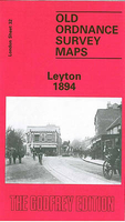
Leyton 1894
Leyton in 1894 in a fascinating series of reproductions of old Ordnance Survey plans in the Alan Godfrey Editions, ideal for anyone interested in the history of their neighbourhood or family. Three versions cover the same area, from Templemill Sidings eastward to Woodhouse Road and Newcomen Road, and from Carlisle Road and St Mary`s church southward to Crownfield Road. St Patricks RC cemetery is in the centre of the map and other features include the massive West Ham Union Workhouse opened in 1840, GER wagonworks, Leyton Isolation Hospital, Ruckholt Farm, tramways and tram works, GER Epping line with Leyton station, Tottenham & Forest Gate line with Leytonstone station, Harrow Green, Holy Trinity church. The principal roads running north-south through the map are Leyton Road and
High Road. Leyton itself is to the top of the map, while in the south-eastern corner is Wanstead Slip, with Jews Cemetery. The area saw enormous changes over the years. The first map shows an almost entirely rural village, with development only just begun and Leyton station standing among fields; by 1914 the area was largely built on. The population of Leyton in 1861 was just 4, 794; by 1921 it had risen to 128, 430. About the Alan Godfrey Editions of the 25” OS Series:Selected towns in Great Britain and Ireland are covered by maps showing the extent of urban development in the last decades of the 19th and early 20th century. The plans have been taken from the Ordnance Survey mapping and reprinted at about 15 inches to one mile (1:4, 340). On the reverse most maps have historical
notes and many also include extracts from contemporary directories. Most maps cover about one mile (1.6kms) north/south, one and a half miles (2.4kms) across; adjoining sheets can be combined to provide wider coverage.FOR MORE INFORMATION AND A COMPLETE LIST OF ALL AVAILABLE TITLES PLEASE CLICK ON THE SERIES LINK.

Product Description
Reviews/Comments
Add New
Intelligent Comparison
Archived Product

Leyton 1914 Stanfords
£3.50
Archived Product

Merton 1894 Stanfords
£3.50
Archived Product

Heston 1894 Stanfords
£3.50
Archived Product
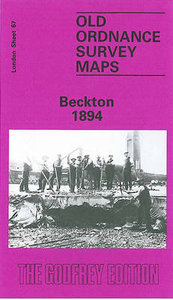
Beckton 1894 Stanfords
£3.50
Archived Product
Leytonstone 1893 Stanfords
£3.50
Vouchers
No voucher codes found.
Do you know a voucher code for this product or supplier? Add it to Insights for others to use.
Do you know a voucher code for this product or supplier? Add it to Insights for others to use.
 Denmark