More From Contributor

£5.99
Simon Webb’s Pocket Miscellany of facts about Kingston-upon-Thames explores both the modern life of this London borough, as well as its historical background. For over a century, Kingston-upon-Thames was the de facto capital of Engl&. This Royal borough & Surrey market town situated on the banks of the River Thames was the coronation site of seven Saxon kings & during the reign of Henry VIII its renowned Hampton Court Palace featured bowling alleys, tennis courts & a 36, 000 sq ft kitchen. Nowadays a renowned centre for retail & the arts, Kingston boasts green spaces, cafe culture & architecture. This engaging little book explores both the modern life of this most vibrant & exciting of London boroughs, as well as exploring its historical background. ...
Archived Product
£3.50
Kingswinford in 1901 in a fascinating series of reproductions of old Ordnance Survey plans in the Alan Godfrey Editions, ideal for anyone interested in the history of their neighbourhood or family. The map covers much of Kingswinford, to the west of the Black Country, extending southward to Mount Pleasant. Features include Stourbridge Workhouse, tramways, Halfway, Summer Hill, Summerhill House, Bradley Hall, etc. On the reverse is a 1912 directory of Kingswinford. About the Alan Godfrey Editions of the 25” OS Series: Selected towns in Great Britain & Ireland are covered by maps showing the extent of urban development in the last decades of the 19th & early 20th century. The plans have been taken from the Ordnance Survey mapping & reprinted at about 15 inches to one mile (1:4, 340). On the reverse most maps have historical notes & many also include extracts from contemporary directories. Most maps cover about one mile (1.6kms) north/south, one & a half miles (2.4kms) across; adjoining sheets can be combined to provide wider coverage.FOR MORE INFORMATION & A COMPLETE LIST OF ALL AVAILABLE TITLES PLEASE CLICK ON THE SERIES LINK. ...
Archived Product
£3.50
Kington in 1927 in a fascinating series of reproductions of old Ordnance Survey plans in the Alan Godfrey Editions, ideal for anyone interested in the history of their neighbourhood or family. The map shows the town in the top half, with the more rural area to the bottom. The northern part the map features the railway line & station, Waterloo Bridge, Gravel Hill, St Mary`s Church, Lady Hawkins Grammar School & Victoria Cottage Hospital; the southern half

Includes::
the Poor Law Institution, Penrhos Wood & Mortuary Chapel & Cemetery. On the reverse is a list of private residents & a commercial directory. About the Alan Godfrey Editions of the 25” OS Series: Selected towns in Great Britain & Ireland are covered by maps showing the extent of urban development in the last decades of the 19th & early 20th century. The plans have been taken from the Ordnance Survey mapping & reprinted at about 15 inches to one mile (1:4, 340). On the reverse most maps have historical notes & many also include extracts from contemporary directories. Most maps cover about one mile (1.6kms) north/south, one & a half miles (2.4kms) across; adjoining sheets can be combined to provide wider coverage.FOR MORE INFORMATION & A COMPLETE LIST OF ALL AVAILABLE TITLES PLEASE CLICK ON THE SERIES LINK.

...
Archived Product
£14.99
Waterproof & tear-resistant OS Active version of map No. 35 from the Ordnance Survey’s Landranger series at 1:50, 000, with contoured & GPS compatible topographic mapping plus tourist information.MOBILE DOWNLOADS: As well as the physical edition of the map, each Landranger title now

Includes::
a code for downloading after purchase its digital version onto your smartphone or tablet for viewing on the OS smartphone app.OS LANDRANGER SERIES: to see the list of all the titles in the OS Landranger series, both paper & waterproof versions, please click on the series link. Maps in the Landranger series provide plenty of recreational & tourist information, indicating the traditional public right of way paths (except in Scotland where different laws apply), including bridleways & byways restricted or open to motorized traffic. National Trails & selected other long-distance paths are marked, as well as on-road & traffic-free cycle routes with their National/ Regional Cycle Network numbers. National Trust/ National Trust for Scotland & Forestry Commission land is clearly marked, indicating open or restricted access. A range of symbols highlights camping & caravanning sites, youth hostels, tourist information offices & visitors’ centres, parking & picnicking places, World Heritage sites, sport & recreational facilities, etc. The maps provide detailed presentation of topography with contours at 10m intervals, numerous spot heights & additional colouring and/or graphics for different types of woodlands, orchards or parkl&, rock features including scree & cliffs, water features inland & along the sea shore with marshl&, dunes, s&, mud, shingle & the high water mark. All the standard information expected of survey mapping at this scale is included: finely graded road network, railway lines with stations, cuttings, embankments, etc; individual isolated buildings; archaeological & historical sites, etc. For GPS users the British National Grid is shown at 1km intervals, with latitude & longitude given by margin ticks at 1` & cross hairs on the map at 5`. Each map covers an area of 40 x 40km, (approx. 25 x 25 miles).

...
Archived Product
£8.99
Paper version of map No. 35 from the Ordnance Survey’s Landranger series at 1:50, 000, with contoured & GPS compatible topographic mapping plus tourist information.MOBILE DOWNLOADS: As well as the physical edition of the map, each Landranger title now

Includes::
a code for downloading after purchase its digital version onto your smartphone or tablet for viewing on the OS smartphone app.OS LANDRANGER SERIES: to see the list of all the titles in the OS Landranger series, both paper & waterproof versions, please click on the series link. Maps in the Landranger series provide plenty of recreational & tourist information, indicating the traditional public right of way paths (except in Scotland where different laws apply), including bridleways & byways restricted or open to motorized traffic. National Trails & selected other long-distance paths are marked, as well as on-road & traffic-free cycle routes with their National/ Regional Cycle Network numbers. National Trust/ National Trust for Scotland & Forestry Commission land is clearly marked, indicating open or restricted access. A range of symbols highlights camping & caravanning sites, youth hostels, tourist information offices & visitors’ centres, parking & picnicking places, World Heritage sites, sport & recreational facilities, etc. The maps provide detailed presentation of topography with contours at 10m intervals, numerous spot heights & additional colouring and/or graphics for different types of woodlands, orchards or parkl&, rock features including scree & cliffs, water features inland & along the sea shore with marshl&, dunes, s&, mud, shingle & the high water mark. All the standard information expected of survey mapping at this scale is included: finely graded road network, railway lines with stations, cuttings, embankments, etc; individual isolated buildings; archaeological & historical sites, etc. For GPS users the British National Grid is shown at 1km intervals, with latitude & longitude given by margin ticks at 1` & cross hairs on the map at 5`. Each map covers an area of 40 x 40km, (approx. 25 x 25 miles).

...
Archived Product
£9.09
Map No. 35, Kingussie & Monadhliath Mountains, in the waterproof & tear-resistant OS Active version of the Ordnance Survey Landranger series at 1:50, 000, including the Cairngorms National Park, Coingnafearn Forest, Kinveachy Forest, Strathdearn, Glen Feshie, Badenoch, Aviemore, Ellan, Kincraig, Lagganlia, Insh, Drumguish, Newtonmore, Laggan, Feagour, Garvamore, Errogie, Lewiston, East Croachy, Tomatin & Clune, with the peaks of Carn a ...
Archived Product
£10.39
Map No. 35, Kingussie & Monadhliath Mountains, in a waterproof & tear-resistant version of the Ordnance Survey Landranger series at 1:50, 000, including the Cairngorms National Park, Coingnafearn Forest, Kinveachy Forest, Strathdearn, Glen Feshie, Badenoch, Aviemore, Ellan, Kincraig, Lagganlia, Insh, Drumguish, Newtonmore, Laggan, Feagour, Garvamore, Errogie, Lewiston, East Croachy, Tomatin & Clune, with the peaks of Carn a ...
Archived Product
£3.50
King`s Cross & St Pancras area of London in 1871-1893 in a series of exceptionally detailed reproductions of old Ordnance Survey street plans for areas of larger cities which have undergone substantial redevelopment in the late 19th or the early 20th century, published in the Alan Godfrey Editions. The plans, printed in back & white, have been taken from the original Ordnance Survey mapping at 1:1, 056 & reproduced at 1:1, 760 – the equivalent of 36 inches (or one yard) to a mile. The maps provide an unrivalled, house-by-house picture of streets & individual buildings with inner courtyards, outbuildings, pavements, covered passages, etc. Many important institutions are named; within the National Galley on Trafalgar Square even the individual rooms (the map is from 1871, so no French Impressionists as yet!). On the reverse are historical notes about the area covered by the map, plus extracts from contemporary street directories. These maps provide a fascinating addition to Alan Godfrey’s huge series of some 2, 000 titles presenting reproductions of street plans at taken from the Ordnance Survey mapping at 1:2, 500 (25” to 1 mile) & reprinted at about 15 inches to one mile (1:4, 340). ...
Archived Product
£14.99
King`s Cross station was the terminus of the Great Northern Railway & was opened in 1852. Designed by Lewis Cubitt, it replaced a temporary station at Maiden Lane. It established itself as the London terminus of what is now known as the East Coast Main Line to Edinburgh. From 1862, at 10 a.m. every weekday, the Flying Scotsman left King`s Cross for the north, initially taking over ten hours to complete the journey but now taking only four hours from Edinburgh to London. Some of Britain`s most famous locomotives, from the Ivatt Atlantics to the A3 & A4 Pacifics, Deltics & HSTs, have sped north from King`s Cross. The underground station below the main line station encompasses six lines & was the scene of the disastrous King`s Cross fire in 1987, following which it was rebuilt. King`s Cross itself has been redeveloped many times over the years, & a fictional platform (93/4) made famous in the Harry Potter novels. Its Grade 1 listed facade has been revamped & the station enhanced to increase capacity. ...
Archived Product
£3.50
King`s Lynn in 1904 in a fascinating series of reproductions of old Ordnance Survey plans in the Alan Godfrey Editions, ideal for anyone interested in the history of their neighbourhood or family. The map covers the centre of King`s Lynn, stretching from Alexandra Dock southward to Guanock Terrace. Features include include railways with terminus, Workhouse, St James`s End, Highgate, part of West Lynn, St Nicholas Chapel, St Margaret`s church, All Saints church, Alexandra Dock, Dock Railway, North End, South Quay, part of Gaywood Park, engine shed, St John`s church, Lower Canada, GER Harbour Branch, etc. Extracts from a local directory are on the reverse. About the Alan Godfrey Editions of the 25” OS Series: Selected towns in Great Britain & Ireland are covered by maps showing the extent of urban development in the last decades of the 19th & early 20th century. The plans have been taken from the Ordnance Survey mapping & reprinted at about 15 inches to one mile (1:4, 340). On the reverse most maps have historical notes & many also include extracts from contemporary directories. Most maps cover about one mile (1.6kms) north/south, one & a half miles (2.4kms) across; adjoining sheets can be combined to provide wider coverage.FOR MORE INFORMATION & A COMPLETE LIST OF ALL AVAILABLE TITLES PLEASE CLICK ON THE SERIES LINK. ...
Archived Product

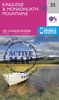
Kingussie And Monadhliath Mountains

Map No. 35, Kingussie and Monadhliath Mountains, in the Ordnance Survey Landranger series at 1:50, 000, including the Cairngorms National Park, Coingnafearn Forest, Kinveachy Forest, Strathdearn, Glen Feshie, Badenoch, Aviemore, Ellan, Kincraig, Lagganlia, Insh, Drumguish, Newtonmore, Laggan, Feagour, Garvamore, Errogie, Lewiston, East Croachy, Tomatin and Clune, with the peaks of Carn a
RIP - This product is no longer available on our network. It was last seen on 25.09.2019

This page now acts as a permanent archive for this product. Add more information using the comments box below to ensure it can still be found by future generations.

Use our search facility to see if it is available from an alternative contributor.
  • Availability: Out Of Stock
  • Supplier: Stanfords
  • SKU: 9780319231180
Availability: In Stock
£5.59

Product Description

Map No. 35, Kingussie & Monadhliath Mountains, in the Ordnance Survey Landranger series at 1:50, 000, including the Cairngorms National Park, Coingnafearn Forest, Kinveachy Forest, Strathdearn, Glen Feshie, Badenoch, Aviemore, Ellan, Kincraig, Lagganlia, Insh, Drumguish, Newtonmore, Laggan, Feagour, Garvamore, Errogie, Lewiston, East Croachy, Tomatin & Clune, with the peaks of Carn a

Reviews/Comments

Add New

Price History

Vouchers

No voucher codes found.
Do you know a voucher code for this product or supplier? Add it to Insights for others to use.

Facebook

Jargon Buster

Forest - A area with a high density of trees

Supplier Information

Stanfords
Stanfords was established in 1853 and opened their iconic Covent Garden flagship store in 1901. They have become the top retailer of maps, travel books and accessories in the UK and arguably offer the largest selection of maps and travel books worldwide. Famous names such as Captain Robert Falcon Scott, Ranulph Fiennes and Michael Palin have purchased from Stanfords. They now have a shop in Bristol and both stores together with other venues operate a calendar of events including talks, book signings and exhibitions. As a specialist map retailer, the map selection is comprehensive and includes road maps, street maps and walking maps from worldwide destinations, as well as a selection of world atlases and wall maps. Books include travel guides and travel literature. Stanfords also stock globes, from miniatures made of blue marble to magnificent floor-standing globes. The website features a selection of interesting articles on travel topics.
Page Updated: 2023-11-12 20:15:36

Community Generated Product Tags

Oh No! The productWIKI community hasn't generated any tags for this product yet!
Menu