More From Contributor
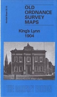
£5.59
Map No. 35, Kingussie & Monadhliath Mountains, in the Ordnance Survey Landranger series at 1:50, 000, including the Cairngorms National Park, Coingnafearn Forest, Kinveachy Forest, Strathdearn, Glen Feshie, Badenoch, Aviemore, Ellan, Kincraig, Lagganlia, Insh, Drumguish, Newtonmore, Laggan, Feagour, Garvamore, Errogie, Lewiston, East Croachy, Tomatin & Clune, with the peaks of Carn a ...
Archived Product
£9.09
Map No. 35, Kingussie & Monadhliath Mountains, in the waterproof & tear-resistant OS Active version of the Ordnance Survey Landranger series at 1:50, 000, including the Cairngorms National Park, Coingnafearn Forest, Kinveachy Forest, Strathdearn, Glen Feshie, Badenoch, Aviemore, Ellan, Kincraig, Lagganlia, Insh, Drumguish, Newtonmore, Laggan, Feagour, Garvamore, Errogie, Lewiston, East Croachy, Tomatin & Clune, with the peaks of Carn a ...
Archived Product
£10.39
Map No. 35, Kingussie & Monadhliath Mountains, in a waterproof & tear-resistant version of the Ordnance Survey Landranger series at 1:50, 000, including the Cairngorms National Park, Coingnafearn Forest, Kinveachy Forest, Strathdearn, Glen Feshie, Badenoch, Aviemore, Ellan, Kincraig, Lagganlia, Insh, Drumguish, Newtonmore, Laggan, Feagour, Garvamore, Errogie, Lewiston, East Croachy, Tomatin & Clune, with the peaks of Carn a ...
Archived Product
£3.50
King`s Cross & St Pancras area of London in 1871-1893 in a series of exceptionally detailed reproductions of old Ordnance Survey street plans for areas of larger cities which have undergone substantial redevelopment in the late 19th or the early 20th century, published in the Alan Godfrey Editions. The plans, printed in back & white, have been taken from the original Ordnance Survey mapping at 1:1, 056 & reproduced at 1:1, 760 – the equivalent of 36 inches (or one yard) to a mile. The maps provide an unrivalled, house-by-house picture of streets & individual buildings with inner courtyards, outbuildings, pavements, covered passages, etc. Many important institutions are named; within the National Galley on Trafalgar Square even the individual rooms (the map is from 1871, so no French Impressionists as yet!). On the reverse are historical notes about the area covered by the map, plus extracts from contemporary street directories. These maps provide a fascinating addition to Alan Godfrey’s huge series of some 2, 000 titles presenting reproductions of street plans at taken from the Ordnance Survey mapping at 1:2, 500 (25” to 1 mile) & reprinted at about 15 inches to one mile (1:4, 340). ...
Archived Product
£14.99
King`s Cross station was the terminus of the Great Northern Railway & was opened in 1852. Designed by Lewis Cubitt, it replaced a temporary station at Maiden Lane. It established itself as the London terminus of what is now known as the East Coast Main Line to Edinburgh. From 1862, at 10 a.m. every weekday, the Flying Scotsman left King`s Cross for the north, initially taking over ten hours to complete the journey but now taking only four hours from Edinburgh to London. Some of Britain`s most famous locomotives, from the Ivatt Atlantics to the A3 & A4 Pacifics, Deltics & HSTs, have sped north from King`s Cross. The underground station below the main line station encompasses six lines & was the scene of the disastrous King`s Cross fire in 1987, following which it was rebuilt. King`s Cross itself has been redeveloped many times over the years, & a fictional platform (93/4) made famous in the Harry Potter novels. Its Grade 1 listed facade has been revamped & the station enhanced to increase capacity. ...
Archived Product
£14.99
King`s Lynn, Downham Market & Swaffham area on a detailed topographic & GPS compatible map No. 236, waterproof version, from the Ordnance Survey’s 1:25, 000 Explorer series.MOBILE DOWNLOADS: this title & all the other OS Explorer maps include a code for downloading after purchase the digital version onto your smartphone or tablet for viewing on the OS smartphone app.OS EXPLORER SERIES: to see the list of all the titles in the OS Explorer series, both paper & waterproof versions, please click on the series link. The Explorer series, Ordnance Survey’s most detailed maps recommended for anyone enjoying outdoor activities, provides topographic coverage of Great Britain at 1:25, 000 on GPS compatible maps with hiking trails, cycling routes & extensive tourist information. Each printed map is available either on paper or as a waterproof & tear-resistant OS Active Map, as indicated in its title. Britain’s National Parks & other areas of particular tourist interest are presented on often double-sided OL (Outdoor Leisure) maps, whilst most standard format Explorers cover an area of 30 x 20km (approx. 19 x 12 miles). All three versions (paper, waterproof & digital) are the same & provide plenty of recreational & tourist information, indicating the traditional public right of way paths (except in Scotland where different laws apply), including bridleways & byways. National Trails & other long-distance paths are marked, as well as permissive footpaths or bridleways & on-road or traffic-free cycle routes with, where appropriate, their National/ Regional Cycle Network numbers. Boundaries of access land are clearly marked. A wide range of symbols provides additional tourist information, highlighting camping & caravanning sites, information offices & visitors’ centres, parking & picnicking places, country pubs, sport & recreational facilities including cycle hire locations & mountain biking trails, historic buildings & museums, etc. Exceptionally clear presentation of the landscape is provided by contours at 5m or in the uplands at 10m intervals, with additional spot heights plus colouring and/or graphics for different types of woodlands, orchards, heath, marshl&, scree or boulders, & other topographic features. For GPS users the maps have British National Grid lines at 1km intervals, with latitude & longitude given by margin ticks at 1`. Clearly laid out map legend

Includes::
French & German translations for the tourist information symbols.

...
Archived Product
£8.99
King`s Lynn, Downham Market & Swaffham area on a detailed topographic & GPS compatible map No. 236, paper version, from the Ordnance Survey’s 1:25, 000 Explorer series. MOBILE DOWNLOADS: this title & all the other OS Explorer maps include a code for downloading after purchase the digital version onto your smartphone or tablet for viewing on the OS smartphone app.OS EXPLORER SERIES: to see the list of all the titles in the OS Explorer series, both paper & waterproof versions, please click on the series link. The Explorer series, Ordnance Survey’s most detailed maps recommended for anyone enjoying outdoor activities, provides topographic coverage of Great Britain at 1:25, 000 on GPS compatible maps with hiking trails, cycling routes & extensive tourist information. Each printed map is available either on paper or as a waterproof & tear-resistant OS Active Map, as indicated in its title. Britain’s National Parks & other areas of particular tourist interest are presented on often double-sided OL (Outdoor Leisure) maps, whilst most standard format Explorers cover an area of 30 x 20km (approx. 19 x 12 miles). All three versions (paper, waterproof & digital) are the same & provide plenty of recreational & tourist information, indicating the traditional public right of way paths (except in Scotland where different laws apply), including bridleways & byways. National Trails & other long-distance paths are marked, as well as permissive footpaths or bridleways & on-road or traffic-free cycle routes with, where appropriate, their National/ Regional Cycle Network numbers. Boundaries of access land are clearly marked. A wide range of symbols provides additional tourist information, highlighting camping & caravanning sites, information offices & visitors’ centres, parking & picnicking places, country pubs, sport & recreational facilities including cycle hire locations & mountain biking trails, historic buildings & museums, etc. Exceptionally clear presentation of the landscape is provided by contours at 5m or in the uplands at 10m intervals, with additional spot heights plus colouring and/or graphics for different types of woodlands, orchards, heath, marshl&, scree or boulders, & other topographic features. For GPS users the maps have British National Grid lines at 1km intervals, with latitude & longitude given by margin ticks at 1`. Clearly laid out map legend

Includes::
French & German translations for the tourist information symbols.

...
Archived Product
£3.50
King’s Norton in 1903 in a fascinating series of reproductions of old Ordnance Survey plans in the Alan Godfrey Editions, ideal for anyone interested in the history of their neighbourhood or family. The map covers most of the village of King`s Norton & extends eastward to Walker`s Heath & Moundsley Hall. Features include Worcester & Birmingham Canal, junction with Stratford Canal, The Green, St Nicholas church, Hurst Mill, Wychall Rolling Mill, Sherborne Mill (at top of map), Broad Meadow, Walker`s Heath, Headley Fields Farm, Moundsley Hall, Icknield Street, etc. On the reverse is a commercial directory of King`s Norton in 1907. About the Alan Godfrey Editions of the 25” OS Series: Selected towns in Great Britain & Ireland are covered by maps showing the extent of urban development in the last decades of the 19th & early 20th century. The plans have been taken from the Ordnance Survey mapping & reprinted at about 15 inches to one mile (1:4, 340). On the reverse most maps have historical notes & many also include extracts from contemporary directories. Most maps cover about one mile (1.6kms) north/south, one & a half miles (2.4kms) across; adjoining sheets can be combined to provide wider coverage.FOR MORE INFORMATION & A COMPLETE LIST OF ALL AVAILABLE TITLES PLEASE CLICK ON THE SERIES LINK. ...
Archived Product
£16.99
Sverigeserien is an outdoor map series consisting of 116 sheets with coverage of southern & central Sweden & the northern coastline. The map is suitable for outdoor activities such as hiking, excursions, trail running, hunting, fishing, riding, cycling, mountain biking, paddling, skating & much more. Every sheet covers an area of 45x 68km. These topographical maps in scale 1:50 000 contain all the information needed for outdoor activities: Terrain information, hiking trails, illuminated tracks, camping, shelters, golf courses, leisure baths, historical remains, roads in different categories, railway lines & much more. Easy to read topography with contour lines, vertical interval 5 m. Sverigeserien is a high-quality map series & is durable for frequent use! Updated content with map data from Lantmäteriet (National Land Survey of Sweden) & printed on Polyart which is water & tear resistant. This means that the map can be folded repeatedly without breaking & can withstand the challenging weather in Sweden during both winter & summer. Legend is in Swedish, English & German. ...
Archived Product
£18.99
Kinnaur: Unfolding Exotic Himalayan Land by O.C. Handa describes one of India least populated & most mountainous administrative districts. Nesting in the Indian Himalayas north-east of Shimla, Kinnaur forms the easternmost corner of Himchal Padesh &

Includes::
Kinnaur Kailash, a mountain sacred both to Hindus & Buddhists. The book is more of an academic study than a travel guide & deals with the various aspects of this remote region, including its geography, history, religious beliefs, culture & festivals, handicrafts, archaeology, etc.

...
Archived Product

King`s Lynn 1904

King`s Lynn in 1904 in a fascinating series of reproductions of old Ordnance Survey plans in the Alan Godfrey Editions, ideal for anyone interested in the history of their neighbourhood or family. The map covers the centre of King`s Lynn, stretching from Alexandra Dock southward to Guanock Terrace. Features include include railways with terminus, Workhouse, St James`s End, Highgate, part of West Lynn, St Nicholas Chapel, St Margaret`s church, All Saints church, Alexandra Dock, Dock Railway, North End, South Quay, part of Gaywood Park, engine shed, St John`s church, Lower Canada, GER Harbour Branch, etc. Extracts from a local directory are on the reverse.About the Alan Godfrey Editions of the 25” OS Series:Selected towns in Great Britain and Ireland are covered by maps
showing the extent of urban development in the last decades of the 19th and early 20th century. The plans have been taken from the Ordnance Survey mapping and reprinted at about 15 inches to one mile (1:4, 340). On the reverse most maps have historical notes and many also include extracts from contemporary directories. Most maps cover about one mile (1.6kms) north/south, one and a half miles (2.4kms) across; adjoining sheets can be combined to provide wider coverage.FOR MORE INFORMATION AND A COMPLETE LIST OF ALL AVAILABLE TITLES PLEASE CLICK ON THE SERIES LINK.
RIP - This product is no longer available on our network. It was last seen on 25.09.2019

This page now acts as a permanent archive for this product. Add more information using the comments box below to ensure it can still be found by future generations.

Use our search facility to see if it is available from an alternative contributor.
  • Availability: Out Of Stock
  • Supplier: Stanfords
  • SKU: 9781847848871
Availability: In Stock
£3.50

Product Description

King`s Lynn in 1904 in a fascinating series of reproductions of old Ordnance Survey plans in the Alan Godfrey Editions, ideal for anyone interested in the history of their neighbourhood or family. The map covers the centre of King`s Lynn, stretching from Alexandra Dock southward to Guanock Terrace. Features include include railways with terminus, Workhouse, St James`s End, Highgate, part of West Lynn, St Nicholas Chapel, St Margaret`s church, All Saints church, Alexandra Dock, Dock Railway, North End, South Quay, part of Gaywood Park, engine shed, St John`s church, Lower Canada, GER Harbour Branch, etc. Extracts from a local directory are on the reverse. About the Alan Godfrey Editions of the 25” OS Series: Selected towns in Great Britain & Ireland are covered by maps showing the extent of urban development in the last decades of the 19th & early 20th century. The plans have been taken from the Ordnance Survey mapping & reprinted at about 15 inches to one mile (1:4, 340). On the reverse most maps have historical notes & many also include extracts from contemporary directories. Most maps cover about one mile (1.6kms) north/south, one & a half miles (2.4kms) across; adjoining sheets can be combined to provide wider coverage.FOR MORE INFORMATION & A COMPLETE LIST OF ALL AVAILABLE TITLES PLEASE CLICK ON THE SERIES LINK.

Reviews/Comments

Add New

Intelligent Comparison

Oooops!
We couldn't find anything!
Perhaps this product's unique.... Or perhaps we are still looking for comparisons!
Click to bump this page and we'll hurry up.

Price History

Vouchers

No voucher codes found.
Do you know a voucher code for this product or supplier? Add it to Insights for others to use.

Facebook

Jargon Buster

Contemporary - Modern era design
Engine - A machine designed to convert fuel into motion
Contemporary - A design reference to indicate post war modern design
History - Anything that happens in the past. An acedemic subject.
Railways - A set of tracks that have been laid for the purpose of trains to travel up and down them
King - The figure head of a monarch
Contemporary - An object that is living in the same time.
Ideal - Something that satisfies a perfect criteria.
Family - A group of people that live together made up from parents and children.

Supplier Information

Stanfords
Stanfords was established in 1853 and opened their iconic Covent Garden flagship store in 1901. They have become the top retailer of maps, travel books and accessories in the UK and arguably offer the largest selection of maps and travel books worldwide. Famous names such as Captain Robert Falcon Scott, Ranulph Fiennes and Michael Palin have purchased from Stanfords. They now have a shop in Bristol and both stores together with other venues operate a calendar of events including talks, book signings and exhibitions. As a specialist map retailer, the map selection is comprehensive and includes road maps, street maps and walking maps from worldwide destinations, as well as a selection of world atlases and wall maps. Books include travel guides and travel literature. Stanfords also stock globes, from miniatures made of blue marble to magnificent floor-standing globes. The website features a selection of interesting articles on travel topics.
Page Updated: 2023-11-12 20:15:36

Community Generated Product Tags

Oh No! The productWIKI community hasn't generated any tags for this product yet!
Menu