
 United Kingdom
 France
 Germany
 Netherlands
 Sweden
 USA
USA
 Italy
Italy
 Spain
Spain
More From Contributor

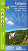

Kelso And Coldstream
Map No. 74, Kelso and Coldstream, in the Ordnance Survey Landranger series at 1:50, 000, including Jedburgh, Duns, Oreston, Longformacus, Chirnside, Foulden, Hutton, Paxton, Whitsome, Polwarth, Westruther, Blythe, Bassendean, Greenlaw, Swinton, Horncliffe, Norham, Leitholm, Eccles, Gordon, Legerwood, Earlston, Stichill, Castle Heaton, Ford, Branxton, Sprouston, Smailholm, St Boswells, Kilham, Milfield, Kirk Yetholm, Roxburgh, Ancrum, Crailing, Morebattle and Hethpool, with the Northumberland National Park including the peak of The Cheviot and the end of the Pennine Way, plus the Lammermuir Hills with the Southern Upland Way. Edition C1; Revised 2002; Revised for selected changes 2008; Copyright 2008 This title is also available on our website in a
waterproof and tear-resistant version.Maps in this series are only published folded. Stanfords can also print flat versions of Ordnance Survey maps through the OS Select system, centring the map on a location of your choice and with a picture provided by you on the cover. For more information please click on the link at the bottom of this description.About Ordnance Survey
waterproof and tear-resistant version.Maps in this series are only published folded. Stanfords can also print flat versions of Ordnance Survey maps through the OS Select system, centring the map on a location of your choice and with a picture provided by you on the cover. For more information please click on the link at the bottom of this description.About Ordnance Survey
Product Description
Reviews/Comments
Add New
Intelligent Comparison
Archived Product
Kelso And Coldstream WATERPROOF Stanfords
£10.39
Archived Product
Kelso And Coldstream OS ACTIVE Map Stanfords
£9.09
Vouchers
No voucher codes found.
Do you know a voucher code for this product or supplier? Add it to Insights for others to use.
Do you know a voucher code for this product or supplier? Add it to Insights for others to use.
 Denmark