
 United Kingdom
 France
 Germany
 Netherlands
 Sweden
 USA
USA
 Italy
Italy
 Spain
Spain
More From Contributor


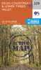

Kelso And Coldstream OS ACTIVE Map
Map No. 74, Kelso and Coldstream, in the waterproof and tear-resistant OS Active version of the Ordnance Survey Landranger series at 1:50, 000, including Jedburgh, Duns, Oreston, Longformacus, Chirnside, Foulden, Hutton, Paxton, Whitsome, Polwarth, Westruther, Blythe, Bassendean, Greenlaw, Swinton, Horncliffe, Norham, Leitholm, Eccles, Gordon, Legerwood, Earlston, Stichill, Castle Heaton, Ford, Branxton, Sprouston, Smailholm, St Boswells, Kilham, Milfield, Kirk Yetholm, Roxburgh, Ancrum, Crailing, Morebattle and Hethpool, with the Northumberland National Park including the peak of The Cheviot and the end of the Pennine Way, plus the Lammermuir Hills with the Southern Upland Way.Edition C1; Publication date April 2012About Ordnance Survey
Product Description
Reviews/Comments
Add New
Vouchers
No voucher codes found.
Do you know a voucher code for this product or supplier? Add it to Insights for others to use.
Do you know a voucher code for this product or supplier? Add it to Insights for others to use.
 Denmark