
 United Kingdom
 France
 Germany
 Netherlands
 Sweden
 USA
USA
 Italy
Italy
 Spain
Spain
More From Contributor


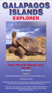
Galapagos Islands Explorer
Galapagos Islands on a map from Ocean Explorer Publications with a very extensive guide section providing descriptions of individual islands, historical notes, etc., all illustrated with numerous photos and drawings.On one side is a map showing the whole archipelago at approx. 1:400, 000, with the islands topography presented by relief shading, altitude colouring and names of peaks and bays. Towns and settlements, roads, and airports are all marked. The map has latitude and longitude lines at intervals of 30’. Surrounding the map are extensive notes about each island.The reverse side is covered by further notes, including history of the Galapagos with a time line, biographies of notable explorers, notes the islands’ fauna, flora and volcanic structure, drawings of
Darwin’s finches, maps of Darwin’s route on the Beagle and of the underlying sea currents, etc.
Darwin’s finches, maps of Darwin’s route on the Beagle and of the underlying sea currents, etc.

Product Description
Reviews/Comments
Add New
Intelligent Comparison
Archived Product
Galapagos Islands Stanfords
£18.00
Archived Product

Falkland Islands Explorer Stanfords
£7.99
Archived Product
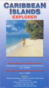
Caribbean Islands Explorer Stanfords
£9.99
Archived Product
Galapagos Islands Spotlight Guide Stanfords
£4.99
Archived Product

Moon Galapagos Islands Stanfords
£11.99
Vouchers
No voucher codes found.
Do you know a voucher code for this product or supplier? Add it to Insights for others to use.
Do you know a voucher code for this product or supplier? Add it to Insights for others to use.
 Denmark