
 United Kingdom
 France
 Germany
 Netherlands
 Sweden
 USA
USA
 Italy
Italy
 Spain
Spain
More From Contributor


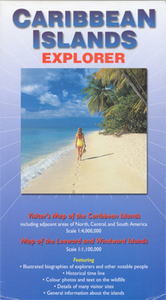
Caribbean Islands Explorer
A title designed to provide general introduction to the Caribbean, with more historical than geographical information, on an overview map of the whole region at 1:4, 000, 000 plus an enlargement at 1:1, 000, 000 covering the Leeward and the Windward Islands. Main towns are marked with, where possible on larger islands, some roads and spot height for main peaks. All the countries and dependencies, as well as main places of interest along the surrounding coastal areas of the mainland, are accompanied by descriptions of their history. The map also includes brief biographies of notable people connected with the region, from Columbus and Amerigo Vespucci to Fidel Castro, general notes on the region’s history, geography and wildlife, and a time-line of important events from 1490 to
1995.
1995.

Product Description
Reviews/Comments
Add New
Intelligent Comparison
Archived Product
Caribbean Islands Stanfords
£13.59
Archived Product
Caribbean Islands Stanfords
£14.99
Archived Product

Falkland Islands Explorer Stanfords
£7.99
Archived Product
Caribbean Island Dreams Stanfords
£19.95
Archived Product
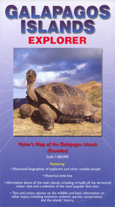
Galapagos Islands Explorer Stanfords
£9.99
Archived Product
Caribbean Islands SUPERCEDED Stanfords
£15.99
Vouchers
No voucher codes found.
Do you know a voucher code for this product or supplier? Add it to Insights for others to use.
Do you know a voucher code for this product or supplier? Add it to Insights for others to use.
 Denmark