More From Contributor

£14.99
Waterton Lakes National Park in British Columbia with the northern part of the Glacier National Park across the US border in Montana at 1:50, 000 on a light, waterproof & tear-resistant map from Gem Trek with descriptions of recommended treks & bike trails, etc. Contours are at 25m intervals, enhanced by relief shading & colouring for different types of terrain & vegetations. Very extensive overprint highlights hiking trails, indicating routes described on the reverse side of the map, plus biking, horse riding & ski routes, unmaintained trails, etc, all annotated with distances. Symbols mark various places of interest & facilities for visitors, including different types of accommodation. The map has a 1-km UTM grid, On the reverse side are descriptions of recommended hiking routes: 7 easy, 3 moderate & 7 strenuous day hikes, several overnight trips, plus a selection of biking & bike-&-hike trails. Also provided is information on local services including campgrounds. To see the list of titles in this series please click on the series link. ...
Archived Product
£8.25
Map No. 62, Wexford North
- Wicklow South in the Discovery series from the OSI, the Ordnance Survey of Irel&, which presents
...
Archived Product
£6.95
Wall map of Wales & Central England at 1:316, 800 (5 miles to 1 inch) from Geographers` A-Z Map Company for traditionalists who prefer their maps drawn at scales corresponding to the imperial measurements of miles to inches, with colourful presentation of topography & hill heights in feet. Presentation of the topography varies slightly, from bold altitude colouring in older editions to slightly gentler colours enhanced by relief shading on more recent maps, both very effectively showing the more hilly or mountainous parts of the country. All maps have spot heights shown in feet. The colouring of the road network clearly distinguishes between primary routes & other A roads for route planning, with B roads also easy to follow on all backgrounds. Smaller country roads are less clear to see, with the publishers recommending their alternative series for more detailed local coverage. Railway lines are included & shown with stations, but at times difficult to find. British national grid lines are overprinted on the cartography & a separate booklet is supplied containing the index to cities, towns, villages, hamlets & locations.* *IMPORTANT
- PLEASE NOTE: many place names & all additional tourist information is in very small lettering, requiring good eyesight or a magnifying glass.*
...
Archived Product
£12.95
This guidebook describes 35 varied day walks in the Chilterns Area of Outstanding Natural Beauty in southern Engl&. The Chiltern Hills follow a line of chalk from the River Thames at Goring up to the Barton Hills just west of Hitchin, through Oxfordshire, Buckinghamshire, Hertfordshire & Bedfordshire, with great views from the north west edge &, on the south east side, a more intimate undulating landscape of rounded hills & valleys, covered in a mix of broadleaved woodland & open farml&. The walks take you on a journey through this classic Chiltern landscape that has been shaped by human activity for thousands of years, visiting interesting historic sites, colourful gardens & picture-postcard villages with thatched cottages, fascinating churches & cosy pubs. Step by step route directions include lots of information about all these sites along the way & are illustrated with clear OS mapping & vibrant photographs. Written by a real local enthusiast. ...
Archived Product
£16.95
The Corbetts (Scotland`s 2500-2999ft mountains) are every bit as interesting as the Munros (3000ft & over), often clear when the Munros are in cloud, walkable on short winter days, free of the peak-bagging crowds of their taller neighbours. Volume 2 of this two-volume Cicerone guide covers the Corbetts to the north of the Great Glen, which runs from Fort William to Inverness enclosing Loch Ness, probably Scotland`s best-known loch. Choosing the best, rather than the quickest, routes up each summit the author covers 109 peaks in 90 routes, divided into 10 areas. South of the Great Glen it is the Munros which attract most attention, but along the western seaboard & in the far north it is the Corbetts that dominate the landscape with isolated rocky peaks rising steeply above the sea & inland lochs, in a wilderness of heather & bog dotted with sparkling lochs & lochans. There are spectacular Corbetts all the way from Ardgour to Cape Wrath including those in Ardgour, Knoydart, Applecross, Torridon & Fisherfield. The far north-west provides some of the most magnificent mountain scenery in the world & it is difficult to beat the magical islands of Mull, Rum, Skye & Harris. ...
Archived Product
£12.95
In this guidebook, ` Essex` means the historic county including the London boroughs east of the Lea, roughly equivalent to the post-Roman Kingdom of the East Saxons. Water, important then as now to the defender of a contested territory, defines most of its boundaries: the North Sea to the east, the Thames to the south, the Lea & Stort to the west, & the Stour to the north. Each of these has a character very different to the others, & this one fact alone gives a variety to the landscape. Within this area, so accessible from London, lie a whole range of inland & coastal landscapes, some as empty & remote as anywhere in Engl&, & four great surviving forests
- Hainault, Hatfield, Epping & Writtle. This guidebook describes the 25 best day walks right across the area, ranging in length from 4 to 18 miles, 22 circular & 3 linear, but none of them particularly hilly with the highest point in the county only 482ft. Packed with historical & geological information, these routes, in addition to the 11-stage Across Essex route, take you step by step into every nook & cranny of a surprising county.
...
Archived Product
£6.95
Wallpaper* City Guides present a tightly edited, discreetly packaged list of the best a location has to offer the design conscious traveller. Here is a precise, informative, insider`s checklist of all you need to know about the world`s most intoxicating cities. Whether you are staying for 48 hours or five days, visiting for business or a vacation, we`ve done the hard work for you, from finding the best restaurants, bars & hotels (including which rooms to request) to the most extraordinary stores & sites, & the most enticing architecture & design. Wallpaper* City Guides enable you to come away from your trip, however brief, with a real taste of the city`s landscape & the satisfaction you`ve seen all that you should. In short, these guides act as a passport to the best the world has to offer. ...
Archived Product
£14.95
Walking guide to Gran Canaria in the Canary Islands, describing 45 day walks & sections of the new, waymarked, long-distance trail GR131. The fourth in a comprehensive five-book series covering all the Canaries, it

Includes::
from Las Palmas in the north to the southern Playa del Ingles, with the stunning volcanic hill-country in between, all illustrated with detailed contour maps. The guide has walks suitable for those of all abilities, the dramatic landscape little known outside of the Canaries, but offering an ideal winter walking destination featuring rocky treks & mountain paths, clifftop & beachfront walks & forest trails through varied, breathtaking scenery. The guide provides lots of background information on geology, wildlife, plants & flowers as well as practical information on accommodation, currency & language.

...
Archived Product
£6.95
Wallpaper* City Guides present a tightly edited, discreetly packaged list of the best a location has to offer the design conscious traveller. Here is a precise, informative, insider`s checklist of all you need to know about the world`s most intoxicating cities. Whether you are staying for 48 hours or five days, visiting for business or a vacation, we`ve done the hard work for you, from finding the best restaurants, bars & hotels (including which rooms to request) to the most extraordinary stores & sites, & the most enticing architecture & design. Wallpaper* City Guides enable you to come away from your trip, however brief, with a real taste of the city`s landscape & the satisfaction you`ve seen all that you should. In short, these guides act as a passport to the best the world has to offer. ...
Archived Product

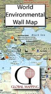
Environmental World Global Mapping Wall Map PAPER

The Environmental World Wall Map from Global Mapping, 123 x 94cm (4ft x 3ft 1” approx.) and with laminated surface, showing a physical world map annotated with various environmental problems, with additional panels on deforestation, urbanization, land degradation, climate influences, etc.The main map shows the land masses with altitude colouring and relief shading to show the geography: mountain ranges, deserts, etc. Country names and boundaries are marked, plus a selection of cities, with those most polluted indicated by a special symbol. Other symbols indicate various environmental issues grouped into three types: man-made pollution (nuclear test sites and accidents, oil spills, etc), natural phenomena (deforestation, desertification, droughts, etc) and environmental
impacts (pollution black spots, coral bleaching, areas affected by acid rain, etc).Panels under the map provided world maps dealing with deforestation, urbanization, land degradation and climate influences. Another panel shows the environmental changes in the Arctic. Also included are lists of worst oil spills and areas with worst air pollution, plus notes on acid rain and environmental hotspots.*LAMINATED and ENCAPSULATED WALL MAPS:**Laminated* wall maps have a thin layer of plastic usually applied to the printed side only. They can be written on with suitable marker pens without any damage to the map but, unless laminated on both sides, they are not damp-proof.*Encapsulated* wall maps are sealed between two sheets of plastic. They are more rigid and heavier than laminated maps of
the same size. They are damp-proof and do not crinkle in humid conditions. Encapsulation gives the map a shiny surface, similar to being displayed behind glass.Many publishers and retailers often use these two terms interchangeably. Our map titles and descriptions follow the definitions provided above.
RIP - This product is no longer available on our network. It was last seen on 25.09.2019

This page now acts as a permanent archive for this product. Add more information using the comments box below to ensure it can still be found by future generations.

Use our search facility to see if it is available from an alternative contributor.
  • External links may include paid for promotion
  • Availability: Out Of Stock
  • Supplier: Stanfords
  • SKU: 9781905755547
Availability: In Stock
£19.99

Product Description

The Environmental World Wall Map from Global Mapping, 123 x 94cm (4ft x 3ft 1” approx.) & with laminated surface, showing a physical world map annotated with various environmental problems, with additional panels on deforestation, urbanization, land degradation, climate influences, etc. The main map shows the land masses with altitude colouring & relief shading to show the geography: mountain ranges, deserts, etc. Country names & boundaries are marked, plus a selection of cities, with those most polluted indicated by a special symbol. Other symbols indicate various environmental issues grouped into three types: man-made pollution (nuclear test sites & accidents, oil spills, etc), natural phenomena (deforestation, desertification, droughts, etc) & environmental impacts (pollution black spots, coral bleaching, areas affected by acid rain, etc). Panels under the map provided world maps dealing with deforestation, urbanization, land degradation & climate influences. Another panel shows the environmental changes in the Arctic. Also included are lists of worst oil spills & areas with worst air pollution, plus notes on acid rain & environmental hotspots.*LAMINATED & ENCAPSULATED WALL MAPS:** Laminated* wall maps have a thin layer of plastic usually applied to the printed side only. They can be written on with suitable marker pens without any damage to the map but, unless laminated on both sides, they are not damp-proof.* Encapsulated* wall maps are sealed between two sheets of plastic. They are more rigid & heavier than laminated maps of the same size. They are damp-proof & do not crinkle in humid conditions. Encapsulation gives the map a shiny surface, similar to being displayed behind glass. Many publishers & retailers often use these two terms interchangeably. Our map titles & descriptions follow the definitions provided above.

Reviews/Comments

Add New

Price History

Vouchers

No voucher codes found.
Do you know a voucher code for this product or supplier? Add it to Insights for others to use.

Facebook

Jargon Buster

Paper - A thin sheet mainly used for writing. Available in a variety of colours. Made mainly from wood pulp.
Black - A colour which does not emit any colour of the spectrum. Black absorbs all frequencies of the spectrum.
Plastic - A generic term for a synthetic product used in the manufacture of products
Glass - A solid, typically transparent. Brittle and used in windows. The first patent granted in the UK was for Glass.
Oil - A hydrophobic liquid with high carbon and hydrogen content. Has many variations including; cooking oils, petrochemical oils, essential oils.
Physical - Used to describe strength or visual properties of an item
Wall - A physical barrier between two areas
World - A physical grouping, commonly used to describe earth and everything associated with ti
Size - is the measurement of how big an object is in space.
Natural - not manmade
Altitude - Something that can be quite high in relation to sea or ground level.
Layer - Adding extra quantities of materials for extra practical benefits, e.g. warmth.
Laminated - A thin layer of plastic that gives a coating and shine to a material.
Shiny - A smooth reflective surface, e.g. a metal spoon.
Humid - When water vapour is high in the atmosphere making it feel stuffy.

Supplier Information

Stanfords
Stanfords was established in 1853 and opened their iconic Covent Garden flagship store in 1901. They have become the top retailer of maps, travel books and accessories in the UK and arguably offer the largest selection of maps and travel books worldwide. Famous names such as Captain Robert Falcon Scott, Ranulph Fiennes and Michael Palin have purchased from Stanfords. They now have a shop in Bristol and both stores together with other venues operate a calendar of events including talks, book signings and exhibitions. As a specialist map retailer, the map selection is comprehensive and includes road maps, street maps and walking maps from worldwide destinations, as well as a selection of world atlases and wall maps. Books include travel guides and travel literature. Stanfords also stock globes, from miniatures made of blue marble to magnificent floor-standing globes. The website features a selection of interesting articles on travel topics.
Page Updated: 2023-11-12 20:15:36

Community Generated Product Tags

Oh No! The productWIKI community hasn't generated any tags for this product yet!
Menu