More From Contributor

£16.95
The Corbetts (Scotland`s 2500-2999ft mountains) are every bit as interesting as the Munros (3000ft & over), often clear when the Munros are in cloud, walkable on short winter days, free of the peak-bagging crowds of their taller neighbours. Volume 2 of this two-volume Cicerone guide covers the Corbetts to the north of the Great Glen, which runs from Fort William to Inverness enclosing Loch Ness, probably Scotland`s best-known loch. Choosing the best, rather than the quickest, routes up each summit the author covers 109 peaks in 90 routes, divided into 10 areas. South of the Great Glen it is the Munros which attract most attention, but along the western seaboard & in the far north it is the Corbetts that dominate the landscape with isolated rocky peaks rising steeply above the sea & inland lochs, in a wilderness of heather & bog dotted with sparkling lochs & lochans. There are spectacular Corbetts all the way from Ardgour to Cape Wrath including those in Ardgour, Knoydart, Applecross, Torridon & Fisherfield. The far north-west provides some of the most magnificent mountain scenery in the world & it is difficult to beat the magical islands of Mull, Rum, Skye & Harris. ...
Archived Product
£19.99
The Environmental World Wall Map from Global Mapping, 123 x 94cm (4ft x 3ft 1” approx.) & with laminated surface, showing a physical world map annotated with various environmental problems, with additional panels on deforestation, urbanization, land degradation, climate influences, etc. The main map shows the land masses with altitude colouring & relief shading to show the geography: mountain ranges, deserts, etc. Country names & boundaries are marked, plus a selection of cities, with those most polluted indicated by a special symbol. Other symbols indicate various environmental issues grouped into three types: man-made pollution (nuclear test sites & accidents, oil spills, etc), natural phenomena (deforestation, desertification, droughts, etc) & environmental impacts (pollution black spots, coral bleaching, areas affected by acid rain, etc). Panels under the map provided world maps dealing with deforestation, urbanization, land degradation & climate influences. Another panel shows the environmental changes in the Arctic. Also included are lists of worst oil spills & areas with worst air pollution, plus notes on acid rain & environmental hotspots.*LAMINATED & ENCAPSULATED WALL MAPS:** Laminated* wall maps have a thin layer of plastic usually applied to the printed side only. They can be written on with suitable marker pens without any damage to the map but, unless laminated on both sides, they are not damp-proof.* Encapsulated* wall maps are sealed between two sheets of plastic. They are more rigid & heavier than laminated maps of the same size. They are damp-proof & do not crinkle in humid conditions. Encapsulation gives the map a shiny surface, similar to being displayed behind glass. Many publishers & retailers often use these two terms interchangeably. Our map titles & descriptions follow the definitions provided above. ...
Archived Product
£12.95
In this guidebook, ` Essex` means the historic county including the London boroughs east of the Lea, roughly equivalent to the post-Roman Kingdom of the East Saxons. Water, important then as now to the defender of a contested territory, defines most of its boundaries: the North Sea to the east, the Thames to the south, the Lea & Stort to the west, & the Stour to the north. Each of these has a character very different to the others, & this one fact alone gives a variety to the landscape. Within this area, so accessible from London, lie a whole range of inland & coastal landscapes, some as empty & remote as anywhere in Engl&, & four great surviving forests
- Hainault, Hatfield, Epping & Writtle. This guidebook describes the 25 best day walks right across the area, ranging in length from 4 to 18 miles, 22 circular & 3 linear, but none of them particularly hilly with the highest point in the county only 482ft. Packed with historical & geological information, these routes, in addition to the 11-stage Across Essex route, take you step by step into every nook & cranny of a surprising county.
...
Archived Product
£6.95
Wallpaper* City Guides present a tightly edited, discreetly packaged list of the best a location has to offer the design conscious traveller. Here is a precise, informative, insider`s checklist of all you need to know about the world`s most intoxicating cities. Whether you are staying for 48 hours or five days, visiting for business or a vacation, we`ve done the hard work for you, from finding the best restaurants, bars & hotels (including which rooms to request) to the most extraordinary stores & sites, & the most enticing architecture & design. Wallpaper* City Guides enable you to come away from your trip, however brief, with a real taste of the city`s landscape & the satisfaction you`ve seen all that you should. In short, these guides act as a passport to the best the world has to offer. ...
Archived Product
£14.95
With over 80 routes, this handy guidebook by an expert author offers walkers many opportunities to explore the ridges, plateaus, glens & woodland of highland Perthshire. The area covered here relates to the old county boundary & is bound by the Dalwhinnie to the north, Crieff & Dunkeld to the south east & stretching to Bridge of Orchy in the west. The long grass slopes & peaty cols provide a wealth of walking opportunitites, on heather & pebble-strewn plateaux & rounded ridges. & in March & April the soggy grass becomes crisp snow, the boggy cols freeze over & Ben Lawers & Meall nan Tarmachan look all Alpine along the skyline. The graded routes described here include all 42 Munros in the area as well as 22 selected Corbetts, 15 smaller summits & the historic Atholl passes of Gaick & Minigaig
- all within easy reach of Perth. Routes are grouped into ten geographical areas: Comrie & Crieff, Killin & Glen Lochay, Glen Lyon, Bridge of Orchy, Perth & Dunkeld, Aberfeldy, Tummel & Loch Rannoch, Rannoch Moor, Pitlochry & Blair Atholl & Drumochter.A combination of 1:50, 000 & 1:100, 000 mapping is included as appropriate along with the author`s unforgettable photographs.
...
Archived Product
£8.25
Map No. 75, Waterford North in the Discovery series from the OSI, the Ordnance Survey of Irel&, which presents the country on detailed topographic maps at 1:50, 000, with additional overprint highlighting campsites & caravan parks, youth hostels, etc. Current 4th edition of this map was published in January 2013. Maps in the Discovery series have contours at 10m intervals, with plenty of spot heights & additional altitude colouring. Graphics indicate different types of woodlands. An overprint highlights waymarked or unmarked walking trails as well as cycle routes. National or forest parks & nature reserves are marked & a range of symbols provide tourist information: campsites, caravan parks, youth hostels (An Óige & independent), tourist offices, parking & picnic places, & viewpoints. Golf courses indicate the number of holes. The maps also highlight antiquities & historical sites such as megalithic tombs, standing stones, battlefields, etc. Road network grades third class roads according to their widths &

Includes::
local tracks. Railways are shown with stations & the maps include other details expected of topographic mapping at this scale. Where appropriate, place names are given in both Irish & English. Each map covers an area of 40 x 30km (25 x 19 miles approximately) & has a 1km ITM (Irish Transverse Mercator) grid, plus latitude & longitude margin ticks at 1` intervals. Map legend is in Irish & English. To see the list of all the titles in this series please click on the series link.

...
Archived Product
£14.99
Lonely Planet Wales offers advice on what to see, what to skip, & what hidden discoveries await you. Uncover history in medieval castles, eat at the country`s best gastro-pubs, or hike the Wales Coast Path. Highlights & itineraries show you the simplest way to tailor your trip to your own personal needs & interests. Insider tips save you time & money, & help you get around like a local, avoiding crowds & trouble spots. Essential info at your fingertips
- including hours of operation, phone numbers, websites, transit tips, & prices. Honest reviews for all budgets
- including eating, sleeping, sight-seeing, going out, shopping, & hidden gems that most guidebooks miss. Cultural insights give you a richer & more rewarding travel experience
- including history, literature, music, architecture & landscapes. Over fifty maps. Useful features
- including Walking Tours, Outdoor Activities, & Month by Month (annual festival calendar). Coverage of Cardiff, the Gower Peninsula, Pembrokeshire, Snowdonia & more. Looking for more extensive coverage? Check out Lonely Planet`s Great Britain guide.


...
Archived Product
£5.99
With Lonely Planet`s Western Europe Phrasebook & Dictionary, let no barriers
- language or culture
- get in your way. Get more

...
Archived Product

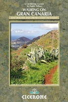
Gran Canaria Walking Guide

Walking guide to Gran Canaria in the Canary Islands, describing 45 day walks and sections of the new, waymarked, long-distance trail GR131. The fourth in a comprehensive five-book series covering all the Canaries, it includes from Las Palmas in the north to the southern Playa del Ingles, with the stunning volcanic hill-country in between, all illustrated with detailed contour maps. The guide has walks suitable for those of all abilities, the dramatic landscape little known outside of the Canaries, but offering an ideal winter walking destination featuring rocky treks and mountain paths, clifftop and beachfront walks and forest trails through varied, breathtaking scenery. The guide provides lots of background information on geology, wildlife, plants and flowers as well as
practical information on accommodation, currency and language.
RIP - This product is no longer available on our network. It was last seen on 25.09.2019

This page now acts as a permanent archive for this product. Add more information using the comments box below to ensure it can still be found by future generations.

Use our search facility to see if it is available from an alternative contributor.
  • External links may include paid for promotion
  • Availability: Out Of Stock
  • Supplier: Stanfords
  • SKU: 9781852846022
Availability: In Stock
£14.95

Product Description

Walking guide to Gran Canaria in the Canary Islands, describing 45 day walks & sections of the new, waymarked, long-distance trail GR131. The fourth in a comprehensive five-book series covering all the Canaries, it

Includes::
from Las Palmas in the north to the southern Playa del Ingles, with the stunning volcanic hill-country in between, all illustrated with detailed contour maps. The guide has walks suitable for those of all abilities, the dramatic landscape little known outside of the Canaries, but offering an ideal winter walking destination featuring rocky treks & mountain paths, clifftop & beachfront walks & forest trails through varied, breathtaking scenery. The guide provides lots of background information on geology, wildlife, plants & flowers as well as practical information on accommodation, currency & language.

Reviews/Comments

Add New

Intelligent Comparison

Oooops!
We couldn't find anything!
Perhaps this product's unique.... Or perhaps we are still looking for comparisons!
Click to bump this page and we'll hurry up.

Price History

Vouchers

No voucher codes found.
Do you know a voucher code for this product or supplier? Add it to Insights for others to use.

Facebook

Jargon Buster

Forest - A area with a high density of trees
Day - The time it takes a planet or other space objects to complete one rotation.
Language - the method of communication used in different areas. Humans and computers have many different languages.
Accommodation - A room in which someone can live in, for example in a hotel
Winter - The fourth season of a year that comes between Spring and Autumn
Practical - Weather a task is easy to carry out and realistically succeed.
Ideal - Something that satisfies a perfect criteria.
Language - The way humans communicate either written and spoken.

Supplier Information

Stanfords
Stanfords was established in 1853 and opened their iconic Covent Garden flagship store in 1901. They have become the top retailer of maps, travel books and accessories in the UK and arguably offer the largest selection of maps and travel books worldwide. Famous names such as Captain Robert Falcon Scott, Ranulph Fiennes and Michael Palin have purchased from Stanfords. They now have a shop in Bristol and both stores together with other venues operate a calendar of events including talks, book signings and exhibitions. As a specialist map retailer, the map selection is comprehensive and includes road maps, street maps and walking maps from worldwide destinations, as well as a selection of world atlases and wall maps. Books include travel guides and travel literature. Stanfords also stock globes, from miniatures made of blue marble to magnificent floor-standing globes. The website features a selection of interesting articles on travel topics.
Page Updated: 2023-11-12 20:15:36

Community Generated Product Tags

Oh No! The productWIKI community hasn't generated any tags for this product yet!
Menu