More From Contributor
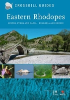
£12.00
Eastern Nepal Rafting & Kayaking Map at 1:500, 000 from the Nepa Maps (Himalayan Map House) designed to present the country’s river network classified according to the suitability for white water rafting & kayaking, with water volume profiles, etc. This title is part of a series covering Nepal on three maps showing the river network graded into five classes. Additional panels list rivers with rafting & kayaking summaries, providing stretch-by stretch information about class, volume, scenery, number of days, etc. Also provided are month-by-month profiles of high & low water ratios. The maps have relief shading to show Nepal’s topography & present the country’s network of roads & tracks, with symbols highlighting locations of local airports, campsites & other tourist accommodation, various places of interest, etc. The maps are indexed & have latitude & longitude lines at intervals of 30’. All the information is in English. ...
Archived Product
£15.99
Eastern Pomerania at 1:200, 000 from Höfer Verlag in a series of road maps of areas which used to be part of Germany or the Austro-Hungarian Empire, showing both current & the old German place names. In many places former settlements which now no longer exist are also named. Present road & rail networks are supplemented by historical information, e.g. former railway lines. There is no relief detail apart from spot heights. Forests, nature reserves, national park boundaries & locations of interest are marked, & symbols indicate campsites, historical sites, etc. The maps have no geographical coordinates. * Map legend

Includes::
English.* As the maps have dual place names, the print is rather small, but each title comes with a special magnifying lens attached to the map cover. Also included is a booklet with separate, cross-referenced indexes for each set of names & a street plan of the central part of the area’s main city, showing both old & current street layout.* In this title:* a street plan of central Gdansk/ Danzig.

...
Archived Product
£14.99
Eastern Provence in the Sunflower Landscapes guide series; exploring the best walking & touring possibilities in the region or area. Detailed information about touring by hired car or public transport, as well as on foot, is provided, helping walkers to navigate & plan day-trips. Shorter strolls are also included as an alternative for each main route for those seeking more leisurely days out. The guide is structured in two main parts – Touring & Walking – that explore each route with detailed references to public transport & car directions to make each walk more accessible. Suggested car-touring routes of the area are also included. Each describes a route by car with suggestions for stop-off places & things to see on the way, including any picnicking sites. Fifteen suggestions for the best picnic stops are included at the start of the book & these are cross-referenced with the fold-out map & walk descriptions. The ‘ Walking’ section

Includes::
fifteen recommended walks, many of which are circular tours. A detailed introduction provides information on waymarking & maps, what to take, weather & where to stay. Each walk begins with information about distance, difficulty grading, waymarking, how to get there, suggested clothing & equipment, language hints & shorter & alternative routes to the main walk. An appendice provides useful guidance on local transport. Colour photographs & Ordnance Survey extracts accompany each route.

...
Archived Product
£6.99
An amalgamation of many cultures, the Eastern Pyrenees is a fantastic region to visit. From towering mountainscapes in Aragon, to the exotic buzz of Perpignan, to the proud Catalan capital, Barcelona; the Eastern Pyrenees truly offer something for everyone. Footprint Focus provides invaluable information on transport, accommodation, eating & entertainment to ensure that your trip

Includes::
the best of this vibrant region of Europe. Essentials section with useful advice on getting to & around the Eastern Pyrenees. Comprehensive, up-to-date listings of where to eat, sleep & play.

Includes::
information on tour operators & activities, from hot-air balloon rides to astounding architecture. Detailed maps for the key destinations in the Eastern Pyrenees. Slim enough to fit in your pocket. With detailed information on all the main sights, plus many lesser-known attractions, Footprint Focus Eastern Pyrenees (
Includes: Barcelona & Perpignan) provides concise & comprehensive coverage of one of Europe's most dynamic regions.


...
Archived Product
£7.99
Eastern Rhodope Mountains on a detailed road map at 1:120, 000 from Domino with a street plan of Zlatograd, brief descriptions of 87 places of interest, plus on the reverse plans of the archaeological remains at Perperikon & Tatul. On one side is a detailed road map of the eastern part of the Rhodope Mountain along the Greek border. Coverage extends from Zlatagrad in the south-west to Svilengrad in the north-eastern corner. Topography is shown by contours at 50m intervals with faint relief shading & spot heights, plus colouring for forested areas. Boundaries of protected areas are indicated. All place names apart from selected towns plus locations cross-referenced to the descriptions are given in Cyrillic alphabet only. Road network

Includes::
dirt roads or tracks & selected local paths. Railway lines are shown with stations & stops. Various places of interest are highlighted by small drawings and/or cross-referenced to English language descriptions next to the map. The map has no geographical coordinates or an index. Map legend

Includes::
English. Also provided is a street plan of Zlatograd with a brief description of its sites & a Bulgarian only legend. The whole of the reverse side is taken up by 3-D drawings of the archaeological remains at Perperikon & Tatul, with bilingual notes.


...
Archived Product
£10.99
Eastern Rhodopes Mountains on the border of north-eastern Greece & Bulgaria on a waterproof & tear-resistant, contoured & GPS compatible map from Geopsis highlighting nine recommended hiking trails & the local section of the E6 cross-Europe long-distance route. All place names are in both Greek & Latin alphabet, with several villages also annotated with their local Pomak names (in Bulgaria names are in Cyrillic & Latin). On one side is a map at 1:50, 000 extending from Komotini northwards beyond the Bulgarian border. Topography is vividly presented by contours at 20m intervals enhanced by bold relief shading, plus colouring for forested areas. The map shows the network of local roads, country tracks & footpaths, highlighting nine recommended trails which have bilingual Greek & English descriptions on the reverse. Symbols indicate various facilities & places of interest, including hotels/pensions & refuges, tavernas, climbing sites, thermal springs, etc. Distances are marked main & on most local roads, tracks & paths, & the map also shows locations of petrol stations & border crossings. The map has a 1-km UTM plus latitude & longitude margin ticks at 1’ intervals. On the reverse a road map at 1:100, 000 extends coverage south-west of Komotini to the coastal resorts. Also included there are the descriptions of the nine recommended walks, plus general notes about the area. Map legend & the text include English. To see other maps in this series please click on the series link. ...
Archived Product
£9.95
Eastern Saxony, Dresden
- Lausitz
- East Erzgebirge area in a series of cycling maps of Germany at 1:150, 000 from the ADFC

...
Archived Product
£40.00
Geoplan Postcode District maps provide high-detail regional mapping of the UK overlaid with postcode districts & country boundaries. They are durable & laminated, so you can draw on them in non-permanent markers & wipe them clean. They are the market-leader postcode maps for marketing, statistical display, route-planning, strategy & many other business uses. The base map uses the latest Ordnance Survey Landranger cartography, which provides detailed geographic data including motorways, A & B roads, streets, & detailed feature types such as airports, railway stations, cities, towns, geographic names, heights (using contour lines), information centres, parking facilities & much more. The base map is light & subtle but clear, readable & now in colour. Postcode/county boundaries & labels are overlaid in a bold red. The Postcode system divides the UK into Areas, Districts & Sectors. Geoplan publish maps covering all of these levels. These district maps cover 7 large regions of the UK, showing postcode districts (like HG3, B10, WC2, etc) & their larger areas (HG, B, WC etc) ...
Archived Product
£45.00
Geoplan Postcode Sector maps provide high-detail local mapping of the UK overlaid with postcode sectors, country boundaries & larger postcode groupings. They are durable & laminated, so you can draw on them in non-permanent markers & wipe them clean. They are the market-leader postcode maps for marketing, statistical display, route-planning, strategy & many other business uses. The base map uses the latest Ordnance Survey Landranger cartography, which provides detailed geographic data including motorways, A & B roads, streets, & detailed feature types such as airports, railway stations, cities, towns, geographic names, heights (using contour lines), information centres, parking facilities & much more. The base map is light & subtle but clear, readable & now in colour. Postcode/county boundaries & labels are overlaid in a bold red. The Postcode system divides the UK into Areas, Districts & Sectors. Geoplan publish maps covering all of these levels. These Sector maps cover 37 small areas of the UK, showing postcode Sectors (like HG3 1, B10 9, WC2 9 etc), their larger Districts (HG3, B10, WC2 etc) & the even larger Areas (HG, B, WC etc) ...
Archived Product
£19.99
The southern part of Sweden in a series of 30 double-sided cycling maps from Norstedts printed on light, waterproof & tear-resistant synthetic paper. Mainland is covered at 1:90, 000 with Gotland at 1:100, 000. The maps, prepared in association with Cykelfrämjandet
- Sweden’s largest national cycling organization, highlight all the national & other major cycle routes, plus a selection of local routes. The overprint indicates sections which are on gravel roads and/or not singposted. Also marked are selected hiking trails. A range of symbols indicate various facilities & places of interest, including campsites & youth hostels, wind shelters, cultural & historical sites, interesting nature & geological spots, etc. The maps provide a very detailed picture of the road network, including privately maintained roads open to the general public. Railway lines are shown with stations & ferry connections are marked. Topography is indicated by light relief shading with spot heights, plus colouring and/or graphics for forests & marshl&. The maps have a UTM grid, plus latitude & longitude lines at intervals of 10’. Map legend

Includes::
English. Each map also provides phone numbers & web addresses of local tourist offices.


...
Archived Product

Eastern Rhodopes

This new title in the Crossbill Guides Series is the first nature travel guidebook to cover the stunning region of the Eastern Rhodopes on the border of Bulgaria and Greece. This book covers this wild, rugged mountain range in Bulgaria together with the adjacent National Park of Dadia, the Evros Delta and the Nestos Delta in Greece. Like any other Crossbill Guide, this title answers two questions: what makes this area so special, and how can I see this for myself. This book describes the flora and fauna, landscape and traditional land use of this region, plus 18 detailed routes and many sites descriptions with concrete indications on where and how to find the birds, wildlife and flora. The Eastern Rhodopes and adjacent areas is only recently discovered by nature travellers, which
now come from all over Europe to enjoy this authentic and wild mountain range and rich flora and fauna. From wild orchids to wolves, and from pelicans and vultures to wild tortoises and scores of butterflies - the Eastern Rhodopes has it all.
RIP - This product is no longer available on our network. It was last seen on 25.09.2019

This page now acts as a permanent archive for this product. Add more information using the comments box below to ensure it can still be found by future generations.

Use our search facility to see if it is available from an alternative contributor.
  • External links may include paid for promotion
  • Availability: Out Of Stock
  • Supplier: Stanfords
  • SKU: 9789491648014
Availability: In Stock
£23.95

Product Description

This new title in the Crossbill Guides Series is the first nature travel guidebook to cover the stunning region of the Eastern Rhodopes on the border of Bulgaria & Greece. This book covers this wild, rugged mountain range in Bulgaria together with the adjacent National Park of Dadia, the Evros Delta & the Nestos Delta in Greece. Like any other Crossbill Guide, this title answers two questions: what makes this area so special, & how can I see this for myself. This book describes the flora & fauna, landscape & traditional land use of this region, plus 18 detailed routes & many sites descriptions with concrete indications on where & how to find the birds, wildlife & flora. The Eastern Rhodopes & adjacent areas is only recently discovered by nature travellers, which now come from all over Europe to enjoy this authentic & wild mountain range & rich flora & fauna. From wild orchids to wolves, & from pelicans & vultures to wild tortoises & scores of butterflies
- the Eastern Rhodopes has it all.

Reviews/Comments

Add New

Intelligent Comparison

Oooops!
We couldn't find anything!
Perhaps this product's unique.... Or perhaps we are still looking for comparisons!
Click to bump this page and we'll hurry up.

Price History

Vouchers

No voucher codes found.
Do you know a voucher code for this product or supplier? Add it to Insights for others to use.

Facebook

Jargon Buster

Traditional - Something that has become the same through a period of time and thus repeated.
Traditional - Something that has been around for a while and is repeated regularly.

Supplier Information

Stanfords
Stanfords was established in 1853 and opened their iconic Covent Garden flagship store in 1901. They have become the top retailer of maps, travel books and accessories in the UK and arguably offer the largest selection of maps and travel books worldwide. Famous names such as Captain Robert Falcon Scott, Ranulph Fiennes and Michael Palin have purchased from Stanfords. They now have a shop in Bristol and both stores together with other venues operate a calendar of events including talks, book signings and exhibitions. As a specialist map retailer, the map selection is comprehensive and includes road maps, street maps and walking maps from worldwide destinations, as well as a selection of world atlases and wall maps. Books include travel guides and travel literature. Stanfords also stock globes, from miniatures made of blue marble to magnificent floor-standing globes. The website features a selection of interesting articles on travel topics.
Page Updated: 2023-11-12 20:15:36

Community Generated Product Tags

Oh No! The productWIKI community hasn't generated any tags for this product yet!
Menu