More From Contributor
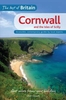
£12.99
Topographic survey of France at 1:25, 000 in IGN`s excellent TOP25 / Série Bleue series. All the maps are GPS compatible, with a 1km UTM grid plus latitude & longitude lines at 5’ intervals. Contours are at 5m intervals except for mountainous areas where the maps have contours at 10m intervals, vividly enhanced by hill shading & graphics for rocky terrain. Colouring with graphics indicates different types of vegetation or land use (deciduous or coniferous forests, moors, orchards, vineyards, etc). PLEASE NOTE: coverage of France at this scale is currently being revised – the format & the presentation of each title are indicated by the letters at the end of its Sheet Reference number (e.g. 0416ET, 3531ETR, 1923SB, etc.)MAPS WITH FULL TOURIST OVERPRINT & AN ENGLISH MAP LEGEND: all TOP25 maps & the SB editions of Série Bleue have an overprint highlighting waymarked walking trails including long-distance GR routes &, where appropriate, ski routes. Symbols indicate campsites, gîtes d’etape, refuges, equestrian centres & other recreational facilities or sites, tourist information centres, cultural heritage, etc. Towns & locations of particular interest are highlighted.- ET or OT = single-sided TOP25 map covering approx. 29x 21 km / 18x 13 miles.- ETR or OTR = waterproof & tear resistant TOP25 map covering the same area as the corresponding ET or OT number, but double-sided, printed on a smaller size sheet with a good overlap between the sides.- SB = Série Bleue map with full tourist overprint; these maps, first introduced in summer 2014, each cover approx. 29x 24km / 18x 15 miles.SÉRIE BLEUE maps with numbers ending in E (Est) or O (Ouest): most editions now indicate the GR routes, but do not show any other tourist information. Map legend is in French only. Each map covers approx. 14x 20km / 9x 12 miles. ...
Archived Product
£5.95
This book describes 30 traditional Cornish festivals & recent revivals, linking them imaginatively with traditional dishes & modern feasts using local ingredients. Each festival is illustrated with a quirky, fun illustration & accompanying recipe, old or new. For each recipe there is a photo of the finished dish. The book provides a lively, sometimes idiosyncratic, look at Cornish history, folklore, food & customs. It guides you around the county & enables you to cook your own Cornish feast. ...
Archived Product
£5.95
In 2006, UNESCO designated Cornwall & West Devon Mining Landscape a World Heritage Site. In the eighteenth century, Cornwall was one of the country`s principal industrial areas. Before the late 1870s, it produced more tin than any other region in the world, & in the early nineteenth century its output of copper was two-thirds of world production. The remains of the mines contribute to a distinctive cultural landscape; more than 200 engine houses survive
- the largest concentration of such monuments in the world. This book, & its companion Cornish Mines: St Just to Redruth, is a guide to the best examples of the surviving mines, with stunning photographs & authoritative text.
...
Archived Product
£10.99
Corno alle Scale area in the Alto Appennino Bolognese on a contoured & GPS compatible map at 1:25, 000 from L` Escursionista Editore highlighting waymarked walking trails & other local paths, not signposted but open to hikers. Topography is presented by contours at 20m intervals with relief shading & colouring indicating orchards & woodlands, plus boundaries of protected areas. Waymarked trails are shown with their route numbers, & the map also highlights other hiking routes open to the general public, indicating points where access may be closed as the path crosses private property. The map has a 1km UTM grid. Map legend

Includes::
English. The map comes with a booklet, in Italian only, describing the area & its sights. To see the other titles in this series please click on the series link.

...
Archived Product
£7.99
Food, once the shame of the British nation, is now the object of our shameless, salivatory interest. Cookery is never off our TV screens, nor out of our newspapers. A revolution is afoot, in short, & never in the field of human nutrition have so many people eaten so well. So, at least, we are led to believe. But in the course of a dyspeptic journey around the eating places, the fine food producers, the markets & supermarkets of Britain, expatriate gastronome Paul Richardson found that the truth is more complex, more intriguing & much more amusing. He chats to chefs & shoppers, foodie faddists & junk food junkies. He visits cheesemakers, bakers, smokehouses, coffee houses, & artisan producers of everything from ham & jam to cakes & ale. Democratic to the last, he tastes his way through deep-fried Mars bars in Newcastle, udder in Accrington, pasties in Padstow, & foie gras three ways on a buckwheat pancake in Fulham, interpolating his narrative with fascinating 'bites' of culinary lore. With wit, warmth & a refreshing lemon-squeeze of scepticism, Paul Richardson shows that British food is all these things & more. ...
Archived Product
£35.00
Cornwall is a land apart, one which has had a strong sense of its separate identity throughout history. Here are some of the richest & best preserved prehistoric & medieval landscapes in Britain, medieval castles & later coastal defences, & a land of inscribed stones, holy wells, wayside crosses & small churchtowns, scattered throughout its diverse countryside & along its beautiful coastline. Its medieval churches show monumental Norman fonts, accomplished C14 sculpture, striking C15 west towers & generously proportioned C15 & C16 aisles, with a wealth of medieval & Renaissance bench ends. Major houses can be found from all periods ranging from the spectacular mansions of the mining magnates like Tregothnan & Lanhydrock, through the supremely picturesque as at St Michael`s Mount, to the exquisite Elizabethan of Trerice. The smaller houses of the Cornish gentry survive in significant numbers from the medieval period, many refashioned in the C18 & C19. Threaded through almost every landscape is evidence of Cornwall`s distinguished mining history, & its towns, remarkably well preserved, offer fine public buildings of the C18 & C19, & at Truro the greatest English cathedral of the Victorian age. Among the architectural highlights of the last century are Lutyen`s dramatic extension to Penheale, Modernist seaside houses, Barbara Hepworth`s sculpture garden & the vast biomes of the Eden Project. ...
Archived Product
£7.99
Short Walks Cornwall covering parts of Trelissick, St Agnes & the Lizard. This selection offers interest & regional variety in Cornwall, providing the best short walks in the area. Covering walks through the whole of Snowdonia, both popular & little know scenic routes including the Launceston & the Minack theatre.- See walk locations by Looking Inside Inside:-20 circular walks up to 5 miles- Clear, large scale Ordnance Survey route maps- GPS reference for all Cornwall waypoints- Where to park, good pubs & places of interest en route- All routes have been fully researched & written by expert outdoor writers
- Beautiful photography of scenes from the walks Ideal for families, or for those who prefer shorter distances, Short Walks guides contain 20 walks graded by distance, duration & difficulty. Each route

Includes::
points of interest as well as fun observation questions for children.


...
Archived Product
£5.95
Cornwall in a series of colourful reproductions of attractive county maps by John Speede from about 1610-1611, printed on thick art paper & ideal for framing. Each title, 58 x 45cm / approx. 23” x 18”, is decorated with additional notes, drawings, coats of arms, street plans, etc. Little drawings are used to show locations of towns, larger villages, hills & woodlands or parks. Rivers & lakes are also drawn, as are boundaries of the administrative subdivisions with the names of the Hundreds. Surrounding the county are decorative panels filled with additional information which differs from title to title: street plans, coats of arms of notable local families, geographical features, notes about local history, etc. ...
Archived Product
£9.99
Cornwall in the AA Leisure Guide series; exploring the walking, cycling & car touring opportunities in a range of British destinations. The guides also provide details of outdoor activities, local events & festivals, shopping, the best pubs & tea-rooms & the must-see attractions in each region. Each title in the series allows readers to find individual sections easily & is designed for practical use on the road. An illustrated Essential Sights introductory section lists some of the region ...
Archived Product
£12.99
Every year, more & more people are choosing to snub the long-haul flights & rigorous security checks & holiday in Britain. Cornwall offers the best of Britain`s stylish, contemporary facilities mixed with stunning landscapes & fascinating heritage, & this guidebook is researched & written by a local writer who know the area like the back of her h&. The Best of Britain series uniquely brings together local knowledge of the area & expert advice, to make sure you get the most out of your visit. The guide
Includes::
- The best attractions for young couples, families & groups of friends
- Recommendations from local characters & celebrities
- Where to find fresh organic & local produce & tucked-away farm shops & delis
- Recommended places to eat out
- from quirky cafes to Michelin-starred restaurants
- Wet-weather options
- for when the unpredictable British weather lets you down
- Great things to do with children (and where to go to get away from them!)
- The best places to stay
- from cosy cottages to boutique hotels
- Local legends, festivals & pubs


...
Archived Product

Cornwall

Cornwall at 1:100, 000 on the Ordnance Survey Tour Map No. 1, with the Isles of Scilly shown as an inset. More insets present town navigation maps of St Ives, Falmouth, Newquay, Hugh Town, Padstow, Bude, Launceston, Penzance, Helston, Bodmin, Truro, St Austell, Fowey, and Looe, plus an overview of the whole area with cycle routes and national hiking trails. Additional topographic information includes sandy beaches, dunes, foreshore and high water mark. Also included are lists of selected places of interest, market days and farmer markets. Edition F; Publication Date: February 2011 About this series:Ordnance Survey
RIP - This product is no longer available on our network. It was last seen on 25.09.2019

This page now acts as a permanent archive for this product. Add more information using the comments box below to ensure it can still be found by future generations.

Use our search facility to see if it is available from an alternative contributor.
  • Availability: Out Of Stock
  • Supplier: Stanfords
  • SKU: 9780319245378
Availability: In Stock
£3.99

Product Description

Cornwall at 1:100, 000 on the Ordnance Survey Tour Map No. 1, with the Isles of Scilly shown as an inset. More insets present town navigation maps of St Ives, Falmouth, Newquay, Hugh Town, Padstow, Bude, Launceston, Penzance, Helston, Bodmin, Truro, St Austell, Fowey, & Looe, plus an overview of the whole area with cycle routes & national hiking trails. Additional topographic information

Includes::
sandy beaches, dunes, foreshore & high water mark. Also included are lists of selected places of interest, market days & farmer markets. Edition F; Publication Date: February 2011 About this series: Ordnance Survey

Reviews/Comments

Add New

Price History

Vouchers

No voucher codes found.
Do you know a voucher code for this product or supplier? Add it to Insights for others to use.

Facebook

Jargon Buster

Hiking - An outdoor activity envolving walking in nature
Date - A day on a calendar
Date - A social activity whith a current or potential partner
water - A chemical substance. Chemical formula H2O.
Truro - A city and parish in Cornwall, England

Supplier Information

Stanfords
Stanfords was established in 1853 and opened their iconic Covent Garden flagship store in 1901. They have become the top retailer of maps, travel books and accessories in the UK and arguably offer the largest selection of maps and travel books worldwide. Famous names such as Captain Robert Falcon Scott, Ranulph Fiennes and Michael Palin have purchased from Stanfords. They now have a shop in Bristol and both stores together with other venues operate a calendar of events including talks, book signings and exhibitions. As a specialist map retailer, the map selection is comprehensive and includes road maps, street maps and walking maps from worldwide destinations, as well as a selection of world atlases and wall maps. Books include travel guides and travel literature. Stanfords also stock globes, from miniatures made of blue marble to magnificent floor-standing globes. The website features a selection of interesting articles on travel topics.
Page Updated: 2023-11-12 20:15:36

Community Generated Product Tags

Oh No! The productWIKI community hasn't generated any tags for this product yet!
Menu