
 United Kingdom
 France
 Germany
 Netherlands
 Sweden
 USA
USA
 Italy
Italy
 Spain
Spain
More From Contributor


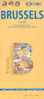
Brussels
Brussels in a series of street plans from Rough Guides published on very light waterproof and tear-resistant plastic paper, indexed, with recommendations for shops, restaurants, cafes and cars, and venues. The plan is folded to only 9x19cm when detached from its protective cover, and can be easily rolled or folded into smaller size without any damage or creases.On one side is a plan of central districts of the city at 1:9, 700, including the Eurostar and Thalys terminal at Gare du Midi, the European Quarter with the EU institutions, and Parc du Cinquantenaire. The plan is extended further south on the reverse side to include the Ixelles West district.The city centre is shown in greater detail enlarged to 1:5, 700. Also provided is a plan of the Laeken and Haysel area with the
Atomium. All the plans show tram routes with line numbers and stops, metro stations, taxi ranks, car parks and one way streets. Streets are also annotated with numbers of bus routes. Famous buildings, cultural institutions, etc. are highlighted and named. The plans are also annotated with colour-coded markers indicating publishers
Atomium. All the plans show tram routes with line numbers and stops, metro stations, taxi ranks, car parks and one way streets. Streets are also annotated with numbers of bus routes. Famous buildings, cultural institutions, etc. are highlighted and named. The plans are also annotated with colour-coded markers indicating publishers
Product Description
Reviews/Comments
Add New
Intelligent Comparison
Archived Product

Brussels Stanfords
£4.99
Archived Product
Brussels Stanfords
£10.39
Archived Product
Brussels 1844 Stanfords
£120.00
Archived Product
Brussels Borch Stanfords
£8.99
Archived Product
Brunel Stanfords
£8.99
Vouchers
No voucher codes found.
Do you know a voucher code for this product or supplier? Add it to Insights for others to use.
Do you know a voucher code for this product or supplier? Add it to Insights for others to use.
 Denmark