
 United Kingdom
 France
 Germany
 Netherlands
 Sweden
 USA
USA
 Italy
Italy
 Spain
Spain
More From Contributor


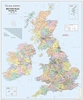


British Isles Maps International Planning Map PAPER
Wall map of the British Isles and Ireland from Maps International; at 1:600, 000 and measuring 110x160cm, this is one of our largest single sheet maps of Great Britain, almost twice the size of most other wall maps we stock.Cartography shows motorways and A roads with interchanges and service areas indicated, as well as railway lines and international airports. Counties are prominently highlighted in different colours, with their boundaries clearly marked. Ireland and Northern Ireland are shown at 1:1, 500, 000, and an enlargement shows Greater London and its boroughs at 1:450, 000. Both the British Isles and Ireland are indexed and grid-referenced.A distance table is also included, with all data given in kilometres.

Product Description
Reviews/Comments
Add New
Intelligent Comparison
Archived Product
British Isles: Map Marketing Route Planning Wall Map PAPER Stanfords
£20.99
Archived Product

Antarctica Maps International Wall Map PAPER Stanfords
£19.99
Vouchers
No voucher codes found.
Do you know a voucher code for this product or supplier? Add it to Insights for others to use.
Do you know a voucher code for this product or supplier? Add it to Insights for others to use.
 Denmark