More From Contributor

£3.50
Gheluvelt (28 NE 3
- ed. 5A) in a series of British Army trench maps from the WWI, reproduced by G.H. Smith & Son at Approx. 7/10th
...
Archived Product
£3.50
Givenchy Secion in a series of British Army trench maps from the WWI, reproduced by G.H. Smith & Son at Approx. 7/10th of the original scales"ed against each title. This very detailed h&-drawn map at 1:5, 000 shows the sector held by the King`s Own Royal Lancaster Regiment on 9th June 1918. Included is a photo & notes about 2nd Lieutenant Joseph Henry Collin of the 1st/4th Battalion who won a Victoria Cross there. Maps in this series show both the British & the enemy trenches. Several titles also indicate supply & ammunition dumps, machine gun & trench mortar emplacements, observation posts, etc. Most titles are annotated with a specific date when they were prepared & include on the reverse a glossary of terms used on the map. Some also include additional information on the regiments and/or individual solders connected with that particular part of the front. To see other titles in this series please click on the series link. ...
Archived Product
£10.99
Gulf of Naples & its islands on a detailed road map at 1:50, 000 from Freytag & Berndt, with Capri & Ischia at 1:20, 000, street plans of central Naples, Sorrento & Amalfi & a plan of the archaeological site at Pompeii. The main map covers the whole of the Gulf area, extending east to Nocera & south beyond Amalfi to include the whole of the Sorrento Peninsula & most of Monti Lattari. Ischia with Procida is shown as an inset. The map shows the area’s road network, highlighting scenic routes, &

Includes::
several hiking paths on the northern slopes of Vesuvius & in the mountain of the Sorrento Peninsula. Local ferry connections are also marked. Icons highlight various places of interest, including the archaeological sites at Pompeii & Herculaneum, campsites, beaches, marinas, castles & monasteries, etc. Along the slopes of Vesuvius lava flows show dates of various eruptions. Margin ticks give latitude at 12` intervals with longitude at 5`. Map legend

Includes::
English. On the reverse, Capri & Ischia are shown enlarged to 1:20, 000 for clearer presentation but without additional detail. Street plans cover central Naples, Sorrento, Amalfi & the towns of Capri & Ponte on Ischia. Also included is a detailed map of Pompeii highlighting various Roman remains.


...
Archived Product
£17.95
Greece
- The Aegean Islands in the Blue Guides series focuses primarily on cultural tourism for the visitor who wishes to understand
...
Archived Product
£17.95
Greece Mainland in the Blue Guides series focuses primarily on cultural tourism for the visitor who wishes to understand more of what they might see &, as such, the title provides thorough & objective reference information covering art, history & architecture. The guide features illustrations aimed to inform rather than just decorate, such as maps, diagrams, floor plans, architectural details & photographs. Cross referenced indexing means information is accessible & layout navigable. Selective listings of restaurants & accommodation are chosen in the belief that good, practical recommendations will contribute to the enjoyment of good art & culture. ...
Archived Product
£34.99
Wall map of the British Isles & Ireland from Maps International; at 1:600, 000 & measuring 110x 160cm, this is one of our largest single sheet maps of Great Britain, almost twice the size of most other wall maps we stock. Cartography shows motorways & A roads with interchanges & service areas indicated, as well as railway lines & international airports. Counties are prominently highlighted in different colours, with their boundaries clearly marked. Ireland & Northern Ireland are shown at 1:1, 500, 000, & an enlargement shows Greater London & its boroughs at 1:450, 000. Both the British Isles & Ireland are indexed & grid-referenced.A distance table is also included, with all data given in kilometres. ...
Archived Product
£8.25
Map No. 53, Galway South-East
- Offaly West
- Tipperary North in the Discovery series from the OSI, the Ordnance Survey of

...
Archived Product
£8.25
Map No. 52, Galway South in the Discovery series from the OSI, the Ordnance Survey of Irel&, which presents the country on detailed topographic maps at 1:50, 000, with additional overprint highlighting campsites & caravan parks, youth hostels, etc. Current 4th edition of this map was published in February 2013. Maps in the Discovery series have contours at 10m intervals, with plenty of spot heights & additional altitude colouring. Graphics indicate different types of woodlands. An overprint highlights waymarked or unmarked walking trails as well as cycle routes. National or forest parks & nature reserves are marked & a range of symbols provide tourist information: campsites, caravan parks, youth hostels (An Óige & independent), tourist offices, parking & picnic places, & viewpoints. Golf courses indicate the number of holes. The maps also highlight antiquities & historical sites such as megalithic tombs, standing stones, battlefields, etc. Road network grades third class roads according to their widths &

Includes::
local tracks. Railways are shown with stations & the maps include other details expected of topographic mapping at this scale. Where appropriate, place names are given in both Irish & English. Each map covers an area of 40 x 30km (25 x 19 miles approximately) & has a 1km ITM (Irish Transverse Mercator) grid, plus latitude & longitude margin ticks at 1` intervals. Map legend is in Irish & English. To see the list of all the titles in this series please click on the series link.

...
Archived Product
£14.99
A unique, bilingual English/ French guide to 300 buildings, fortifications, etc, in 30 different locations across France classified by UNESCO as World Heritage Sites, all illustrated by lovely watercolour drawings & presented with location maps, plus a fold-out map of the whole country. The guide covers not only the country’s famous art & architectural treasures: prehistoric caves, Pont du Gard & Orange, Vézelay & Fontenay, Gothic cathedrals, palaces & chateaux, Vauban’s fortifications, etc, but also the belfry towers of Pas-de-Calais or Canal du Midi. Each site, or a group of buildings such the chateaux of the Loire Valley, has a bilingual description in English & French, is illustrated with watercolour drawings, & is accompanied by a road map or a street plan. The guide also

Includes::
a glossary of architectural terms & a distance table. A fold out map of the whole country helps to provide an overview of all sites. The guide will be of particular interest to anyone interested in the pilgrimage route of Chemin de Saint-Jacques
- the Way of St James, with a special section covering the many religious buildings of south-western France.


...
Archived Product
£5.50
ADAC, Germany's equivalent of the British Automobile Association publishes an extensive series of street plans which provide detailed high-quality mapping of all the major towns & cities, including their outer suburbs. The plans name all the individual streets & indicate all the main landmarks & public buildings. All public transport facilities are shown: buses, trams, underground & overland rail lines. One way streets & car parks are indicated. Plans of larger cities include an enlargement for the city centre. The plans also show the administrative & postal divisions & have an extensive street index which, where appropriate, shows individual postal codes for each street. On the reverse, each plan has a road map at 1:100, 000, covering a very wide area around the city. Map legend

Includes::
English.

...
Archived Product

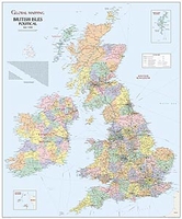
British Isles Global Mapping Political Wall Map SMALL PAPER

Political wall map of the British Isles at 1:1, 300, 000 from Global Mapping, showing different counties in bold colouring. This is an ideal reference map, showing major cities, motorways and A roads. Ferry routes and airports are also indicated. There is also a distance table for numerous destinations, as well as separate insets showing the Channel and Shetland Islands.
RIP - This product is no longer available on our network. It was last seen on 25.09.2019

This page now acts as a permanent archive for this product. Add more information using the comments box below to ensure it can still be found by future generations.

Use our search facility to see if it is available from an alternative contributor.
  • Availability: Out Of Stock
  • Supplier: Stanfords
  • SKU: 9781905755080
Availability: In Stock
£8.99

Product Description

Political wall map of the British Isles at 1:1, 300, 000 from Global Mapping, showing different counties in bold colouring. This is an ideal reference map, showing major cities, motorways & A roads. Ferry routes & airports are also indicated. There is also a distance table for numerous destinations, as well as separate insets showing the Channel & Shetland Islands.

Reviews/Comments

Add New

Price History

Vouchers

No voucher codes found.
Do you know a voucher code for this product or supplier? Add it to Insights for others to use.

Facebook

Jargon Buster

Paper - A thin sheet mainly used for writing. Available in a variety of colours. Made mainly from wood pulp.
Wall - A physical barrier between two areas
Small - something that takes up less space than normal.
Reference - To prove evidence with a back up source.
Ideal - Something that satisfies a perfect criteria.

Supplier Information

Stanfords
Stanfords was established in 1853 and opened their iconic Covent Garden flagship store in 1901. They have become the top retailer of maps, travel books and accessories in the UK and arguably offer the largest selection of maps and travel books worldwide. Famous names such as Captain Robert Falcon Scott, Ranulph Fiennes and Michael Palin have purchased from Stanfords. They now have a shop in Bristol and both stores together with other venues operate a calendar of events including talks, book signings and exhibitions. As a specialist map retailer, the map selection is comprehensive and includes road maps, street maps and walking maps from worldwide destinations, as well as a selection of world atlases and wall maps. Books include travel guides and travel literature. Stanfords also stock globes, from miniatures made of blue marble to magnificent floor-standing globes. The website features a selection of interesting articles on travel topics.
Page Updated: 2023-11-12 20:15:36

Community Generated Product Tags

Oh No! The productWIKI community hasn't generated any tags for this product yet!
Menu